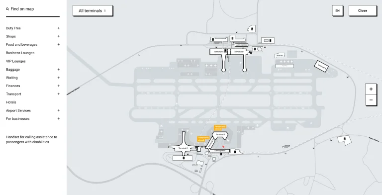
Albuquerque International Sunport Map (Most Up-To-Date)
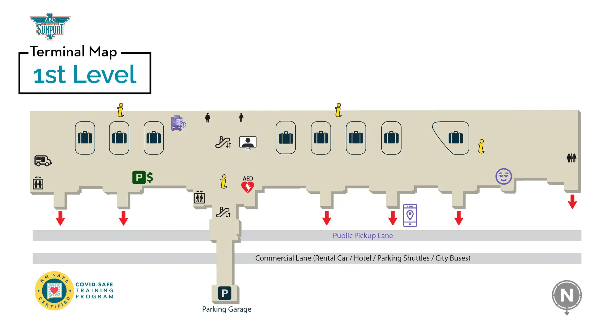
Albuquerque International Sunport uses a compact, centralized terminal with two concourses branching off a single post-security hub, stacked across three public levels. The building runs roughly east–west, with Arrivals/Baggage Claim on Level 1, Ticketing on Level 2, and one centralized TSA checkpoint on Level 3. Landside traffic and pickups concentrate along the Level 1 curb, making door numbers and parking-to-terminal paths the most important waypoints within Albuquerque’s main airport complex.
Map Table
| Terminal | Key Airlines | Primary Function | Transfer Mode |
|---|---|---|---|
| Level 1 (Arrivals) | — | Baggage claim, ground transport curbs, Door 1–7 | Walk, curb pickup, shuttles |
| Level 2 (Ticketing) | Southwest, United, American, Delta, JetBlue | Check-in counters, bag drop | Walk, garage skybridge |
| Level 3 (Security) | — | Single TSA checkpoint, T-Connector hub | Escalator, elevator |
| Concourse A (West) | Southwest, United | Gates A1–A14, longer pier | Walk, moving walkways |
| Concourse B (East) | Delta, American, JetBlue | Gates B1–B10 | Walk |
| Rental Car Center (Remote) | Major rental brands | Consolidated rental facility | Shuttle bus |
Albuquerque International Sunport Map Strategy
- Treat parking as a two-path decision: Garage first, then immediate pivot to Basic Economy with the walk-to-terminal sidewalk if “FULL” signage appears.
- Use door numbers as your ground-transport GPS: Door 7 for rideshare geofences, Door 2 for the taxi fail-safe, Doors 3–5 as the shortest “baggage → rental shuttle” exits.
- Assume shuttle variance during peaks and late-night edges: only wait if a bus is visible; otherwise walk when a paved path exists (especially from Basic Economy).
- Plan for “closed/not staffed” gaps: stage at the Great Hall core for early TSA openings, then target post-security automated retail as the reliable food/water node.
2026 Albuquerque International Sunport Map + Printable PDF
Day-to-day navigation at 2026 Albuquerque International Sunport still centers on the same chokepoints: one centralized TSA checkpoint on Level 3, an Arrivals-heavy Level 1 curb with door-based pickup rules, and parking lots that can flip from “easy” to “full” quickly. The most printable-map-relevant details are the door numbers (especially Door 7 rideshare, Door 2 taxis) and the walkable economy-lot fallback path.
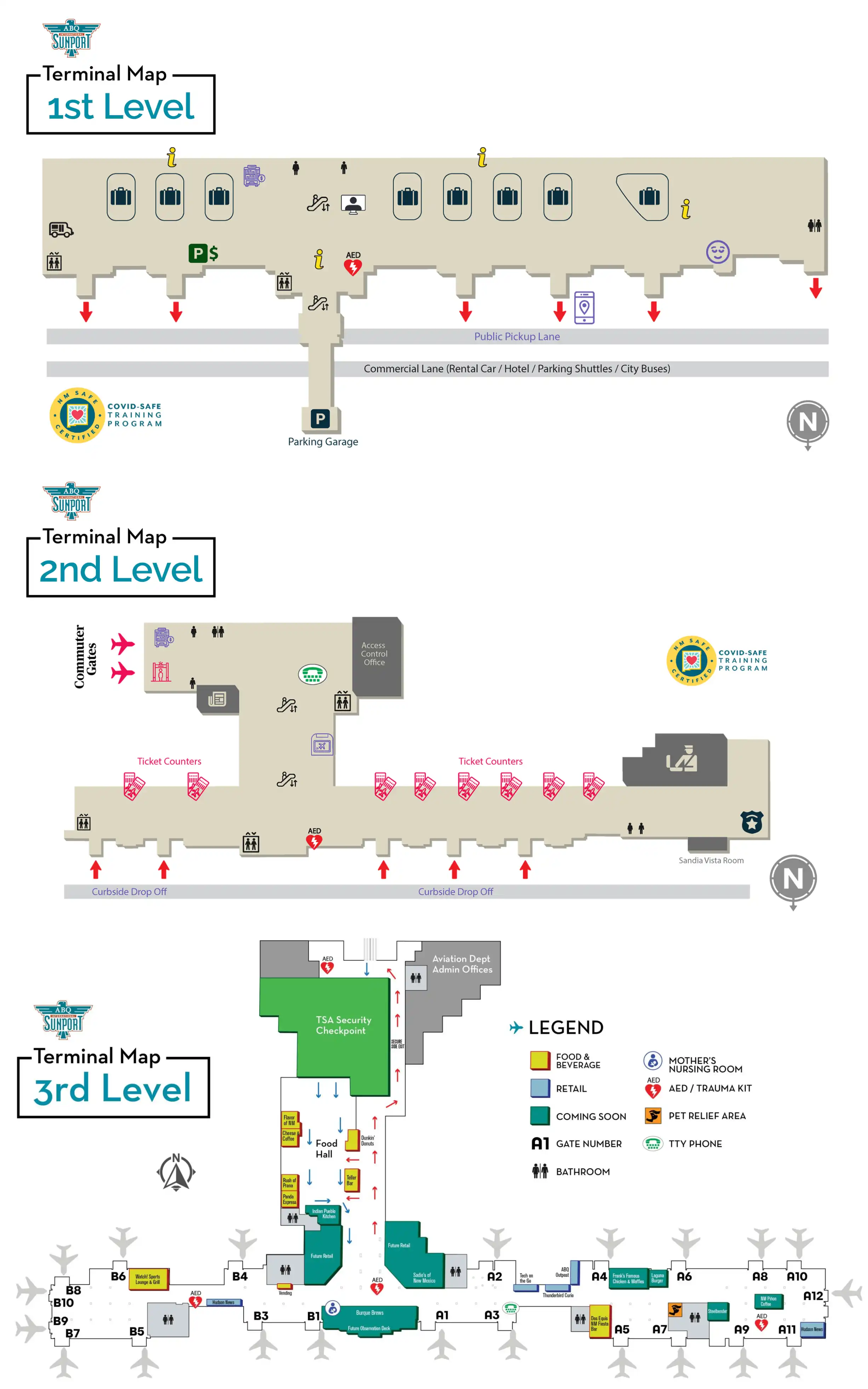
Albuquerque International Sunport Level 1 Map 2025
Albuquerque International Sunport Level 2 Map 2025
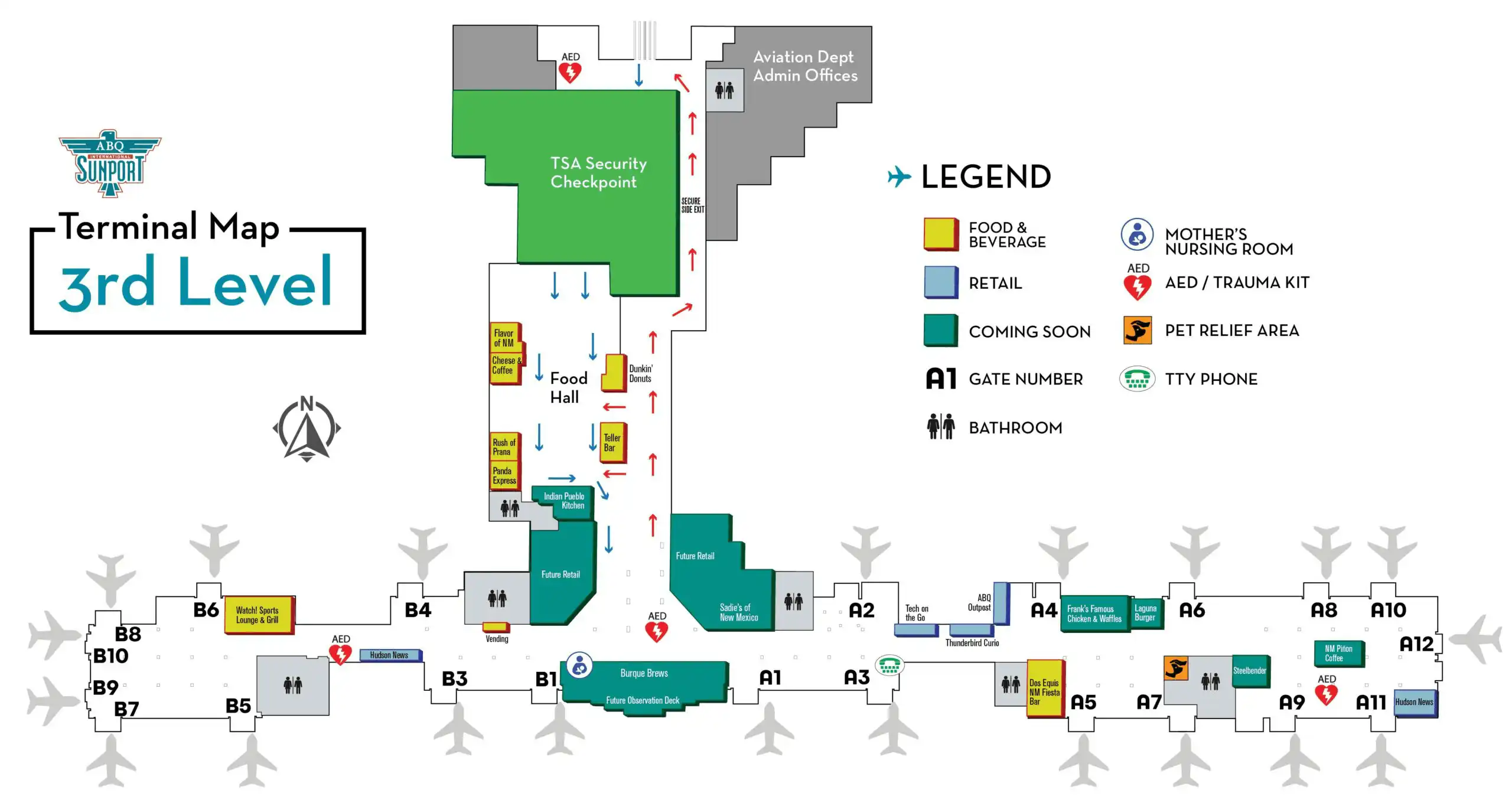
Albuquerque International Sunport Level 3 Map 2025
2026 Albuquerque International Sunport Map Guide
What is the exact walking route and distance (in feet/meters) from the economy/cheaper parking shuttle drop-off to the main terminal entrance doors at Albuquerque International Sunport?
Walking takes about 800–1,200 feet (about 245–365 meters) from the cheaper economy-lot area to the main Level 1 terminal entrance doors, depending on where you start within the lot.
The most reliable on-foot route starts in the Basic Economy lot’s northwest side (the side closest to the Parking Garage). From the shuttle shelter area, follow the paved sidewalk westbound, keeping the Arrivals Level roadway on your left as you pass the Premium Economy perimeter and the ground-level entrance area of the Parking Garage. Continue straight toward the terminal façade and enter at the Level 1 Baggage Claim doors on the east side of the arrivals frontage. This walk typically runs 4–7 minutes and avoids shuttle “bunching” delays.
Where is the precise rideshare (Uber/Lyft) pickup point located relative to Baggage Claim, including the level (arrivals/departures) and door number?
Rideshare pickup is on Level 1 (Arrivals) at Door 7, at the west end of the terminal curb.
From the center of Baggage Claim, walk west along the public hall toward the higher-numbered doors until you reach Door 7. Exit through Door 7 to the Arrivals curb and look for “TNC” or “Rideshare” signage marking the app-based pickup zone. If it’s late and Uber/Lyft supply is poor, the fastest fail-safe is to walk east to Door 2 for the taxi stand; the Door 7 to Door 2 walk is roughly 200–300 feet (about 60–90 meters) along the same Level 1 frontage.
What is the exact indoor route and walking distance from Baggage Claim to the rental car shuttle pickup zone, including which doors to exit?
The rental car shuttle pickup is reached by exiting Baggage Claim on Level 1 through the central doors (Doors 3–5) and walking straight to the median “Commercial Lane” island.
From your carousel, walk to the nearest set of central glass exit doors in Baggage Claim, aiming for Doors 3, 4, or 5 to minimize side-to-side curb walking. Exit to the Arrivals curb, then cross the inner private-vehicle lane at the marked crosswalk to the median island (the second island from the building). The rental shuttle stop is the bus-shelter area signed for “Rental Car Shuttle.” The walk is short—typically about 150–300 feet (about 45–90 meters) from the doors to the shelter—because the shuttle zone sits directly opposite the central exits.
Which parking lots are physically closest by walking distance to the terminal entrance, and what is the shortest on-foot path from each lot to check-in?
The Parking Garage is the closest on-foot option, with direct adjacency and skybridge/elevator access into the terminal core.
| Parking option | Closest terminal entry | Shortest on-foot path to check-in |
|---|---|---|
| Parking Garage | Garage-to-terminal skybridge/core | Elevator/stairs to skybridge, enter terminal, walk to Level 2 counters |
| Premium Economy Lot | Level 1/2 frontage near the garage side | Follow the marked pedestrian walkway toward the terminal façade, enter, then go up to Level 2 ticketing |
| Basic Economy Lot | Level 1 Baggage Claim doors | Take the paved sidewalk westbound along the Arrivals roadway, pass the Premium Economy edge and garage frontage, enter at Level 1, then go up to Level 2 ticketing |
Where is the cell phone waiting area located relative to the arrivals pickup curb, and what is the exact driving path to loop back to pickup?
The cell phone waiting area is at 2325 Sunport Loop SE, north of the terminal and near the Sheraton, positioned on the internal return-loop side of the airport road system.
From the cell phone lot, exit onto Sunport Loop SE and follow internal signs for “Terminal / Arrivals” to merge back toward Sunport Boulevard and the terminal approach. Stay inside the airport complex; don’t peel out toward Yale Boulevard or Gibson Boulevard, because that forces a longer city-street re-entry. The key decision fork is the point where the roadway tempts you to “exit” toward Yale—ignore that and follow “Return to Terminal” signage until you’re funneled back into the Level 1 Arrivals curb lanes.
What is the exact location of the TSA checkpoint entrance inside the terminal (landmarks + corridor), and which approach route minimizes backtracking from check-in?
The TSA checkpoint entrance is on Level 3 at the top of the central escalator/elevator core, directly off the Great Hall atrium at the throat of the T-Connector.
From airline check-in on Level 2, finish your counter stop first, then walk to the middle of the Ticketing Hall to find the main escalator bank and elevator cluster (the central vertical core). Go up one level to Level 3; the TSA queuing area and document-check podiums are straight ahead from the escalator landing, with the Great Hall open space behind you and the concourse split beyond security. This route avoids side corridors and prevents the common mistake of wandering laterally on Level 2 and then backtracking to find the only checkpoint.
What is the walking distance from TSA exit to the farthest gate cluster, measured as a single continuous path on the concourse map?
Walking runs about 1,200–1,500 feet (about 365–460 meters) from the TSA exit to the farthest gate cluster, with the longest single path typically ending at Gate A14.
After you exit the centralized checkpoint, stay in the T-Connector hub and turn left for Concourse A (the longer pier). Continue straight down the main corridor toward the highest A gate numbers until the concourse widens at the end seating area near Gate A14. This route includes the short T-Connector span (roughly 200–300 feet) plus the full Concourse A spine (roughly 1,000–1,200 feet), and moving walkways along the central spine can reduce time without changing the path.
Where are the closest guaranteed food/snack fallback points (e.g., kiosks/vending/convenience) located post-security, and what is the shortest route from TSA exit to reach them?
Roadrunner Express in Concourse A is the closest “guaranteed” post-security snack fallback because it functions as automated retail when staffed kitchens are closed.
From the TSA exit at the T-Connector, turn left toward Concourse A and walk into the concourse until you reach the Roadrunner Express automated retail area (signed with Roadrunner branding). If you need something even closer to the checkpoint, Hudson News at the T-Connector is the nearest convenience option; walk only a short distance from the TSA exit into the hub area between Concourses A and B and use the self-checkout kiosks for packaged items when counters are closed.
Where are the largest seating clusters (highest seat count area) located post-security, and what is the shortest walking route from TSA exit to those seats?
The largest seating clusters are typically at the end-of-pier holdrooms, especially the expanded seating area near Gate A14 and a similar end cluster near Gate B10.
From the TSA exit at the T-Connector, turn left for Concourse A and walk straight down the main corridor to the far end near Gate A14, where the concourse flares into a larger waiting area. For an east-side alternative, turn right for Concourse B and continue to the far end near Gate B10, which also concentrates seating and is often quieter between departure banks. Both routes are single-corridor walks from the TSA hub with no mid-concourse turns—just follow the gate-number progression to the end.
What is the exact path from the arrivals pickup curb to the departures drop-off curb (or vice versa), and where are the decision forks that cause wrong turns?
The curb-to-curb move forces you onto Sunport Boulevard first, because you can’t reliably “pop up” between levels without taking the correct ramp split on the terminal approach.
The path starts at the Level 1 Arrivals curb, where traffic is funneled outbound onto Sunport Boulevard eastbound. Continue east, then use a legal turnaround via the Girard Boulevard intersection or the Yale Boulevard interchange to reverse direction and return westbound toward the terminal. On the re-approach, the main decision fork is the vertical ramp split: follow overhead signs for “Departures / Ticketing” to climb to Level 2. Taking the “Arrivals” ramp again drops you back into the Level 1 curb loop and recreates the same congestion trap.
Where are the baggage carousels positioned relative to ground transportation exits, and which carousel-to-exit route is shortest for rental-car vs rideshare pickups?
The baggage claim carousels sit linearly on Level 1 with exits distributed along the same frontage, so the shortest route depends on which door you’re targeting rather than a specific carousel number.
For rideshare, the shortest path is to move west inside Baggage Claim and exit at Door 7, then step directly into the Level 1 rideshare/TNC pickup zone. For rental cars, the shortest path is to exit through the central doors (Doors 3–5) and walk straight across the inner curb lane to the median “Commercial Lane” island where the Rental Car Shuttle shelter is located. If you’re aiming for taxis instead of rideshare, exit at Door 2; it’s the most direct curbside node for the taxi stand and the best late-night fallback when apps show long waits or no cars.