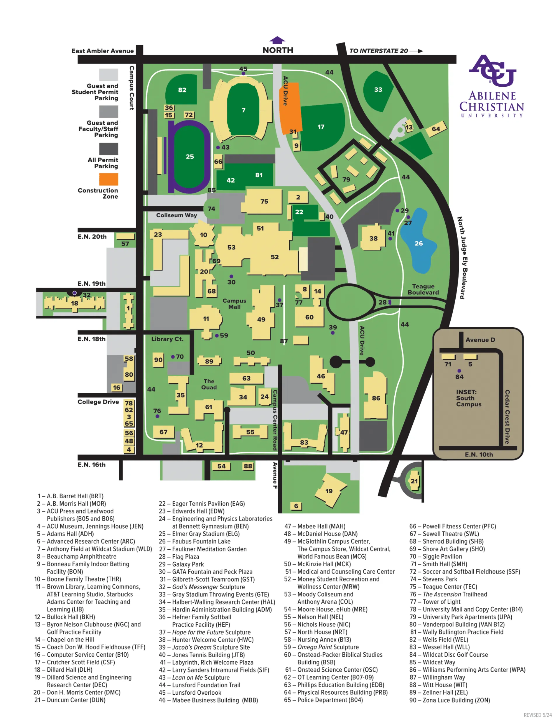
Abilene Christian University Campus Map (2025-2024)
The Abilene Christian University Campus Map provides a clear overview of academic, residential, and athletic zones across the Abilene, Texas campus. It highlights the Main Quad, Faubus Fountain Lake, and Wildcat Way as central orientation points, with key academic buildings like the Hardin Administration Building, Brown Library, and Don H. Morris Center positioned near the campus core.
Major landmarks, residence halls, and athletic facilities surround these hubs, creating a cohesive, walkable layout.
Abilene Christian University Campus Map 2025

Printable Abilene Christian University Campus Map 2025
Downloadable and printer-friendly version of the campus map for offline use, including detailed labels for buildings, roads, and parking areas. Download the printable 2025 Abilene Christian University Campus Map for offline reference.
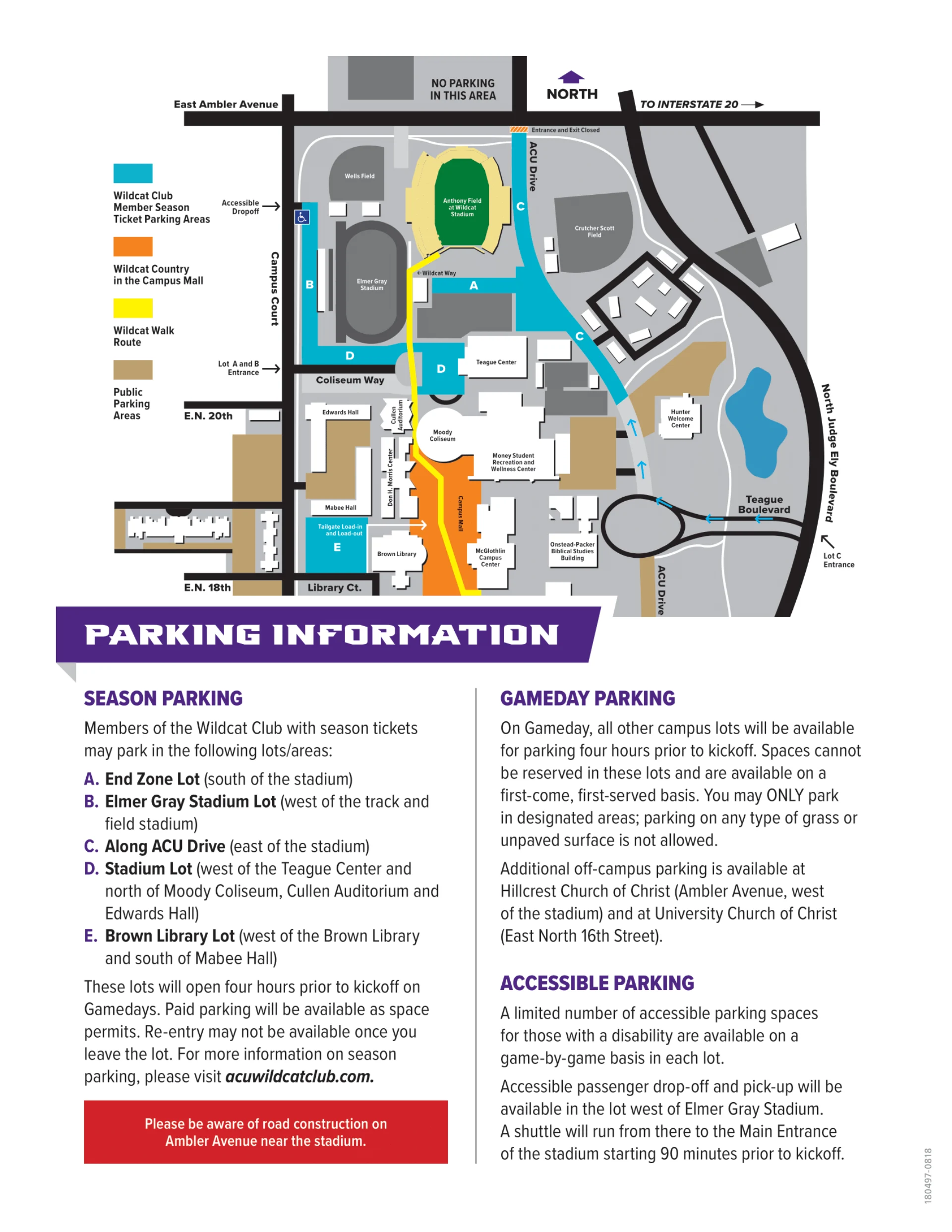
Abilene Christian University Parking Map 2025
This parking map outlines visitor lots, permit zones, and primary entry points from Judge Ely Boulevard and Ambler Avenue for convenient campus access.
Abilene Christian University Campus Guide
This guide complements the map, describing the spatial organization of Abilene Christian University and offering navigation context between academic, residential, and recreational zones.
Campus Layout & Landmarks
Abilene Christian University’s campus centers around The Quad, bordered by the Brown Library, Hardin Administration Building, and Zona Luce School of Nursing. To the south lies Faubus Fountain Lake and the Hunter Welcome Center, while Tower of Light and the McGlothlin Campus Center anchor the central mall area. Academic halls and chapels extend east and west, connecting to arts and athletics zones.
Walking Routes & Accessibility
Pedestrian paths connect the Main Quad, Campus Mall, and Faubus Fountain Lake, ensuring step-free access across the academic core. Willingham Way and Wildcat Way serve as primary walking corridors, linking residential areas to classrooms, dining, and recreation facilities. Clearly marked crosswalks and ramps promote full accessibility for visitors and students.
Parking & Entrances
Visitor parking is available near the Hunter Welcome Center and Faubus Fountain Lake along Judge Ely Boulevard. Additional lots flank Wildcat Way and the east campus border near University Park Apartments. Main entry routes include Judge Ely Boulevard from the west and Campus Court Drive from the south, providing smooth access to academic and residential areas.
Transit & Getting Here
The university is accessible via Judge Ely Boulevard and Ambler Avenue, just east of downtown Abilene. Local transit and shuttle stops are located near the Welcome Center and Campus Center. Visitors arriving from Interstate 20 can follow exits to Judge Ely Boulevard for direct campus entry, with directional signage guiding toward parking and athletic facilities.
Dorms & Student Housing
Student housing is concentrated in the eastern and southern zones, including Barret Hall, Morris Hall, Dillard Hall, Edwards Hall, and Smith Hall. McKinzie, Nelson, and Wessel Halls sit near the academic buildings, while University Park Apartments provide upper-class housing west of the athletic complex. These halls are all connected via walkways to the main quad and dining facilities.
Dining & Student Life
Dining and student services are centered in the McGlothlin Campus Center, home to The World Famous Bean, the Campus Store, and Wildcat Central. Outdoor gathering spots like the Campus Mall, GATA Fountain, and Faulkner Meditation Garden offer scenic spaces for recreation and events. Nearby Moody Coliseum and Boone Family Theatre support campus life and large community gatherings.
Older Abilene Christian University Campus Maps
Access previous years’ campus maps below for archival reference and historical layout comparisons.
Abilene Christian University Campus Map 2024
FAQ
Frequently asked questions address wayfinding, visitor parking near the Hunter Welcome Center, and navigation to major landmarks such as Wildcat Stadium and Faubus Fountain Lake.
What city is Abilene Christian University in?
Abilene Christian University is located in the city of Abilene, Texas. The university is situated in west-central Texas and serves as a major educational institution in the region.
Is Abilene Christian a dry campus?
Yes, Abilene Christian University is a dry campus. The university prohibits the possession, use, or distribution of alcohol on campus property or at university-sponsored events, regardless of age. This policy aligns with its Christian values and commitment to maintaining a substance-free environment.
What is Abilene Christian University known for?
Abilene Christian University is known for its strong Christian foundation, nationally recognized programs in business, education, and the sciences, and its commitment to undergraduate research and service. ACU is also noted for its integration of faith and learning, as well as its global mission work and leadership development.
Is ACU a private college?
ACU (Abilene Christian University) is a private university located in Abilene, Texas. It is affiliated with the Churches of Christ and offers both undergraduate and graduate degree programs. As a private institution, ACU operates independently of state government funding.


