Marseille Provence Airport Terminal 2 Map (Most Up-To-Date)
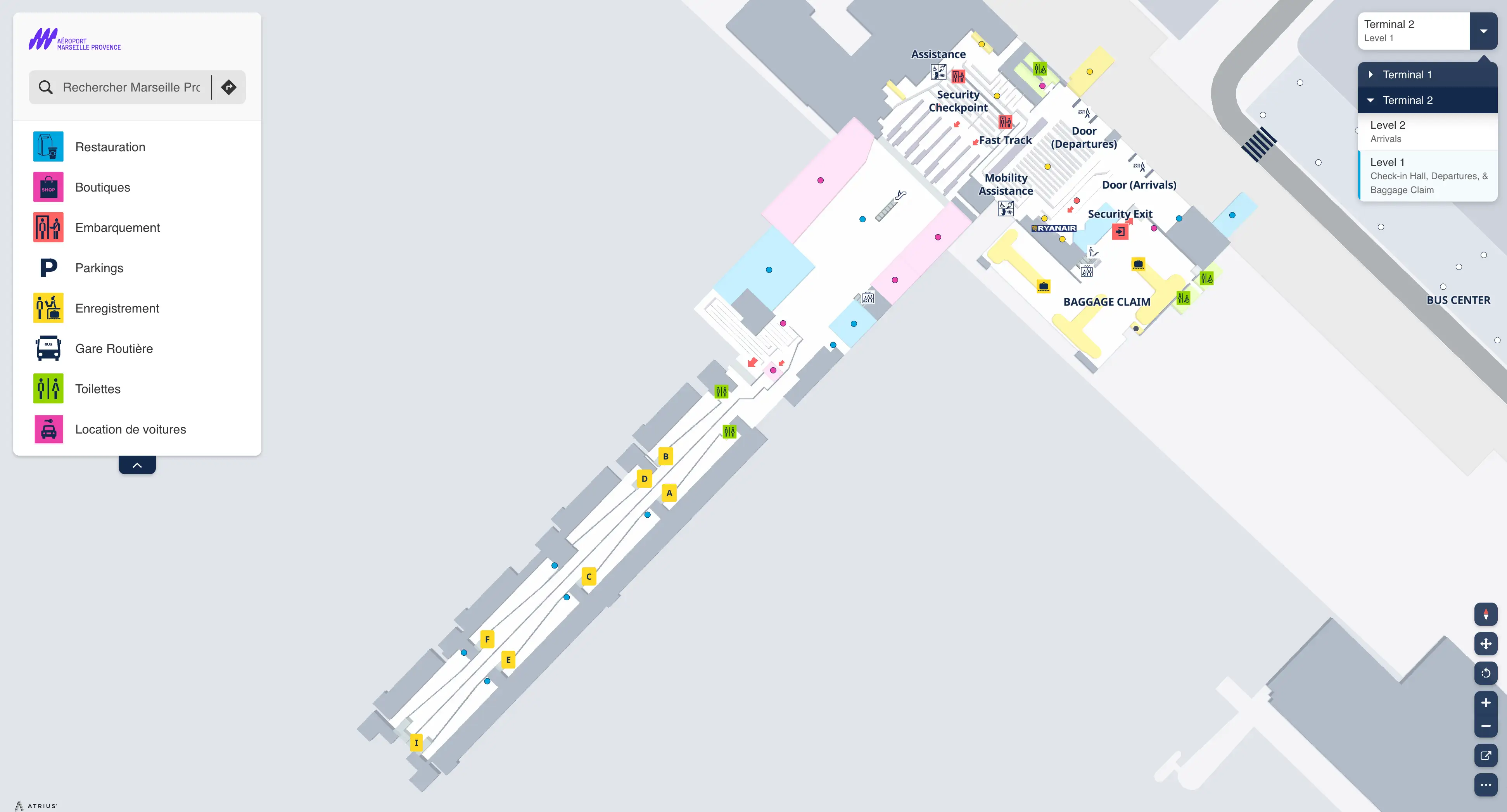
Marseille Provence Airport Terminal 2 (also known as MP2) is a compact low-cost terminal with a compressed, linear flow: landside check-in and security on the main level, then duty-free, then a second control point before a short gate corridor. Within the main Marseille airport hub, Terminal 2 sits slightly apart from Terminal 1, so key amenities and the official taxi rank skew toward the Terminal 1 forecourt, while buses cluster at the central bus station between buildings.
Map Table
| Level/Area | Primary Use | Key Friction Point | Best Connection Cue |
|---|---|---|---|
| Landside (Level 1) | check-in, bag drop, security | crowd surges, tight hall depth | main curb doors, security lanes |
| Post-security retail | duty-free funnel | false “I’m done” moment | Aelia Duty Free exit path |
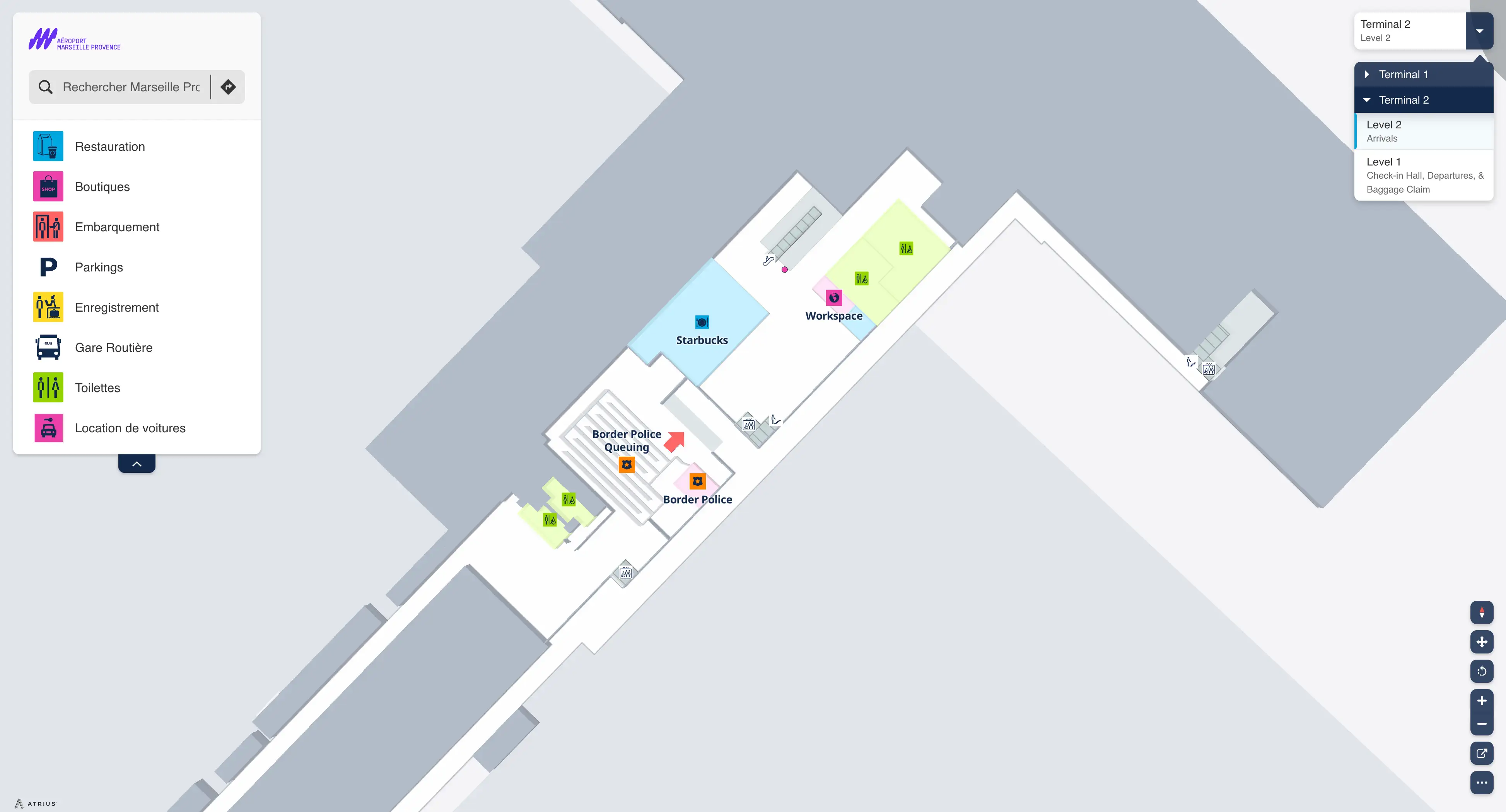
| Border/ID control | passport checkpoint zone | hidden queue chokepoint | after duty-free, before gates |
| Gates/apron access | boarding doors, ramp exits | sparse seating, bus/walk boarding | straight corridor to numbered doors |
Marseille Provence Airport Terminal 2 Map Strategy
- Assume a second chokepoint after security: walk straight through duty-free to locate the post-security border/ID checkpoint before you shop, eat, or sit.
- Treat amenities as “pre-security only”: grab coffee/food and water landside (or do the outdoor walk to Terminal 1 Hall 1A/1B) because Terminal 2 services are limited and can close early.
- Lock in ground-transport paths: from Terminal 2 exits, keep left for the central bus station (L91 and Bus 13 platforms), and plan the longer outdoor walk to the official taxi queue at the Terminal 1 forecourt.
- Eliminate naming confusion upfront: “Terminal 2” and “MP2” refer to the same low-cost annex, not Terminal 1’s Hall 1A/1B area.
2026 Marrakech Menara Airport Terminal 2 Map + Printable PDF
Terminal 2 remains the bare-bones MP2 facility, so a useful 2026 printable map is one that prioritizes flow control: where the queues form, where the second checkpoint hides, and how to reach buses and taxis without second-guessing the roadway. The biggest operational risk still isn’t the walk to gates—it’s the post-security stop that can appear suddenly and eat your buffer time.
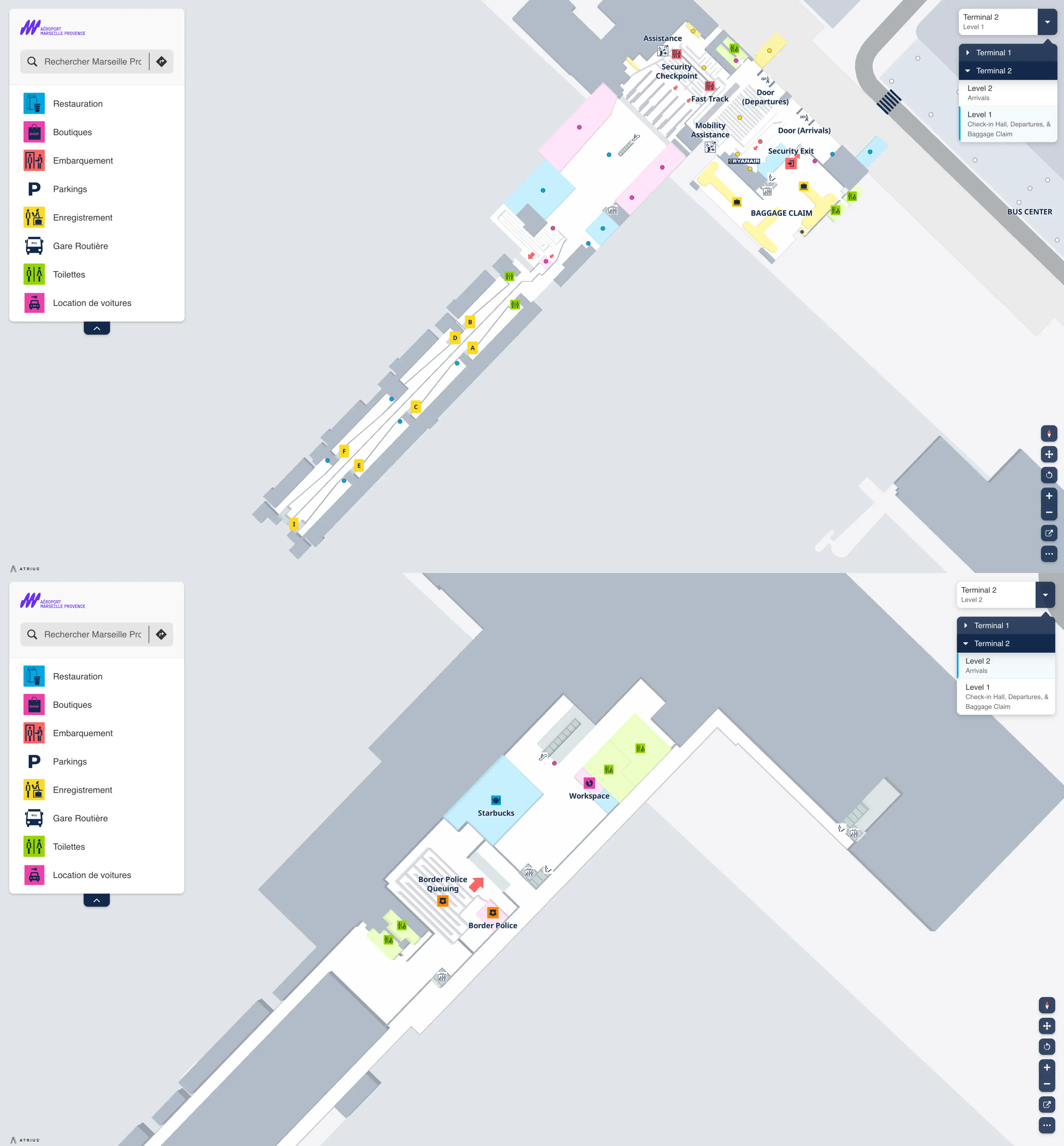
Marseille Provence Airport Terminal 2 Level 1 Map 2026
Marseille Provence Airport Terminal 2 Level 2 Map 2026
2026 Marseille Provence Airport Terminal 2 Map Guide
What is the exact walking route (and distance in meters) from Terminal 2 arrivals doors to the L91 bus stop pickup point?
Walking takes about 150–200 meters from Marseille Provence Airport Terminal 2 arrivals doors to the L91 pickup point at the central bus station.
Exit Terminal 2 to the landside curb, then keep to the left and follow the marked pedestrian sidewalk that runs along the terminal roadway toward the central bus/parking complex between Terminal 2 and Terminal 1. Stay on the pedestrian path (don’t cut across traffic lanes) until you reach the bus platforms; the L91 (Navette to Marseille Saint-Charles) boards at Platform 6, with yellow ticket vending machines positioned beside the waiting area as the easiest confirmation landmark.
Where exactly is the post-security border-control checkpoint located relative to Terminal 2 security exit (landmark-to-landmark)?
The post-security border-control checkpoint sits after the Terminal 2 security exit and after the mandatory Aelia Duty Free walkthrough, immediately before the corridor to the departure gates.
From the security exit you are funneled directly into Aelia Duty Free, then you follow the fixed retail path to its far side; the passport/border-control queue begins right after you clear the duty-free zone and turn toward the gate area. The key landmark triangulation is: security exit → Aelia Duty Free entrance → Aelia Duty Free far exit → border-control queues before the gate doors, with no long sightline from the retail area to reveal the queue until you reach that turn.
What is the precise walking distance from Terminal 2 security screening entrance to the farthest active gates in Terminal 2?
A published, exact meter distance from the Terminal 2 security screening entrance to the farthest active gates isn’t provided in the available terminal-facing materials, but the internal walk is short enough that the farthest gate is typically under a 5-minute walk once you’re clear of the post-security border-control checkpoint.
Terminal 2’s airside footprint is a compact, linear corridor rather than a long pier system, so the “walk-time risk” is dominated by standing queues, not distance. The practical landmark route is: security screening → Aelia Duty Free funnel → border/ID control zone → straight gate corridor with numbered doors; the farthest door is reached by continuing straight to the end of that corridor.
Where is the nearest staffed help/airline desk to Terminal 2 security (closest path, not “in the terminal”)?
The nearest staffed help point to Terminal 2 security is the airline check-in/bag-drop counters in the Level 1 landside check-in hall, immediately before the security entrance.
From the security queue entrance, turn back toward the check-in hall flow and walk straight to the nearest active airline counter position facing the central hall. Terminal 2 does not have a permanent staffed, multi-airline help desk post-security, so once you pass through security you are effectively in an assistance void. If a problem appears at the gates, the only reliable staffed fallback is to exit the secure area and return to the Level 1 check-in counters, which forces a full re-entry through security (and the post-security border/ID checkpoint if applicable).
What is the exact location of the Terminal 2 taxi queue relative to the main exit—left/right and how many meters?
No official licensed taxi queue sits directly outside Marseille Provence Airport Terminal 2; the regulated taxi rank is at the Terminal 1 forecourt, about 150 meters away (around a 5-minute walk).
Exit Terminal 2 to the curb and take the exterior connecting sidewalk toward the main Terminal 1 building; the taxi line begins immediately in front of Terminal 1’s main doors in the forecourt area. The usable directional cue from Terminal 2 is “walk along the exterior sidewalk toward Terminal 1,” because the exact left/right turn can vary by which Terminal 2 exit door you come out of, but the distance stays roughly the same.
What is the shortest indoor route from Terminal 2 departures to the nearest open food/coffee option in Hall 1A/1B (by walking path)?
No indoor route exists from Terminal 2 departures to Hall 1A/1B for food or coffee; the shortest usable path is a landside outdoor walk of about 150 meters that takes roughly 5–7 minutes.
From Terminal 2 departures on Level 1, stay landside (do not enter security), exit the building to the covered connecting sidewalk, and follow the pedestrian path toward Terminal 1’s Hall 1A/1B complex. The nearest practical “open” options are inside Terminal 1’s main public concourse area (the Hall 1A/1B side of the Terminal 1 complex), so your landmark confirmation is: Terminal 2 exit doors → covered exterior walkway → Terminal 1 public hall entrance → food/coffee cluster in the main concourse.
Where is the closest high-seat-capacity waiting area in Terminal 2 (the densest seating zone), and how far is it from security exit?
No true high-seat-capacity waiting area exists in Terminal 2; the densest seating is limited to small hard-seat clusters positioned along the airside gate corridor near the numbered boarding doors, and they fill immediately.
From the security exit you are routed through Aelia Duty Free and then past the border/ID checkpoint (when applicable) into the gate holding corridor. The seating “hotspots” are the benches grouped beside individual gate doors rather than a central lounge-style zone, so the best way to find the densest cluster is to target whichever gate area is currently not boarding. Distance from the security exit depends on whether the border-control queue is active; when it isn’t, you reach the first gate seating clusters within only a few minutes of walking through duty-free.
What is the exact pedestrian route from Terminal 2 arrivals to the bus 13 stop for Gare de Vitrolles (including which side of the roadway)?
Walking follows the left-side pedestrian path from Terminal 2 arrivals to the central bus station, where Bus 13 to Gare de Vitrolles boards at Platform 5.
Exit Terminal 2 arrivals to the landside curb, then keep to the left and stay on the exterior sidewalk that runs along the terminal roadway toward the central bus/parking complex between Terminal 2 and Terminal 1. Remain on the pedestrian side of the roadway (don’t cross traffic lanes) until you enter the bus station platform area; then locate Platform 5 for Bus 13. A reliable landmark check is that you’re arriving into the same central platform zone used for the L91, with ticket machines and posted platform numbers at the waiting area.
Where are the remote-stand/bus-boarding gates (or corridors) located within Terminal 2 relative to the main pier gates?
The remote-stand and bus-boarding exits are the same airside gate-door corridor system in Terminal 2, positioned along the compact linear gate area reached after duty-free and the post-security border/ID checkpoint.
Terminal 2 does not operate like a multi-pier terminal with separated concourses; instead, boarding happens through numbered doors that open toward the apron for walk-boarding or connect to bus operations for remote stands. The landmark route is: security → Aelia Duty Free → border/ID control → straight corridor of numbered gate doors; the “bus/remote stand” function is operationally assigned to specific doors in that same corridor rather than being housed in a separate satellite pier.
What is the exact location of the closest restroom to the Terminal 2 security queue entrance (meters + turns)?
The closest restroom sits landside on Level 1 next to the nursery and a vending-machine cluster, under 20 meters from the start of the Terminal 2 security queue with no meaningful turns.
From the security queue entrance, step out of the main check-in-to-security flow toward the adjacent services nook; the restroom block is immediately there beside the baby-care/nursery point and vending machines. The landmark triangulation is: security queue start → nursery area → vending machines → restroom doors, all within the same compressed check-in hall footprint.
Where is the closest “quiet corner” (low-traffic zone) in Terminal 2 for late-night waiting, and what’s the shortest path from arrivals?
No “quiet corner” exists inside Terminal 2 late at night because the terminal closes and passengers are required to leave.
From Terminal 2 arrivals, the shortest viable late-night waiting route is to relocate to Terminal 1 landside: exit Terminal 2 to the curb, follow the exterior covered sidewalk about 150 meters toward Terminal 1, enter Terminal 1, then go up to Floor 2 in Hall A where the rudimentary overnight waiting/sleep area is typically used. The practical landmark chain is: Terminal 2 exit doors → covered inter-terminal walkway → Terminal 1 Hall A entrance → escalators/elevators → Floor 2 benches/carpeting zone.
What is the exact walking distance from Terminal 2 drop-off curb to the terminal’s main check-in doors?
Walking takes under 10 meters from the Terminal 2 drop-off curb to the main check-in doors.
From the curb, you cross the single exterior sidewalk threshold directly into the Level 1 departures/check-in hall. There aren’t any intermediate forecourts or long curbside corridors like you’d see at larger terminals, so the route is essentially curb edge → sidewalk strip → sliding entrance doors into the check-in space.