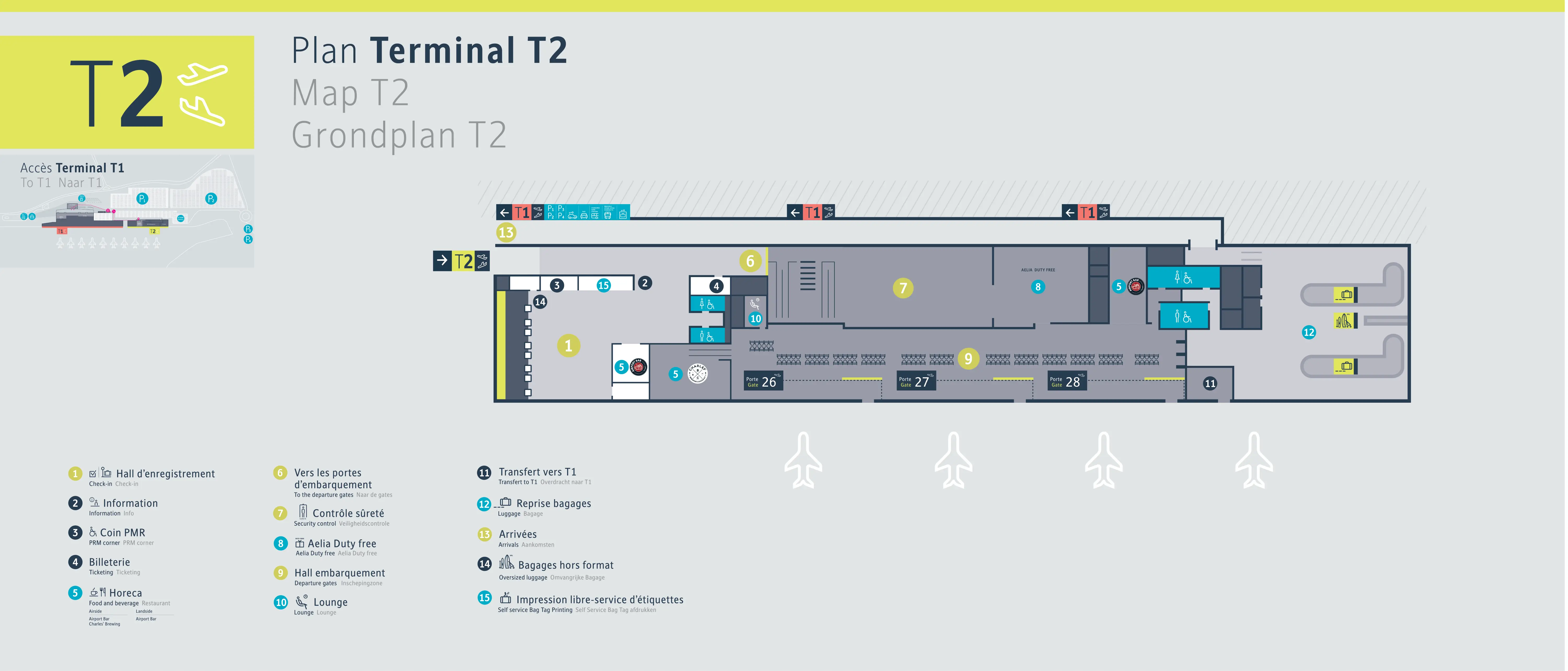
Brussels South Charleroi Airport Terminal 2 Map (Most Up-To-Date)
Brussels South Charleroi Airport Terminal 2 is a compact, rectangular “box” terminal with a straight-through flow: curb/doors → check-in hall → security → a single airside holding area with gates on the edge. As part of the wider Charleroi airport hub (with Terminal 1 about 100 meters away), it feels small in meters but large in delay risk, because queues and connector-dependent routing can consume time faster than the building’s footprint suggests.
Map Table
| Zone | Layout Shape | Primary Function | Key Dependency |
|---|---|---|---|
| Landside (T2) | Compact rectangle | LCC processing | Limited buffer space |
| Security (T2) | Immediate behind check-in | Throughput choke-point | Queue volatility |
| Airside (T2) | Single holding pen | Waiting + Gates 26–28 | Seating + power scarcity |
| Connector to T1 | Subterranean tunnel | Gate re-routing | Stairs/elevator access |
Brussels South Charleroi Airport Terminal 2 Map Strategy
- Treat security as the time sink, not the walk: the entrance-to-checkpoint distance is short, but queue spillover can block the entire check-in hall and even the doors.
- Lock in your gate routing immediately after security: Gates 26–28 stay inside the T2 box, but any “Terminal 1 gate zone” routing forces a committed descent to the underground transfer point.
- Use map-verified anchors to avoid surprise detours: the T1 transfer access (Point 15) and the downstairs bus-gate level are the two hidden vertical moves that cause missed boarding when discovered late.
- Plan landside exits like a mini-transfer: Flibco and the main bus bay sit at Terminal 1 frontage, so Terminal 2 arrivals inherit an exposed walk plus queue risk that doesn’t match the “Brussels-South” naming.
2026 Brussels South Charleroi Airport Terminal 2 Map + Printable PDF
Terminal 2 remains a high-density annex where the shortest walks can still produce the highest miss-flight risk, because the limiting factor is security throughput and crowd compression rather than distance. The 2026 map logic to print is simple: verify the security node (Zone 7), identify whether your departure uses local gates (26–28) or the T1 transfer point (Point 15), then trace your ground-transport path back toward Terminal 1 for Flibco.
2026 Brussels South Charleroi Airport Terminal 2 Map Guide
What is the exact walking distance (meters) from the Terminal 2 entrance to the Terminal 2 security checkpoint?
The walking distance is approximately 40 to 60 meters from the Terminal 2 entrance doors to the Terminal 2 security checkpoint. Terminal 2’s layout places the check-in hall directly in front of security, with security positioned immediately behind/adjacent to the check-in banks, so the route is almost straight-through.
This short distance doesn’t create time savings when Terminal 2 is busy, because the queue can physically spill back into the check-in hall and toward the entrance doors. Use the map anchor labels to confirm you’re walking from the main entrance into the check-in zone (often shown as the registration/check-in hall) and then directly to the security control area (Zone 7 / “Contrôle sûreté”) behind the counters.
What is the exact walking distance (meters) from Terminal 2 security exit to the furthest active departure gate used by Terminal 2 flights?
The walking distance is approximately 100 to 120 meters from the Terminal 2 security exit to the furthest active Terminal 2 departure gate (typically Gate 28). The route runs straight from the security exit through the duty-free chicane into the main airside holding area, then along the edge of the hall where Gates 26–28 are arranged.
Gate 28’s penalty is usually crowd geometry rather than meters, because queues for Gates 26 and 27 can block the corridor and force a slow “gauntlet” push-through. If your boarding pass or screens indicate a Terminal 1 gate zone routing, the relevant move is no longer Gate 28 at all—the transfer via the underground connector (Point 15) becomes the critical path and the walk distance jumps substantially beyond the T2-only range.
Where is the Fast Track entry point located relative to the main Terminal 2 security queue (left/right + landmark reference)?
The Fast Track entry point is on the right-hand side of the main Terminal 2 security queue. When you enter the check-in hall and face the security banks (“Contrôle sûreté” / Zone 7) from the check-in counters, the general queue mass tends to form centrally and left-biased, while the priority lane signage and channel run along the right flank.
Backtracking is difficult once you’re pulled into the main line because the space is narrow and luggage density blocks lateral movement. Stay right immediately after entering the hall, track the queue start area near the security frontage, and look for the dedicated Fast Track lane markers before you merge into the central crowd.
What is the exact walking distance (meters) from Terminal 2 arrivals exit to the Flibco bus boarding stop?
The walking distance is approximately 400 to 500 meters from the Terminal 2 arrivals exit to the Flibco bus boarding stop. The Flibco bay is positioned on the Terminal 1 frontage near the Terminal 1 arrivals/bus zone, not directly outside Terminal 2.
The route runs from the Terminal 2 arrivals doors to the external pedestrian connector toward Terminal 1, then continues along the full length of the Terminal 1 facade to the bus bays by the Terminal 1 arrivals exit. This walk is exposed to weather and adds a real departure-risk penalty because Flibco queues form at the bay; arriving from Terminal 2 means you join from the far end after spending several minutes just reaching the stop.
What is the exact walking distance (meters) from Terminal 2 baggage claim to the taxi pickup point?
The walking distance is approximately 250 to 300 meters from Terminal 2 baggage claim to the official taxi pickup point. The taxi rank is consolidated near the central Express Parking / Terminal 1 arrivals side rather than directly curbside at Terminal 2.
From baggage claim, exit the Terminal 2 landside area and follow the pedestrian route toward the central parking/taxi zone between the terminals, using the Express Parking area as the anchor. This is not a door-to-door curb pickup: the walk typically includes outdoor crossings and can feel longer with luggage, especially when traffic flow forces pedestrians to funnel through the same crossing points used by vehicles entering and exiting the parking area.
Where is the underground connector access point (stairs/elevator) used to reach any “Terminal 1 gate zone” routing from Terminal 2?
The underground connector access point is at Point 15 (“Transfert vers T1”) on the Terminal 2 map. The access is via stairs and an elevator that go downward into a subterranean tunnel, located at the edge of the Terminal 2 main airside hall.
After clearing security and entering the airside holding area, follow signage for transfer to Terminal 1 and look for the stair/elevator core rather than a level corridor. The tunnel emerges in Terminal 1 airside near the duty-free/shopping area and the lower-numbered gate zone (around Gates 1–5), so once you descend you’re effectively committing to the Terminal 1 ecosystem with no quick “pop back” to Terminal 2 amenities.
What is the exact walking distance (meters) from Terminal 2 security to the nearest toilets (airside)?
The walking distance is approximately 50 to 80 meters from Terminal 2 security to the nearest airside toilets. The closest toilets sit on the periphery of the main airside holding area, rather than immediately at the security exit.
After security, you pass through the duty-free chicane into the central waiting hall; the toilets are reached by moving from that central open area toward the edge of the room where the facilities block is mapped. Because Terminal 2 relies on a limited, centralized set of toilets, closures for cleaning can create a practical “dealbreaker” that pushes travelers toward the Terminal 1 connector route instead of a simple nearby alternative.
What is the exact walking distance (meters) from Terminal 2 security to the nearest seating cluster with 10+ seats (airside)?
The walking distance is approximately 20 to 30 meters from Terminal 2 security to the nearest 10+ seat seating cluster airside. The seating clusters are positioned in the central open waiting hall immediately after the duty-free exit.
From the security exit, follow the one-way duty-free path and you’ll emerge directly into the main holding pen where the largest seating “islands” sit. This proximity is why crowding feels extreme: when multiple departures overlap, those central clusters saturate first and there is no long pier or secondary wing to absorb overflow, so standing and floor-sitting spreads along the perimeter walls even though the walk distances remain short.
Where are the power/charging points located airside in Terminal 2 (nearest bank to the main waiting area)?
The power/charging points are located in the central seating clusters in the main airside waiting area. The nearest “bank” of chargers is typically integrated into those seating islands as charging poles or seat-mounted outlets (AC and USB), rather than distributed along walls.
After security and duty-free, use the central waiting hall seating islands as your anchor; that’s where the charger-equipped clusters concentrate. The dealbreaker is density: if the central clusters are fully occupied during peak waves, there usually isn’t a reliable fallback along the gate edges, so you lose time hunting for outlets instead of locking in a seat near the charging points immediately.
What is the exact walking distance (meters) from the Terminal 2 departure waiting area to the Terminal 2 lounge door?
The walking distance is approximately 30 to 50 meters from the main Terminal 2 departure waiting area to the Terminal 2 lounge door. The lounge sits airside on the right-hand side of the boarding/waiting area after security and duty-free.
Use the central seating clusters as your anchor point: from the main holding pen, angle to the right edge of the hall toward the lounge entrance rather than walking down toward the gate line. The practical delay risk isn’t the meters, but the access loop—some travelers need to register or pay to obtain a code/authorization, so arriving at the door without the required validation can create an extra back-and-forth at exactly the time the terminal is most crowded.
Where is the bus-boarding door/gate for remote-stand boarding located within Terminal 2 airside (closest landmark)?
The remote-stand bus-boarding gates are located downstairs on the ground level relative to the main Terminal 2 airside waiting hall. The closest landmark is the stairwell/elevator/escalator core that drops from the central holding area to the lower boarding level.
After security and duty-free, stay in the main airside hall until boarding is imminent, then follow signage for bus boarding and look for the vertical circulation point that descends to the lower-level holding pen. That lower level is functional and amenity-light, so descending early can strand you away from the central toilets/seating/charging area and can create a timing trap if boarding calls shift while you’re already staged downstairs.
What is the exact walking distance (meters) from Terminal 2 exit doors to the closest official short-stay drop-off area?
The walking distance is approximately 150 to 170 meters from the Terminal 2 exit doors to the closest official short-stay drop-off area (Express Parking / “Kiss & Ride”). The route is a direct outdoor crossing from the terminal frontage to the surface lot across the internal access road.
From the Terminal 2 doors, head toward the Express Parking area opposite the terminal and use the marked pedestrian crossing as the anchor point. The time cost is usually about a 2-minute walk, but the friction spikes during morning peak waves when the crossing becomes a bottleneck shared by vehicles turning into the lot and passengers moving luggage across the open-air gap.