Belgrade Nikola Tesla Airport Terminal 2 Map (Most Up-To-Date)
Belgrade Nikola Tesla Airport Terminal 2 (T2) is a compact landside hall feeding a tight vertical choke-point into a single Level 1 processing core, then splitting airside into short A-pier walks and long C-pier walks. Within Belgrade’s main air gateway, the entire departure experience is defined by one mandatory escalator/stair ascent where the departures passport-control queue can stack and erase predictability fast.
Map Table
| Zone | Connection | Walk Time |
|---|---|---|
| T2 check-in hall (Ground) | central escalators/stairs | 1–3 min |
| Escalator/stair landing (Level 1) | departures passport control queue start | immediate |
| Passport control exit (Level 1) | central security entry | < 1 min |
| Security exit / duty-free hub | A-pier / C-pier split | immediate |
Belgrade Nikola Tesla Airport Terminal 2 Map Strategy
- Treat Level 1 departures passport control as the dominant choke-point: once you crest the central escalators, you’re committed to a stacked-queue channel with minimal escape options.
- Use map-verified decision nodes: the queue start is the escalator/stair landing, Fast Track runs adjacent to the main queue start, and passport-control exit feeds directly into the central security entry with almost no recomposition space.
- Pre-plan gate geometry from the security exit: A-gates are the “near cluster,” but C-gates range from near to very far (C-extension), so leaving the core late is the most common timing failure.
- On arrivals, reduce ground-transport risk by anchoring your exit plan to the taxi-voucher decision node inside/at baggage claim, then use the correct curb/parking pickup zones to avoid solicitation traps and pickup ambiguity.
2026 Belgrade Nikola Tesla Airport Terminal 2 Map + Printable PDF
Ongoing VINCI-led modernization keeps Terminal 2 in a “moving target” state in 2026, with temporary partitions and signage updates changing the expected lines of travel. The physical constraint that doesn’t change is the Ground→Level 1 funnel into departures passport control, followed almost immediately by central security, while the expanded C-pier still creates deceptively long airside walks.
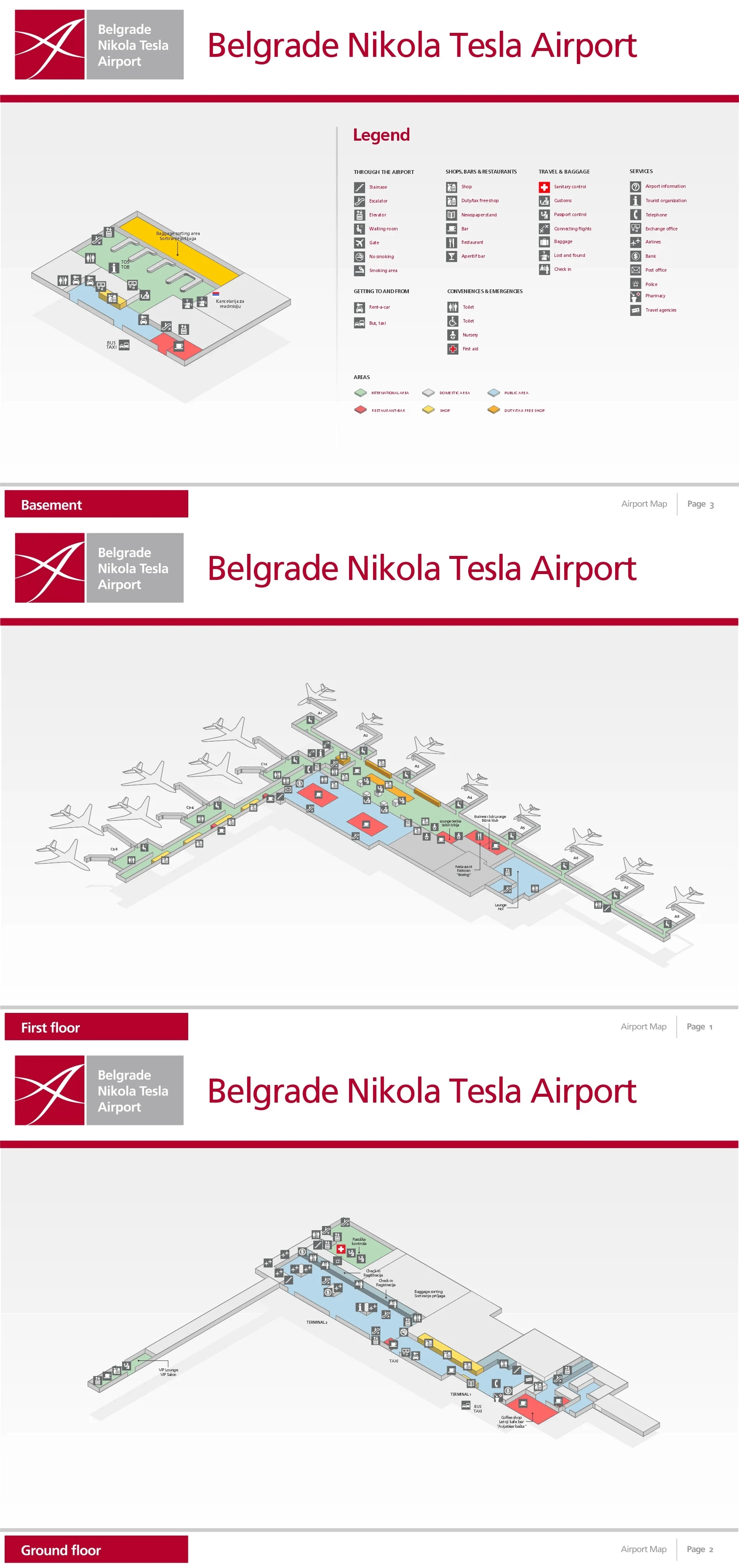
Belgrade Nikola Tesla Airport Terminal 2 Basement Map 2024-2026
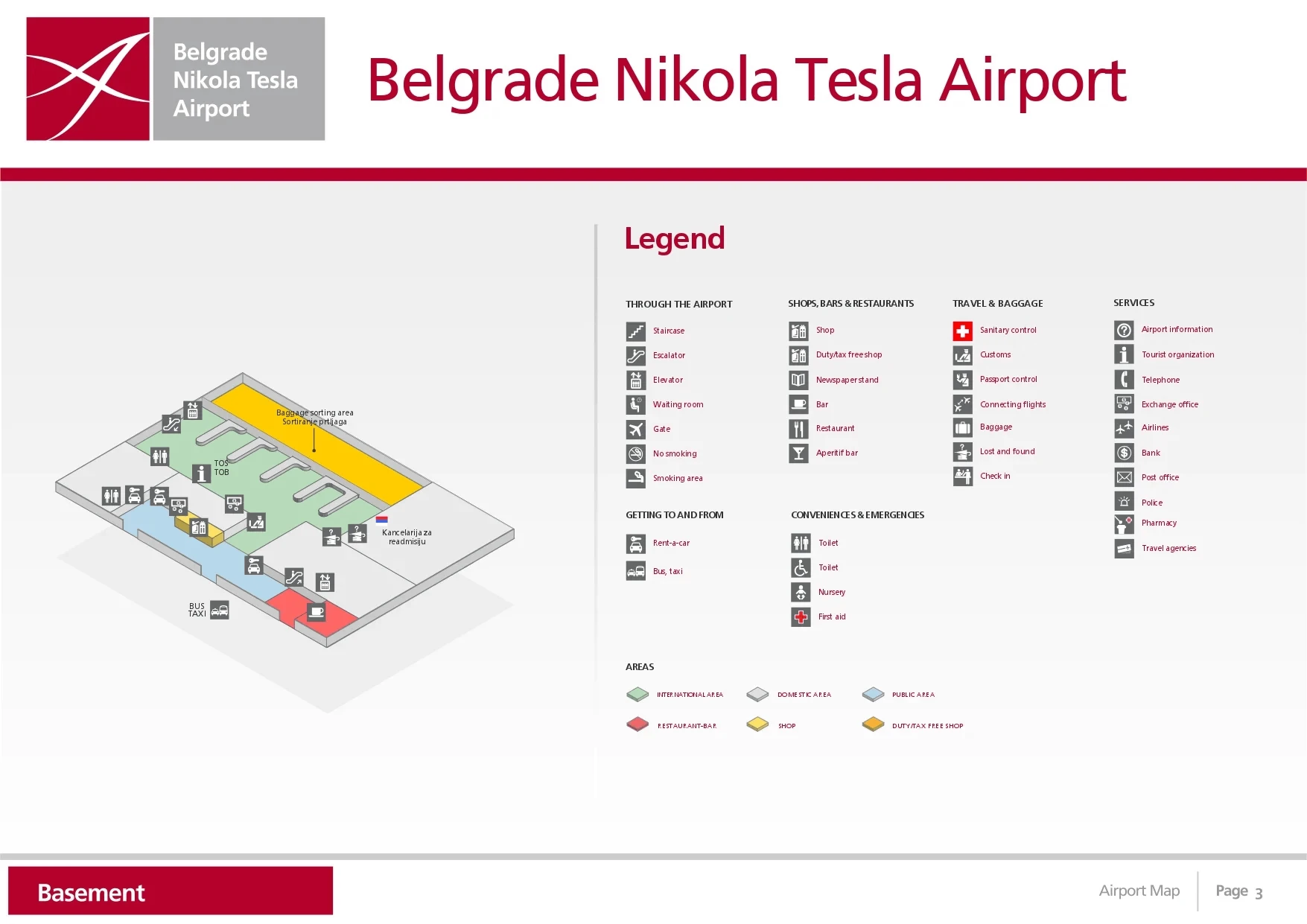
Belgrade Nikola Tesla Airport Terminal 1 First Floor Map 2024-2026
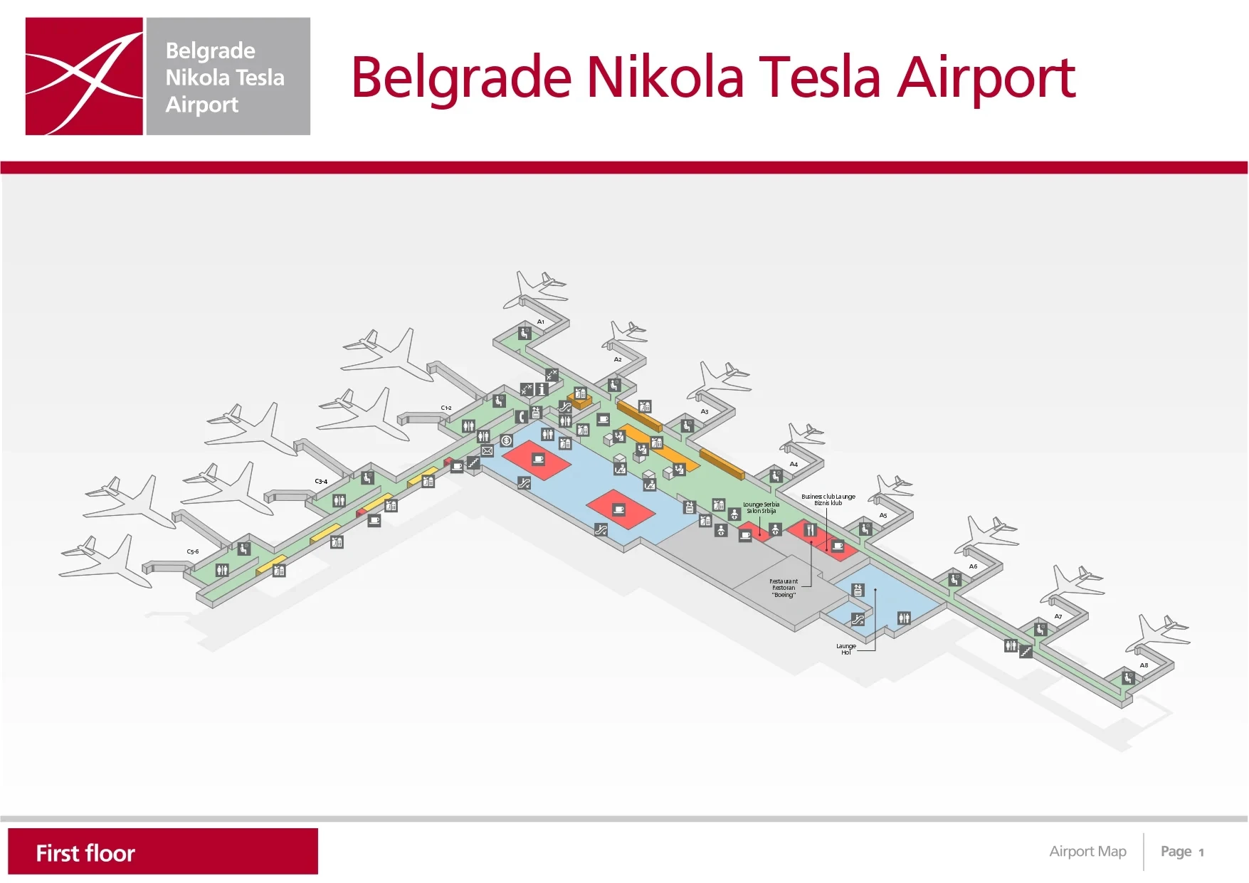
Belgrade Nikola Tesla Airport Terminal 1 Ground Floor Map 2024-2026
2026 Belgrade Nikola Tesla Airport Terminal 2 Map Guide
What is the exact walking distance (meters) from the Terminal 2 check-in counters to the departures passport control queue entrance?
Walking distance is about 100 meters, with the queue entrance effectively beginning at the top of the central escalators/stairs on Level 1. From the far end of the Terminal 2 check-in hall, the horizontal walk typically runs 80–120 meters to the escalator bank, then a short vertical rise (~6–8 meters of elevation) puts you directly into the passport-control queue start zone.
| Start point | End point | Distance (meters) | Map anchor |
|---|---|---|---|
| furthest T2 check-in counters (Ground) | base of central escalators/stairs | 80–120 | “Departures / Gates A & C” overhead signage |
| central escalators/stairs (Ground→Level 1) | passport control queue start (Level 1 landing) | ~0 horizontal + ~6–8 vertical | escalator landing / barrier start |
Where is the single, primary entrance point to the departures passport control area in Terminal 2 (nearest landmark/counter block/escalator shown on the map)?
The primary entrance is the central escalator-and-stair bank rising from the middle of the Terminal 2 check-in hall, with the passport-control queue beginning at the Level 1 landing. Overhead wayfinding typically clusters here with “Departures,” “Gates A,” “Gates C,” and “Passport Control” arrows pointing upward, making this vertical transition the map’s dominant landmark node.
This is a single-funnel design: there isn’t a parallel ground-level entry into international departures processing from Terminal 2. If the queue is heavy, it commonly stacks at the top landing and can spill back toward the escalators, so the escalator landing itself functions as the practical “queue entrance” even before you see the booths.
What is the exact walking distance (meters) from the departures passport control exit to the central security hall entry in Terminal 2?
Walking distance is under 20 meters, because the passport-control exit feeds almost directly into the central security entry. The choke happens in the tiny buffer: passengers are still stowing passports/boarding passes at the passport-control exit while immediately needing to divest for security, so the short distance can still feel slow when queues stack.
Use the passport-control booth exit line as your landmark: once you clear the last booths, the security entrance lanes are essentially straight ahead in the same Level 1 processing core, with no meaningful retail or corridor in between.
Where is the Fast Track / priority lane access point located relative to the standard passport control queue start (left/right, adjacent landmark on the map)?
Fast Track access is adjacent to the standard passport-control queue start at the Level 1 escalator/stair landing, running parallel as a segregated lane beside the main switchback. The entry is positioned at the same decision node where the general queue forms, using barrier separations and signage to split eligible passengers away from the main line.
Relative positioning is easiest to verify by the landmark: stand at the top of the central escalators where the queue barriers begin, then look to the side of the main snake for the dedicated “Fast Track / Priority” channel that bypasses the longest switchback section and feeds forward toward the document-check/podium area.
What is the exact walking distance (meters) from Security exit to the nearest A-gates cluster (first gate sign/portal shown on the map)?
Walking distance is about 50–100 meters from the security exit to the first A-gates portal/signage, because the A-pier begins almost immediately off the duty-free hub. From the security exit, you typically pass directly into the central retail zone; the A-gates direction is the “near” branch off that hub.
The most reliable triangulation is the duty-free exit threshold: once you clear the last retail choke and hit the main airside corridor split, the first A-gate wayfinding (A1–A5) appears within a short straight walk, with gates themselves essentially adjacent to the hub compared to the C-pier.
What is the exact walking distance (meters) from Security exit to the nearest C-gates cluster (first gate sign/portal shown on the map)?
Walking distance is about 150 meters to reach the start of the C-gates corridor from the security exit, because the C-pier branch begins farther from the duty-free hub than the A-pier. The first clear C-gate portal/signage typically appears after you traverse the central retail zone and commit to the C-pier direction.
The key landmark is the main airside split at the duty-free hub: from the security exit, follow the “Gates C” wayfinding through the hub, then continue until the corridor narrows into the C-pier spine. Past that point, distances expand rapidly toward the C-extension (up to ~800+ meters to the far end), but the first C-cluster entry is the ~150-meter decision-to-portal walk.
Where is the Business Club lounge located on the Terminal 2 airside map (identify the gate reference and the turn direction after passport control)?
The Business Club lounge is in the Terminal 2 airside A-pier area near Gate A4, reached by turning right toward A-gates after you clear passport control and central security into the duty-free hub. From the duty-free exit point, keep to the A-gates side of the main pier corridor; the lounge entrance sits along the right-hand side of that A-pier run.
This lounge is close to the A4/A5 neighborhood, so use the first A-gate numbering cluster as your anchor: once A1–A5 signage appears, continue toward the A4 marker and watch for “Business Club” branding on the corridor frontage rather than heading down the longer C-pier spine.
Where is the bus-gate boarding point (remote stand bus departure) located relative to the main pier corridor in Terminal 2 (map landmark)?
The bus-gate boarding point is on a lower level reached by descending from the main airside pier corridor via stairs or an escalator into a ground-level holding area. The map landmark is the “vertical descent” node in the pier: instead of staying on the Level 1 corridor that serves jetway gates, you follow signage for the bus gates (commonly labeled with suffixes like A7a/A7b or C10a–e) to a down-going stair/escalator.
This is a timing trap: the boarding process adds a descent step plus bus transit to a remote stand. If your boarding pass shows a bus-gate suffix, plan for the extra vertical movement before the holding pen, then the apron-bus loading area immediately after that descent.
What is the exact walking distance (meters) from Arrivals baggage claim to the official taxi information/voucher point (the decision node that reduces scam exposure)?
Walking distance is 0–15 meters, because the official Taxi Info / voucher counter is located inside the baggage-claim area or immediately adjacent to it at the customs exit into the arrivals hall. The decision node is essentially “at reclaim,” not out at the curb, so you lock in the fixed-fare voucher before you enter the public meeting area and taxi solicitation zone.
Anchor it to baggage belts and the customs channel: look for “Taxi Info” signage near the end of the reclaim flow (by the Green Channel exit), get the printed voucher, then proceed past all solicitors to the official taxi rank outside.
What is the exact walking distance (meters) from Arrivals baggage claim to the designated rideshare/app-car pickup zone (the first clearly marked pickup curb/zone)?
No designated curbside rideshare pickup zone exists at BEG Terminal 2 arrivals, so the “first clearly marked pickup” for app-car meetups is typically the short-term parking garage approach (P1/P2) or an agreed point away from the taxi curb, about 100–300 meters from baggage claim. The practical endpoint is the parking-structure entry/meeting edge rather than the arrivals curb directly in front of the doors.
From baggage claim, your route is: exit customs into the public arrivals hall, continue out the main sliding doors, then walk away from the official taxi line toward the short-term parking area where app drivers can stop without being moved on. The exact meters vary with current enforcement and any active construction routing.
Which terminal exit door number (or named exit) is the shortest path from Arrivals baggage claim to public bus stops (single best exit only)?
The shortest path uses the main International Arrivals exit straight out of the arrivals hall sliding doors to the curb, then left toward the public bus stop area. This is the primary, named exit that dumps you directly onto the curbside interface where the city routes stage, rather than routing you into parking or taxi-voucher workflows.
Triangulate by the curbside landmark: once you step through the main arrivals doors, orient left along the curb/island where GSP public-transport signage and the A1/72 service area is typically located, keeping away from the official taxi queue line directly in front of the doors.
Where is the Terminal 1 ↔ Terminal 2 connecting corridor entrance on the Terminal 2 map (single point of entry, nearest landmark)?
The Terminal 1 ↔ Terminal 2 landside connector entrance is the indoor hallway linking the two check-in halls, accessed from the Terminal 2 check-in area as a signed corridor leading toward Terminal 1. On the map, the nearest landmark is the edge of the Terminal 2 check-in hall footprint where wayfinding begins pointing to “Terminal 1” and the corridor narrows into a straightforward passage.
As a triangulation cue, treat it as a “hall-to-hall” seam: you move away from the central escalator node (departures up-flow) and instead follow landside signage along the check-in frontage toward the adjacent terminal hall, staying indoors the entire time.
What is the exact walking distance (meters) from Transfer desk (airside) to the nearest passport control point used for connecting flows (single direction only)?
Walking distance is about 20–50 meters from the airside Transfer Desk to the nearest connecting-flow passport control point, because both sit in the central transit zone between the A- and C-pier spines. The Transfer Desk functions as a staging node right where transfer passengers converge, so the nearest border-control interface is intentionally close.
Use the central retail/transit hub as the anchor: from the Transfer Desk frontage, follow the nearest “Passport Control / Transfers” wayfinding toward the connecting-processing doorway or booth line, which should appear within a short corridor-length move rather than a pier-level walk.
Where is the nearest ATM to Terminal 2 Arrivals exit on the map (single closest unit only)?
The nearest ATM is immediately inside the public Arrivals hall just after you pass through the customs exit doors, positioned right beside the arrivals exit frontage. From the baggage-claim/customs flow, you step into the landside meeting area and the closest ATM is in the first bank of machines along the wall adjacent to those doors (typically to the immediate right or left).
Use the customs sliding doors as the landmark: as soon as you cross into the public hall, scan the wall line nearest the door bank for the first ATM unit rather than walking out to the curb or into the parking connectors.
Where is the nearest restroom to the start of the departures passport control queue (single closest restroom only)?
The nearest restroom is in the Terminal 2 landside check-in hall on the Ground Floor, used before you ascend the central escalators/stairs toward departures passport control. Once you go up to the Level 1 queue start, there are no accessible restrooms in the immediate passport-control queuing area or in the short buffer between passport control and security.
Anchor it to the decision node: use the check-in hall restroom facilities before committing to the central escalator bank in the middle of the hall, because the escalator landing becomes the practical start of the queue matrix with no easy exit.
Archive Belgrade Nikola Tesla Airport Terminal 2 Map
Below are all historical map versions for Belgrade Nikola Tesla Airport. Each year includes the official map available for that period, presented as both WebP and PDF.
2024-2026 Belgrade Nikola Tesla Airport Terminal 2 Map (Official 2024 Edition)


