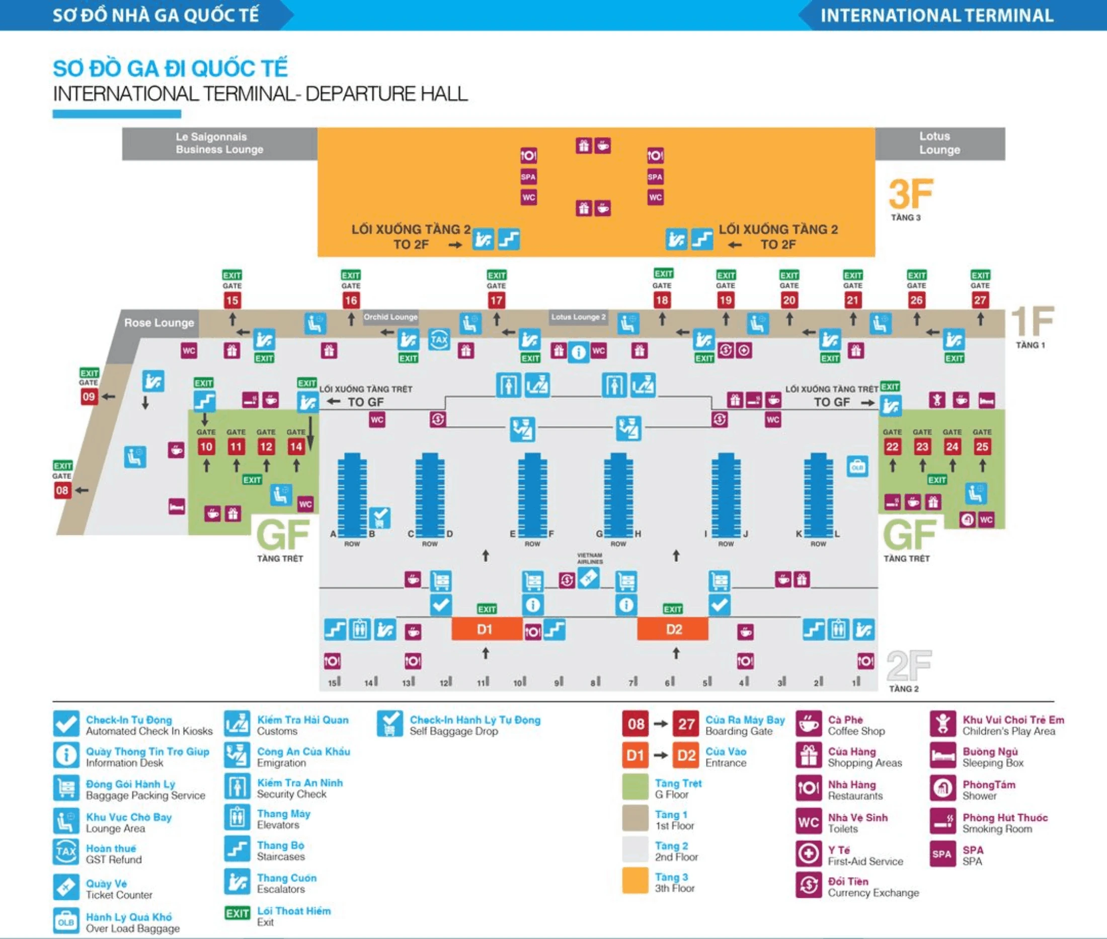
Tan Son Nhat International Airport Terminal 2 Map (most Up-To-Date)
SGN Terminal 2 (International) is a compact, stacked terminal where the real “distance” problem is vertical movement and crowd density, not long corridors. Arrivals funnel up to 1F immigration, then drop down to baggage and customs on the ground floor, while departures concentrate into a central check-in hall that feeds passport control and then security. As part of Ho Chi Minh City’s main airport hub, Terminal 2’s key orientation is curbside doors (A1/A2) and Column 12 for shuttles and buses.
Map Table
| Zone | Connection | Walk Time |
|---|---|---|
| Arrivals Hall (GF) | Doors A1/A2 | crowd pinchpoint |
| Immigration Hall (1F) | Visa on Arrival counters | queue origin |
| Shuttle / Bus Stop | Column 12 | 1–2 min from A1/A2 |
| Ride-hailing | International Arrival Parking Lot | 3–5 min from A1/A2 |
Tan Son Nhat International Airport Terminal 2 Map Strategy
- Treat immigration and security as time-variance traps, not fixed steps; navigate by where the queue starts (VOA area on 1F) rather than where the desks are.
- Lock in hard anchors before you land: arrivals exit doors A1/A2, Column 12 for shuttles/buses, and the escalator bank that feeds 1F immigration from remote-stand bus entry.
- If using fast-track/VIP, aim for the real handoff geometry: gate/airbridge first, then the open floor area before VOA at the 1F immigration hall entrance for remote-stand scenarios.
- Minimize transfer friction by choosing the correct mode: walk T2↔T1 via the covered walkway; shuttle T2↔T3 only, and budget road-traffic and wait-time variability into the plan.
2026 Tan Son Nhat International Airport Terminal 2 Map + Printable PDF
Current 2026 operations at SGN Terminal 2 still behave like a chokepoint system: remote-stand arrivals can inject a 15–22 minute “hidden” delay before you even reach immigration, and peak-hour queues can back up to the Visa on Arrival area. The printable map focus is anchor-verified: where lines actually begin, where escalators throttle flow, and where Column 12 shuttles and buses physically stop curbside.
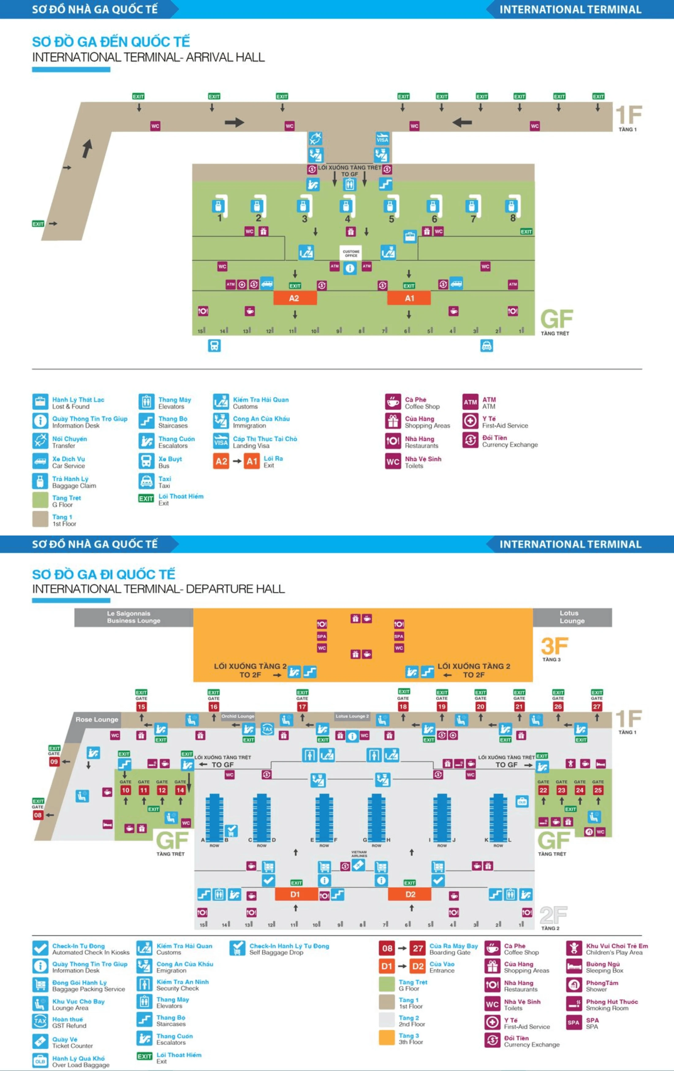
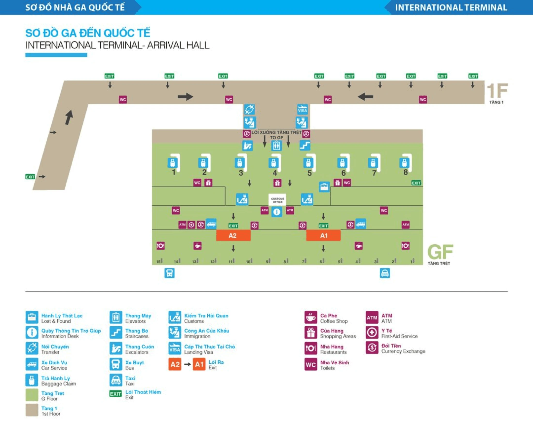
Tan Son Nhat International Airport Terminal 2 International Arrival Map 2024-2026
Tan Son Nhat International Airport Terminal 2 International Departure Map 2024-2026
2026 Tan Son Nhat International Airport Terminal 2 Map Guide
What is the exact walking route and distance from T2 Arrivals exit to the domestic transfer / terminal shuttle pickup point (include door numbers/curb zone if labeled)?
Walking runs about 30–50 meters from SGN T2 Arrivals exit doors A1/A2 to the inter-terminal shuttle pickup at Column 12. Exit customs into the Ground Floor Arrivals Hall, go out through Door A1 or Door A2 to the curb, then turn right along the curbside until the column marker “12” (sometimes paired with “Bus Station/Shuttle Bus” signage) comes into view.
Use Column 12 as the fixed visual target, not “in front of the terminal.” If you hit the taxi queues and official curb pickup immediately outside A1/A2, you’re still close—stay curbside and continue right to the Column 12 post where buses stage.
Where is the physical start of the arrivals immigration queue in T2 (the point where the line begins to form at peak times)?
The arrivals immigration queue physically begins at the Visa on Arrival (VOA) counter area inside SGN T2’s Level 1 Immigration Hall during peak loads. When volume surges, the tail of the line retrogrades away from the passport desks and forms a dense blob beside and in front of the VOA counters on the side of the main hall entry.
From the corridor/escalator approach into the 1F hall, the VOA counters act as the choke landmark where flowing passengers and stationary VOA users collide. If you already have clearance to use the regular lanes, bypass the VOA crowd by moving toward the center/right side of the hall to locate the stanchioned passport-control lines rather than stopping at the first mass of people.
Where are the fast-track/VIP meet-and-greet handoff points located for arrivals in T2 (exact doorway/column/signage landmark)?
Fast-track/VIP meet-and-greet handoff happens either at the aircraft arrival point or at the Immigration Hall entrance on Level 1, depending on whether you arrive by airbridge or remote stand. For contact-gate arrivals, staff typically meet you at the gate/airbridge exit holding a name board as you step into the terminal flow.
For remote-stand arrivals, the reliable indoor landmark is the open floor area immediately before the Visa on Arrival counters at the 1F Immigration Hall entry, where staff congregate with name signs just ahead of the stanchioned immigration lanes. If you come up from the bus-drop ground-level entry via the dedicated escalators, look for the name-board cluster before the VOA zone rather than pushing deep toward the passport desks.
What is the walking distance from the end of arrivals immigration to the first baggage belt area (time cost once cleared)?
Walking from the end of arrivals immigration to the first baggage belt area is roughly 50–80 meters and typically takes about 2–3 minutes once cleared. After the passport-control desks on Level 1, you move a short distance to the escalator/elevator bank, descend to the Ground Floor, then walk forward into the first carousel zone.
The key anchor is the escalator bank immediately after immigration: it sits about 10–20 meters from the desk line. From the bottom of the escalator, the first belts appear quickly—around 20–30 meters—so the only meaningful time add is vertical movement and pedestrian congestion at the landing.
Where is the international departures immigration entry point relative to check-in counters in T2 (exact corridor/level/landmark where the queue begins)?
International departures immigration entry is centrally positioned behind the check-in rows on SGN T2’s Departures Level and begins in the main circulation space between the check-in counters and the rear glass-partitioned immigration frontage. After completing check-in at your assigned row (A–L), you walk into the central aisle toward the middle-back of the hall, where the passport-control entry and stanchions start forming the queue.
At peak times, the tail of the line often spills outward into the open floor area between the check-in rows and the immigration wall, so the “queue begins” is frequently not at the doorway itself but in the central corridor that runs behind the middle block of counters.
Which specific security checkpoint lanes in T2 tend to become the bottleneck (identify their exact location on the departures map, not “security in general”)?
The general/economy security lanes immediately after departures immigration are the consistent bottleneck, while the priority/fast-track lane off to one side is the main bypass. SGN T2’s constrained throughput comes from standard divestment (liquids/laptops) across the main bank of lanes rather than one uniquely “bad” numbered lane.
On the departures flow, security sits directly behind passport control: once you clear immigration, follow the channel straight into the screening area and you’ll see the main cluster of general lanes taking most passengers. If you have eligibility or a purchased fast-track service, look for the dedicated priority lane positioned along the edge of that same security bank (commonly at the far left or far right depending on the day’s configuration).
Where is the earliest point landside a passenger can physically queue to be “front of line” before check-in opens, and how close is it to the check-in row entrances?
The earliest physical “front of line” position is at the head of your assigned check-in row (A–L) on the departures level, right where the stanchion opening meets the row entrance. SGN T2 does not provide a separate pre-queue pen, so being first means standing at the row mouth rather than waiting in a central holding area.
Before counters open (commonly around 3 hours before departure), passengers cluster in the general circulation space near their row and then compress into a single-file start at the row entrance. The distance from that staging spot to the first check-in desk position is essentially 1–3 meters—once the line forms, you’re already at the row’s front edge.
What is the exact route from a remote-stand arrivals bus drop-off to the immigration hall entrance inside T2 (the path that adds the 15–20 minute variable)?
The remote-stand dealbreaker is the forced bus-to-building-to-escalator path, which adds about 15–22 minutes before you even reach the 1F immigration hall. From the aircraft, you board the apron bus, ride to the terminal, and disembark at the Ground Floor bus-gate entry through glass doors into the controlled arrival funnel.
From that ground-level entry, go straight to the dedicated escalator/stair bank located immediately inside the bus-drop zone and ride up to Level 1. At the top landing, follow the short connector corridor into the Immigration Hall, emerging into the open floor area just before the Visa on Arrival counters—this is the effective “immigration hall entrance” where queues and fast-track meet points become visible.
Where is the T2 exit point used to reach Grab/ride-hailing pickup (exact curb/door area), and how far is it from the main arrivals doors?
Grab/ride-hailing pickup is reached via the Ground Floor arrivals exits at Doors A1/A2, then across to the International Arrival Parking Lot. Exit into the Arrivals Hall, go out through Door A1 or Door A2 to curbside, and use the zebra crossing directly in front of those doors to cross the access road into the parking area where ride-hailing/“tech taxi” signage is posted.
The walk is about 50–80 meters from the A1/A2 doorway line to the pickup stand area. A practical landmark along the path is the nearby “Lucky Cafe & Fast Food” area referenced as part of the approach into the parking island, and the biggest variable is weather exposure on the crossing.
Where are the terminal-to-terminal shuttle bus boarding locations when traveling from Terminal 3 to Terminal 2 (exact stop position, not just “in front of the terminal”)?
Terminal 3 to Terminal 2 shuttle boarding is on Terminal 3’s Ground Floor at Columns 18A and 19A. Waiting on Terminal 3’s Arrivals level (2nd floor) is the common failure mode because the shuttle does not reliably serve that level for the T2 run.
From inside T3, route yourself down to Ground, then walk curbside until you see the column markers “18A” and “19A,” where the inter-terminal shuttle stages. Treat the column numbers as the boarding proof; if you don’t see 18A/19A, you’re on the wrong side or wrong level.
Where is the shortest on-foot path between Terminal 2 and Terminal 1 (if walkable), and what is the measured distance end-to-end?
The shortest on-foot path is the covered walkway connection between SGN Terminal 2 (International) and Terminal 1 (Domestic), measured at roughly 200 meters end-to-end and about a 5–7 minute walk with luggage. Exit Terminal 2 at the Ground Floor arrivals curbside area, then follow signage for “Domestic Terminal” / “T1” onto the roofed, open-air pedestrian connector.
The practical endpoints are the T2 arrivals-side exit zone and the T1 entrance-side curb frontage, not a center-to-center terminal measure. The walkway is generally trolley-friendly and protected from rain overhead, but it is open to heat and humidity, so pace and crowding can shift the time more than the distance does.
Where are the queue overflow areas located when departures immigration “spills out” beyond lanes (identify the exact spill zone on the T2 departures layout)?
Departures immigration overflow occupies the main circulation space between the check-in rows and the immigration glass partition on SGN T2’s departures level. When the stanchioned lanes reach capacity, the tail extends outward into the central aisle behind the middle block of check-in counters, then spreads laterally across the passenger cross-flows.
The spill zone is the open floor directly in front of the immigration frontage, where passengers finishing check-in must normally pass to reach passport control. During peaks (Tet and summer surges), temporary stanchions often create a snaking line that blocks the through-path between check-in rows, so the “overflow” is effectively the central corridor itself rather than a separate holding room.
Archive Tan Son Nhat International Airport Terminal 2 Map
Below are all historical map versions for Tan Son Nhat International Airport. Each year includes the official map available for that period, presented as both WebP and PDF.
2024-2026 Tan Son Nhat International Airport Terminal 2 International Map (Official 2024 Edition)