Tocumen International Airport Terminal 2 Map (Most Up-To-Date)
Tocumen Terminal 2 (PTY T2) is a long, linear “wing” anchored by a central “spaceship” hub that feeds two extended gate piers, so distances feel bigger than the building looks at first glance. Set within Panama City’s primary aviation hub, Terminal 2 connects to Terminal 1 via an enclosed airside corridor, but most “missed connection” risk comes from the long approaches inside each terminal, not the bridge itself. Expect vertical level changes (Arrivals 100, Gates 200, Services 300) to shape every route.
Map Table
| Level | Gate range | Key landmarks | Connection |
|---|---|---|---|
| 100 | Arrivals flow | Immigration, baggage claim, landside exits | Uber path to Parking P17–P18 |
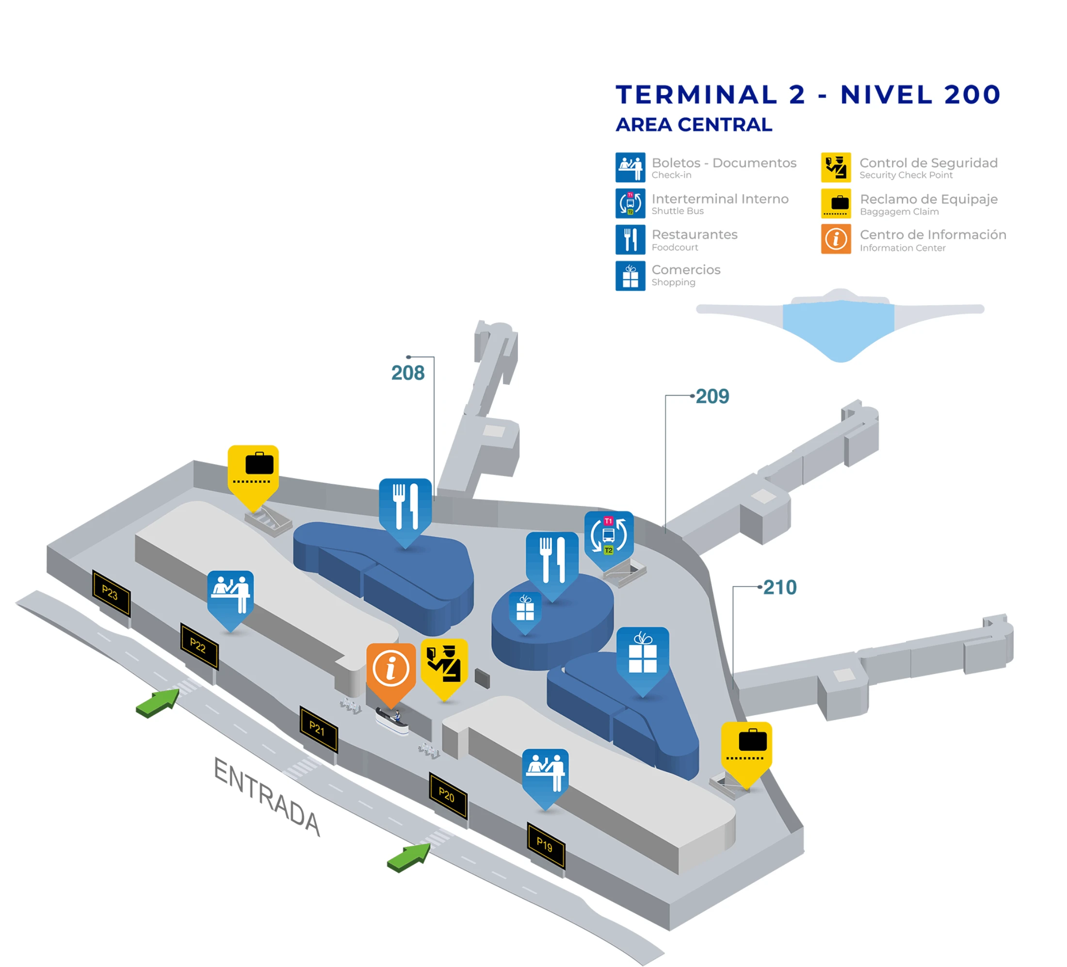
| 200 | 201–225 | “Spaceship” hub, Guy Fieri’s, Popeye’s queues | Airside T1↔T2 corridor |
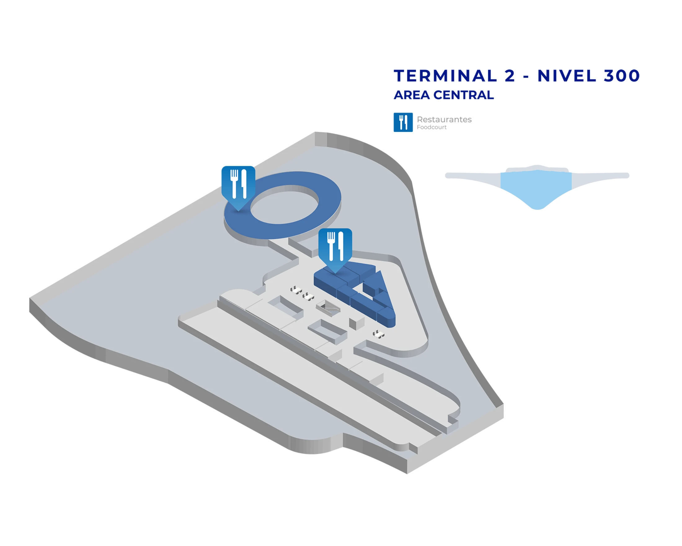
| 300 | Lounge/services | Copa Club access point | Up near Gate 208 |
Tocumen International Airport Terminal 2 Map Strategy
- Treat the “172-meter connector” as only the bridge segment; plan for 15–25 minutes gate-to-gate when a terminal switch is involved, especially if moving walkways are down.
- Lock onto the central “spaceship” hub as your reset point: if you’re lost, backtrack to the hub zone near Gates 201–204, then re-branch toward Gate 208 (lounge) or toward the T1 corridor.
- Assume U.S.-bound gates can impose secondary screening at the gate area; avoid buying liquids right before walking to a U.S. departure gate.
- For pickups, do not wait curbside expecting rideshare; Door 17 is a reference exit that pushes you toward the parking structure meeting zone (Columns P17–P18), and the Metro entrance is found by walking toward the connector/T1 direction rather than “out” of the terminal.
2026 Tocumen International Airport Terminal 2 Map + Printable PDF
Operational layout and wayfinding in 2026 still hinge on the same friction points: long pier walks, vertical transitions between Levels 100/200/300, and the airside T1↔T2 connector that’s short in meters but long in total travel time once you include terminal approaches. U.S.-bound departures also add a gate-area screening step that can slow boarding and invalidate liquids bought airside.
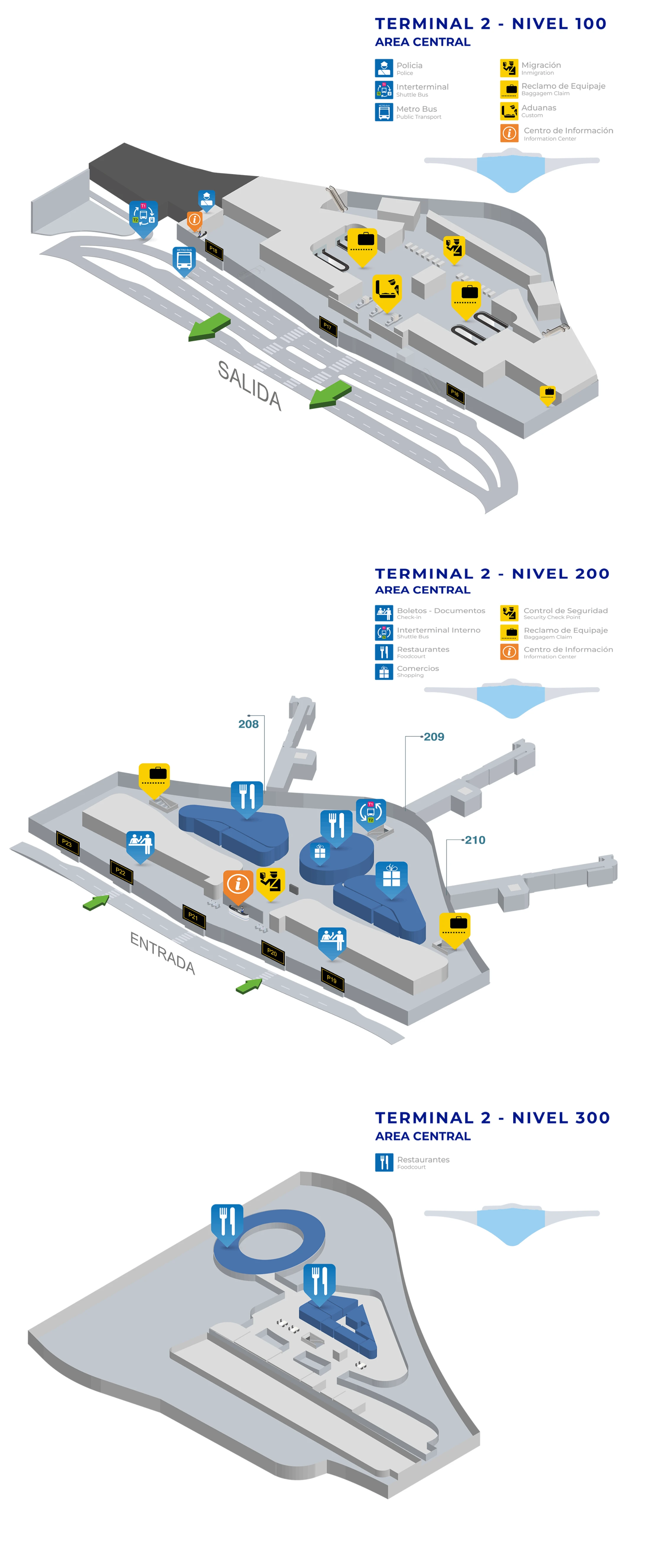
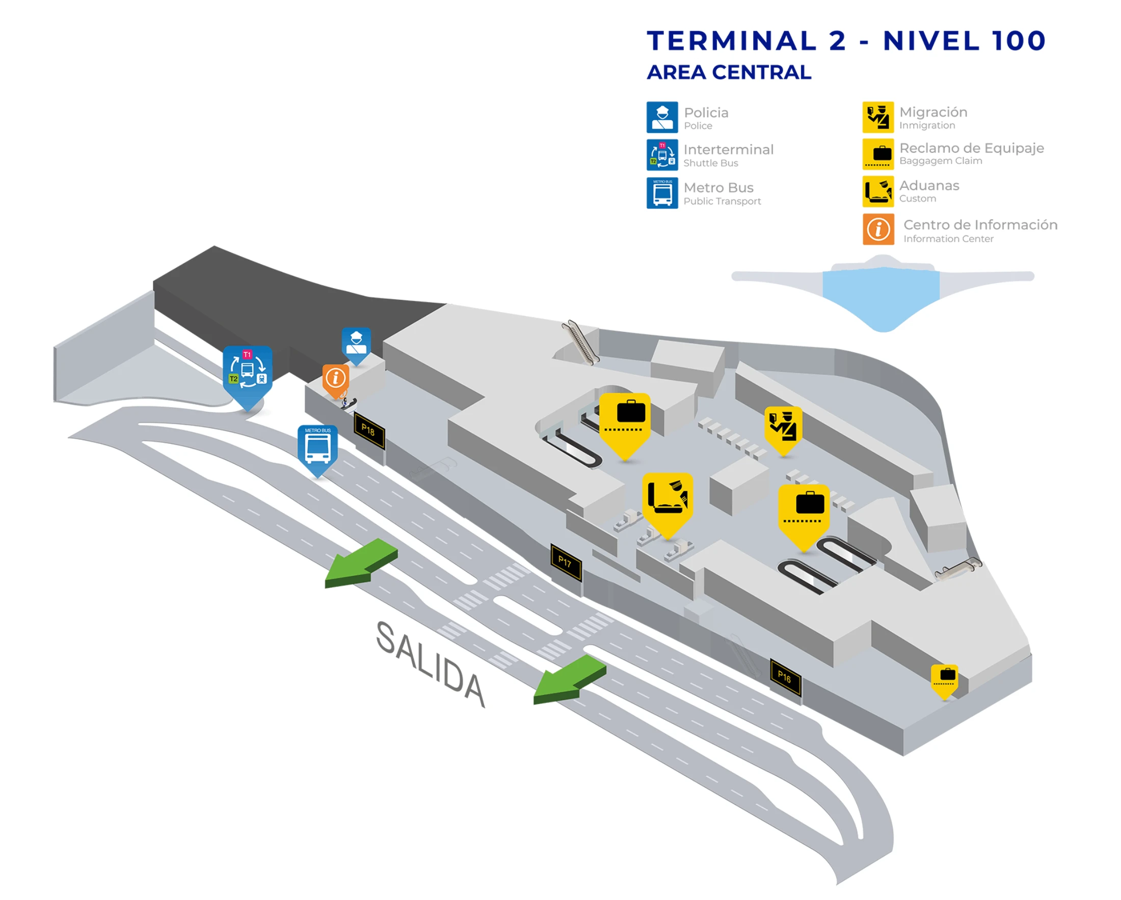
Tocumen International Airport Terminal 2 Nivel 100 Map 2026
Tocumen International Airport Terminal 2 Nivel 200 Map 2026
Tocumen International Airport Terminal 2 Nivel 300 Map 2026
2026 Tocumen International Airport Terminal 2 Map Guide
What is the exact walking route and distance (meters) from T2 international arrivals exit to the airside corridor entrance for the T2 → T1 connection?
The airside corridor entrance is not reachable from the Terminal 2 international arrivals landside exit without re-entering the secure departures flow. Terminal 2 arrivals (Level 100) dumps you into immigration/baggage claim/ground-transport routing, while the T2→T1 connector is an airside feature aligned with the Level 200 gate spine near the central “spaceship” hub.
To reach the connector entrance after arriving, the practical route is to stay airside only if you are a true transit passenger and follow “Connecting Flights / Terminal 1” toward the hub area near Gates 201–204; if you go down to immigration/baggage claim and exit, you must transition back up into departures security to regain airside access before you can enter the T1↔T2 corridor.
Where is the T1↔T2 airside connection point located by named landmarks (e.g., “Connector,” “Bridge,” “Corridor”) on the terminal map?
The T1↔T2 airside connection point sits at the Terminal 2 central “spaceship” hub edge, where the main Level 200 spine meets the enclosed connector corridor toward Terminal 1. On the Terminal 1 side, it lands by the 100-series gate area near Gates 104/105.
The corridor is the glass-walled “bridge” segment people cite as 172 meters, and it’s reached in T2 by walking back from the gate piers toward the hub zone near Gates 201–204. From there, follow the Terminal 1/connector direction (often reinforced by purple-for-T1 vs green-for-T2 wayfinding) until you enter the enclosed corridor with apron views and aircraft visible outside.
What is the exact walking distance from T2 Security to the Copa Club (Terminal 2) entrance using the shortest mapped path?
The Copa Club entrance is positioned above the main concourse via the vertical circulation cluster closest to Gate 208. The shortest practical path runs from the Level 200 post-security spine straight toward the Gate 208 node, then up to Level 300 using the escalator/elevator bank adjacent to that gate area.
From a navigation standpoint, the distance is dominated by how far your security exit point is from the Gate 208 sector: after clearing security, stay on Level 200, follow the main spine toward the 200-series gates until you reach the Gate 208 vicinity, and then take the dedicated escalators/elevators up to the lounge level. The best “triangulation anchor” is Gate 208 itself—if you can see Gate 208 signage, you’re within the final approach to the lounge access point.
Which exact gate zone(s) in T2 have the secondary U.S. flight security checkpoint, and where is it positioned relative to nearby gates?
Secondary U.S.-bound screening happens at the departure gate area, immediately before boarding, rather than at a single centralized checkpoint. The checkpoint is set up as a gate-side queue and inspection table/lanes at whichever T2 gates are assigned to U.S.-destination flights that day.
In practice, this means the “zone” is variable across the 200-series concourse: when a gate is operating a U.S. flight, the screening is positioned right at that gate’s boarding choke point (the last holdroom-to-jet-bridge transition), so the line forms in the seating area directly in front of the gate podium. The most reliable landmark is the gate itself—if your flight is U.S.-bound, plan time for a second stop at the gate and assume liquids bought elsewhere in T2 may be blocked at that final check.
What is the exact location of Door/Exit 17 at Terminal 2 on the map, and what is the shortest walking path from Arrivals to that door?
Door 17 is a landside exit on Terminal 2 Level 100 that functions as the reference point for leaving the arrivals hall toward the parking complex rather than a true curbside rideshare bay. It’s the exit that feeds the pedestrian crossing toward the garage where rideshare meeting is aligned to Columns P17–P18.
From Terminal 2 arrivals, follow the Level 100 flow past baggage claim to the public exits, then walk along the terminal’s landside frontage to Door 17 signage and exit the building. Continue straight across the vehicle lanes via the marked pedestrian crossing and enter the parking structure; once inside, navigate to the P17–P18 column markers, which is the practical “pickup zone” riders and drivers converge on when Door 17 is referenced.
What is the exact walking distance from T2 to the Airport Metro station entrance (and which mapped pedestrian path gets you there)?
The Airport Metro station entrance is reached by walking from Terminal 2 toward the T1↔T2 connector corridor rather than heading straight out to the curb. The usable path runs from T2’s landside/arrivals side toward the internal corridor that links the two terminals, with the station accessed as an appendage off that connector alignment.
In time terms, the walk is typically 5–10 minutes from the T2 arrivals hall to the station entrance, and the critical decision point is choosing “Terminal 1 / Connector” direction first even though you’re trying to leave the airport. Use the central “spaceship” hub alignment as your triangulation: if you can orient yourself to the connector/T1 corridor from that hub, you’re on the correct pedestrian vector for the Metro access.
Where are the shuttle pickup/drop-off points for Terminal 2 marked, and which terminal doors/exits do they align with?
The key airside transfer shuttle pickup in Terminal 2 is positioned down the stairs in front of Gate 209, serving the internal loop that moves transit passengers between terminals without using landside exits. On the Terminal 1 side, the matching pickup/drop-off point is by Gates 104/105.
There are effectively two shuttle concepts travelers mix up: the airside (internal) shuttle anchored to Gate 209 for sterile transfers, and a landside (external) shuttle concept that requires exiting to Level 100 curb areas. If you are connecting airside, anchor on Gate 209 and look for the stair descent immediately in that gate sector; if you have already exited to landside, you’re no longer on the same shuttle pathway and will need to use the public-side curb/transport staging instead of the gate-area shuttle node.
On the official or commonly-circulated terminal map, how do T2 gate numbers (200–220) align with concourse direction—i.e., which way do numbers increase from the main spine?
Gate numbers increase as you move away from the Terminal 2 central “spaceship” hub into the long pier, with the lowest 200-series gates closest to the hub/connector side and higher numbers deeper toward the far end. The practical anchor is the Gate 201/202 area near the hub-side arrival divergence and connector vicinity.
Using landmarks, the concourse direction is: hub zone near Gates 201–204 → mid-pier services and Gate 208 (Copa Club access nearby) → higher-numbered gates continuing outward (up through the 220s) toward the terminal’s distal tip. If you’re walking toward a higher gate number, you are committing to a longer linear walk away from the hub and farther from the T1 connector.
What is the shortest mapped path from the T2 connector corridor exit to Gate 200-area gates (first-open gates cluster), measured in minutes/distance?
The shortest path runs from the connector corridor exit directly into the Terminal 2 Level 200 spine at the central “spaceship” hub edge, then straight along the hub-side concourse toward the first 200-series gates clustered near the entry (Gates 201–204 area). This is the “hub-to-early-gates” vector, not a deep-pier walk.
| Segment | Route | Typical time |
|---|---|---|
| Connector exit → hub node | Step out of enclosed corridor into T2’s main spine | 1–2 min |
| Hub node → early gates | Walk along Level 200 concourse to Gates 201–204 signage | 2–5 min |
If moving walkways are out or crowds stack near food queues, the same short physical distance can feel slower; the congestion hotspots to watch are the commercial anchors immediately after you enter the hub zone.
Where are the nearest restrooms located along the T2→T1 transfer corridor path, and what are the closest “decision points” where travelers commonly take the wrong turn?
Restrooms are clustered in the central transition hub area near the main commercial block and VIP/lounge-adjacent services rather than inside the enclosed 172-meter bridge itself. The most dependable “findable” restroom opportunity is just off the Level 200 hub spine after you leave the gate piers and before you commit into the connector corridor.
Common wrong-turn points happen at two nodes: the hub-side split where arrivals traffic peels off toward “Immigration” down to Level 100, and the connector-direction split where distracted travelers drift deeper into the commercial zone instead of staying on the Terminal 1/connector vector. The best mistake-proofing move is to re-anchor on the “spaceship” hub ceiling zone, then follow Terminal 1/connector guidance (often purple-coded toward T1) until the corridor becomes unmistakably enclosed and glass-walled.
What is the distance from T2 arrivals to the first staffed information/help desk (or equivalent service counter) shown on the map?
The first staffed help point is typically positioned in the Terminal 2 central processing hub area where passenger flows converge, rather than deep in the gate piers. From Level 100 arrivals, the closest “service-counter” opportunity is usually just after you clear into the public arrivals hall zone near the main exits and transport-facing frontage.
In practice, the shortest route is: exit the controlled arrivals corridor into the Level 100 public hall, stay in the central hall area (do not follow curbside flow outward yet), and scan for the staffed counter adjacent to the primary exit doors and queue-managed transport/services zone. If you overshoot into Door-numbered exits, you’ve likely walked past the best chance to get staffed help without backtracking.
What is the distance from Gate 208-area (Copa Club vicinity) to the nearest transfer/connector signage node leading toward Terminal 1?
The nearest connector-direction signage from the Gate 208 area is encountered by walking back along the Level 200 concourse toward the central “spaceship” hub, where the terminal’s main directional wayfinding consolidates. Gate 208 sits in the mid-pier zone, so the first reliable “Terminal 1 / Connector” decision signage appears as you re-enter the hub-side spine rather than at the lounge entrance itself.
Operationally, the shortest path is to leave the Gate 208 node and walk straight toward the hub until you hit the first major overhead sign cluster that splits traffic toward the connector corridor versus deeper gate runs. If you reach the dense commercial anchors (Guy Fieri’s / Popeye’s congestion zone), you’re effectively at the signage-rich hub edge and should already be seeing Terminal 1/connector guidance.
Where exactly is the baggage-claim → landside exit flow in T2 relative to the connector path, to avoid accidentally being routed away from the transfer?
The baggage-claim → landside exit flow is a Level 100 (arrivals) egress stream that pulls you away from the airside connector, while the T1↔T2 connector is a Level 200 (gates) airside corridor accessed near the central “spaceship” hub. Once you commit downstairs into immigration/baggage claim, you’ve left the clean transfer pathway and will need to re-enter departures screening to get back to the connector.
The critical divergence happens near the hub-side gate sector around Gates 201–204: “Immigration” sends you down to Level 100 toward baggage claim and exits, while “Connecting Flights / Terminal 1” keeps you on the airside spine toward the connector corridor. The failure mode is drifting with the crowd down to arrivals when you’re actually connecting—if you see descent escalators and immigration signage, you’re at the point where the transfer route and the landside route split.