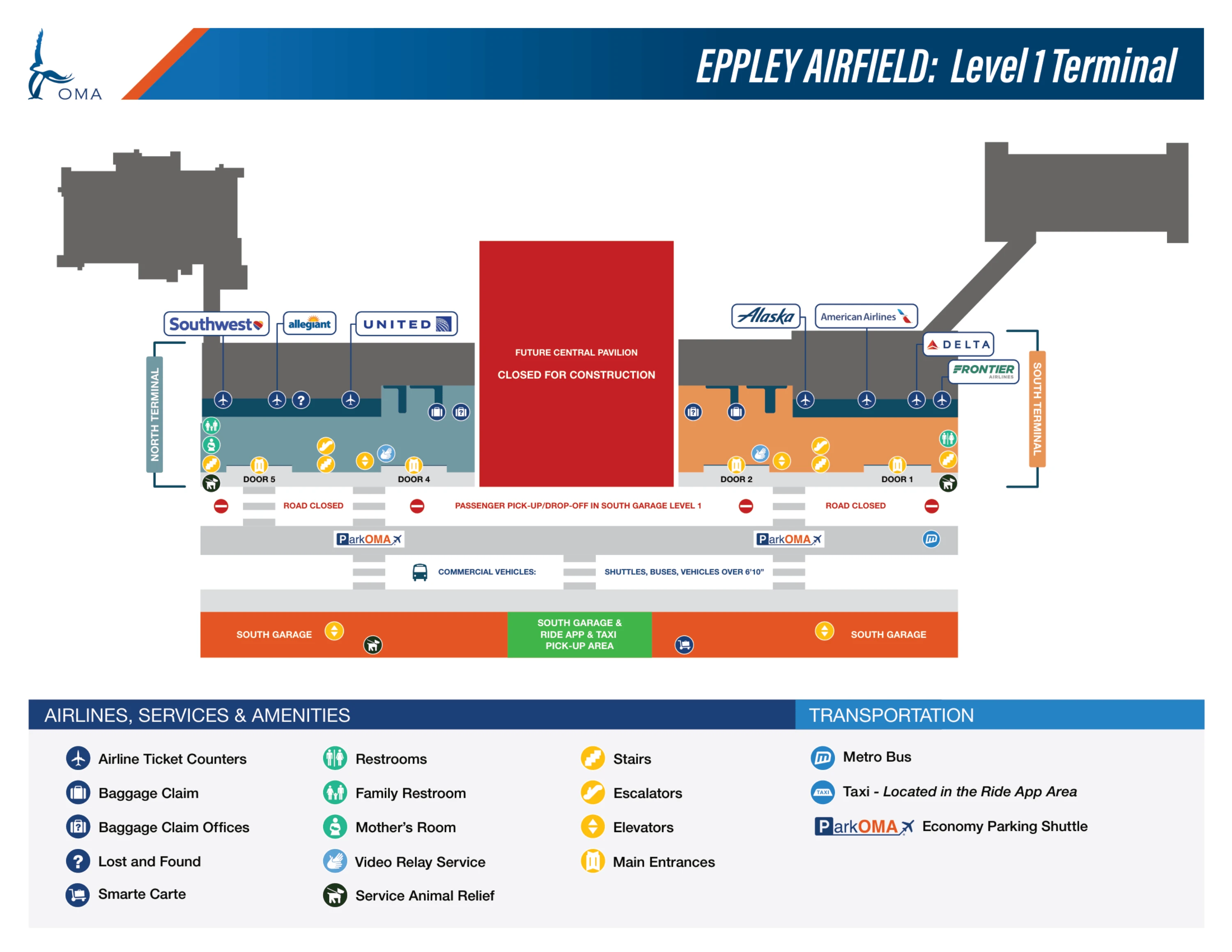
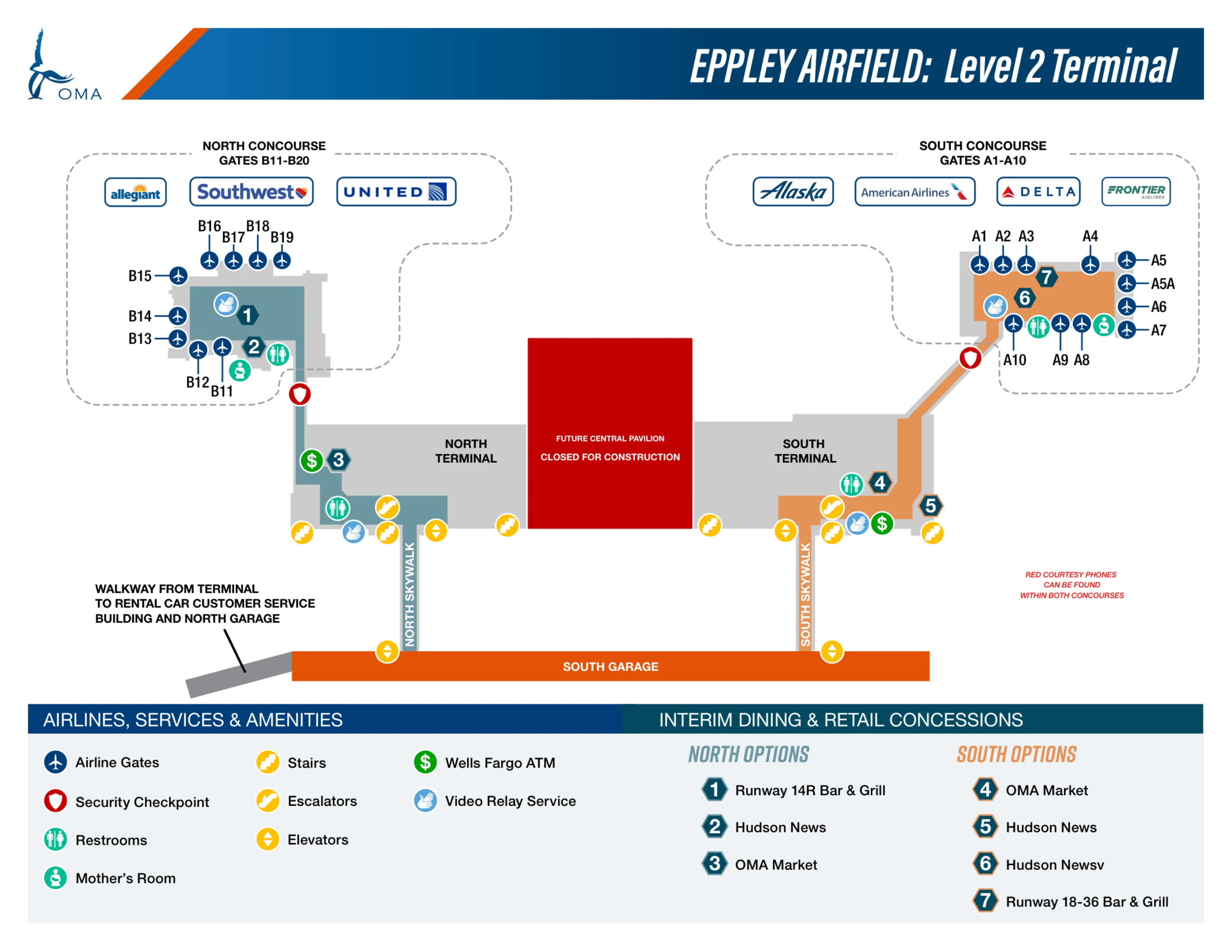
Eppley Airfield North Terminal Map (Most Up-To-Date)
Eppley Airfield’s North Terminal is a construction-phase “island” on the north end of the terminal façade within Omaha’s main airport grounds, with Door 5 as the single working landside entry/exit for North-side airlines. The effective curb is no longer at the terminal glass—ground access collapses into South Garage Level 1, then a short crosswalk gap to Door 5. The footprint runs north–south: Door 5 anchors ticketing/baggage on Level 1, with security and Concourse B directly above on Level 2.
Map Table
| Zone | Connection | Walk Time |
|---|---|---|
| South Garage Level 1 (North lanes) | Crosswalks to Door 5 | 2–4 min |
| Center Median + crosswalk | Garage ↔ Door 5 | 250–350 ft |
| Door 5 (Level 1) | North ticketing + baggage claim | 0–2 min |
| Door 4 shuttle shelter | Door 5 sidewalk route | 1–2 min |
| Ride App pickup (South Garage, D3) | Door 5 → garage → D3 | 4–6 min |
Eppley Airfield North Terminal Map Strategy
- Treat South Garage Level 1 as the curb: the terminal-front roadway is closed, so Door 5 drop-offs and curbside pickups are not physically possible.
- Commit at the overhead gantry after the “TERMINAL SPLIT AHEAD” warning: right-lane signage for Allegiant/Southwest/United positions you closest to the North-side crosswalks.
- Anchor every plan to Door 5 for North: Door 1–Door 3 are wrong for North processing because there’s no indoor connection across the split.
- Pre-plan the two “gotchas”: economy shuttles stop at Door 4 (not Door 5), and Uber/Lyft pickup is South Garage Level 1, Section D3 (far southwest), not at any terminal curb.
2026 Eppley Airfield North Terminal Map + Printable PDF
Construction-phase wayfinding remains defined by the Terminal Split, with Door 5 functioning as the North side’s only reliable public entry/exit and the South Garage Level 1 acting as the consolidated drop-off environment. Expect routing that forces a garage stop plus an outdoor crosswalk, plus geofenced Ride App pickup in a distant garage section and shuttle stops that do not serve Door 5 directly.
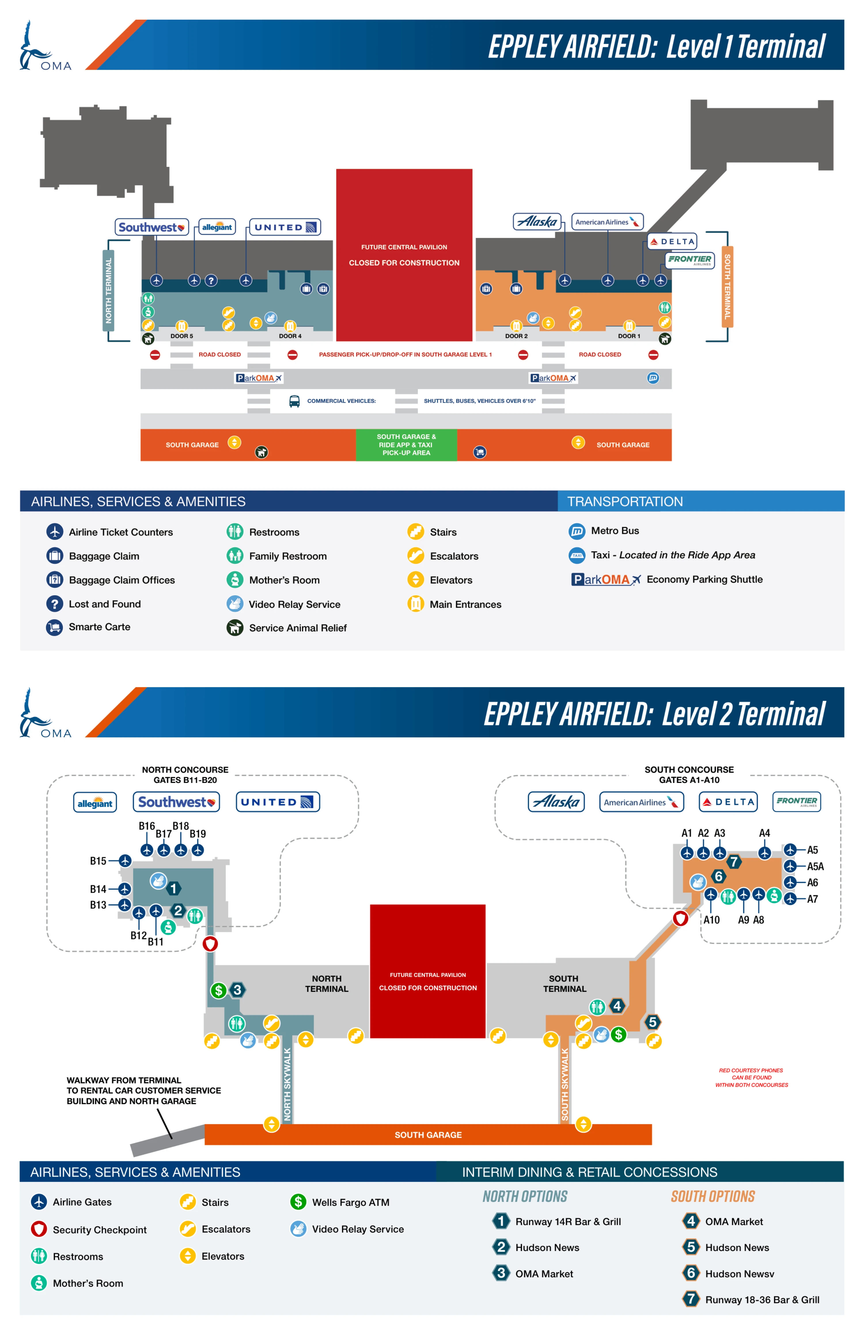
Eppley Airfield North Terminal Level 1 Map 2025-2026
Eppley Airfield North Terminal Level 2 Map 2025-2026
2026 Eppley Airfield North Terminal Map Guide
What is the exact decision point (landmark/sign) where drivers must choose left for North Terminal vs right for South Terminal on the current drop-off approach route?
The decision point is the overhead green gantry sign split immediately after the yellow “TERMINAL SPLIT AHEAD” warning sign on Abbott Drive. Drivers should treat the gantry as the commit point: the right-lane set is signed for Allegiant/Southwest/United (North Terminal), while the left-lane set is signed for Alaska/American/Delta/Frontier (South Terminal).
| Approach node | What to look for | Correct lane choice |
|---|---|---|
| Abbott Drive shoulder | Yellow diamond “TERMINAL SPLIT AHEAD” | Get ready to sort by airline |
| Overhead gantry at lane fork | Green signs listing airlines by terminal | Right lanes = North (Allegiant/Southwest/United); Left lanes = South (Alaska/American/Delta/Frontier) |
What is the exact walking distance (feet/meters) from the North Terminal curb drop-off to the North Terminal ticket counters?
Walking is approximately 250–350 feet (75–100 meters) from the effective drop-off point to the North Terminal ticket counters. The “curb” is South Garage Level 1 (North drop-off lanes), not the terminal-front roadway, because the North terminal curb lane is closed during the split.
| Start point | Route anchors | Distance |
|---|---|---|
| South Garage Level 1 (North drop-off lanes) | garage lane → center median → marked crosswalk → Door 5 → ticketing line | ~250–350 ft / ~75–100 m |
Where is the economy parking shuttle pick-up shelter located relative to the North Terminal entrance doors (which door number/side), and what is the shortest path between them?
The economy parking shuttle pick-up shelter is at Door 4, south of the North Terminal’s Door 5. The shortest path is an outdoor sidewalk walk that starts at Door 5 and moves south to the Door 4 shelter; there is no shuttle stop at Door 5 during the Terminal Split.
- Exit the North Terminal at Door 5.
- Turn right (walk south along the terminal sidewalk/commercial lane).
- Continue about 150 feet to the marked Door 4 shelter area for ParkOMA economy shuttles.
Where do the parking shuttles unload for North Terminal access—what exact curb zone/door do they use?
Parking shuttles unload at Door 4 for North Terminal access, not at Door 5. Door 5 is the North-side anchor for ticketing and baggage claim, but the shuttle stop alignment is one door south during the construction split.
- Target unload location: Door 4 curb/shelter area.
- North Terminal access path: Door 4 → walk north along the sidewalk → Door 5 for North ticketing/baggage claim.
- Not possible: shuttle unloading directly at Door 5.
Where is the Ride App (Uber/Lyft) pickup physically located (garage + level + section), and what is the shortest walking route from the North Terminal exit to that pickup point?
Ride App pickup is in the South Garage, Ground Floor (Level 1), Section D3. The shortest route starts at Door 5, crosses into the South Garage via the marked crosswalk, then continues through the garage pedestrian lanes south and west to the far southwest corner where D3 is signed.
| Segment | Landmark anchors | Typical metric |
|---|---|---|
| Door 5 → garage entry | Door 5 exit → crosswalk → center median → South Garage Level 1 | ~100 ft |
| Garage entry → D3 | North garage side → walk south toward South Terminal side → turn west toward back of garage → Section D3 | ~900–1,100 ft |
| Total | Door 5 → South Garage Level 1, D3 | ~1,000–1,200 ft (300–360 m), ~4–6 min |
What is the shortest walking route from North Terminal baggage claim to the Ride App pickup area, including the exact garage entry point?
Walking is fastest by exiting baggage claim at Door 5 and using the marked crosswalks into South Garage Level 1, then continuing through the garage to Section D3. The garage entry point is the South Garage ground floor entrance reached immediately after the center-median crosswalk from Door 5.
- From North baggage claim (Carousels 4–6), walk to the Door 5 exit doors.
- Exit at Door 5, then go straight to the marked crosswalk leading to the center median and into South Garage Level 1.
- Enter South Garage Level 1 on the north side of the garage, then walk south through pedestrian lanes and continue west toward the back of the structure to Section D3 (Ride App pickup).
Which baggage claim carousel numbers are assigned to North Terminal arrivals, and where are those carousels positioned relative to the North Terminal exit doors?
North Terminal arrivals use baggage claim Carousels 4, 5, and 6, positioned in the north-end baggage claim area by Door 5. Door 5 is also the primary landside exit for North arrivals, so the carousels sit in the same North lobby zone that funnels directly to the Door 5 doors and the crosswalks to South Garage Level 1.
- Assigned to North arrivals: Carousels 4, 5, 6.
- Positioning anchor: North end of Level 1 baggage claim adjacent to Door 5 exit.
- Common failure mode: entering via Door 1 (South side) blocks access to these carousels due to the construction wall.
What is the exact walking distance from Gate area (North Concourse B) to the North Terminal baggage claim carousels (fastest route)?
Walking is about 900–1,400 feet (275–425 meters) from Concourse B gates to North baggage claim (Carousels 4–6), depending on your gate. The fastest route runs straight back to the North checkpoint area, then down the main vertical core to Level 1, landing in the North lobby by Door 5 and the Carousel 4–6 zone.
| Start gate zone | Fastest route anchors | Typical distance |
|---|---|---|
| Near B11 (closest end) | gate area → checkpoint exit corridor → main escalators/elevators → Level 1 North lobby → Carousels 4–6 (by Door 5) | ~900–1,100 ft (275–335 m) |
| Near B19 (furthest active end) | gate area → walk past the B15 restroom area toward checkpoint → main escalators/elevators → Level 1 North lobby → Carousels 4–6 (by Door 5) | ~1,200–1,400 ft (365–425 m) |
Where is the North Terminal security checkpoint entrance located relative to the North ticket counters, and what is the shortest path between them?
The North security checkpoint entrance is on Level 2 directly above the North ticketing lobby and reached via the central vertical core beside the ticket counters. The shortest path is to finish at the counters on Level 1, then move immediately to the adjacent escalators/elevators/stairs and ascend to Level 2, where the checkpoint feeds straight into Concourse B.
- From the North ticket counters (inside Door 5), walk to the central escalator/elevator/stair bank in the same lobby.
- Go up one level to Level 2.
- Follow the short corridor to the North security checkpoint entrance.
If the North side security queue overflows, what is the physical spillover corridor/area (the exact place the line snakes into)?
Overflow lines snake into the corridor by the North Skywalk entrance on Level 2. The queue backs out of the checkpoint area and extends into the hallway leading toward the parking garage skywalk and the upper-level vertical core, using landmarks like the frosted-glass door area and the ADA gate as the recognizable “line starts here” edge.
- Spillover corridor: Level 2 hallway adjacent to the North Skywalk entrance.
- Visual anchors: frosted-glass door area and the ADA gate near the checkpoint approach.
- Negative constraint: clearing South security does not help, because there’s no post-security crossover to Concourse B.
Where is the service animal relief area outside the North Terminal (relative to door number/curb zone), and what is the shortest path to reach it from the North ticketing doors?
The service animal relief area is outside the North Terminal just north of Door 5. The shortest path is to exit the ticketing lobby through Door 5, turn left (north), and walk past the end of the building façade to the relief zone.
- Start: North ticketing doors inside the Door 5 lobby.
- Exit: go out through Door 5.
- Direction: turn left (north) along the exterior sidewalk.
- Location anchor: immediately north of Door 5 near the end of the North façade.
- Dealbreaker: no airside relief area exists in Concourse B, so use this before clearing security.
Where are the rental car counters located (which building/connector from North Terminal), and what is the shortest indoor route from North baggage claim to those counters?
Rental car counters are in the Customer Service Building connected via the North Skywalk to the North Garage. The shortest indoor route starts in North baggage claim on Level 1, goes up to Level 2 at the main vertical core, then crosses the enclosed North Skywalk and takes the first right into the connector corridor into the Customer Service Building.
- From North baggage claim (Carousels 4–6 by Door 5), go to the nearby elevators/escalators.
- Ascend to Level 2.
- Enter the enclosed North Skywalk toward the North Garage.
- Take the first right into the connector corridor.
- Continue into the Customer Service Building for rental car counters.
Archive Eppley Airfield North Terminal Map
Below are all historical map versions for Eppley Airfield. Each year includes the official map available for that period, presented as both WebP and PDF.
2025-2026 Eppley Airfield North Terminal Map (Official 2025 Edition)