Brisbane International Airport Domestic Terminal Map (Most Up-To-Date)
Brisbane Airport Domestic Terminal is a two-level, curved terminal with three airside “arms,” split into a north (Qantas/QantasLink) pole and a south (Virgin) pole, with the central gates zone under heavy transformation. Landside access is layered across three parallel roads (taxi/T-Bus at the front, rideshare on Macleay Way, private pickup further out). Within Brisbane’s main airport grounds, the biggest orientation cue is north vs. south: pick the correct end early to avoid backtracking.
Map Table
| Zone | Key Airlines | Gate Range | Primary Access |
|---|---|---|---|
| North end (Level 1–2) | Qantas, QantasLink | 1–25 | Doors 1/2, northern screening |
| Central works zone | Jetstar (temporary) | 26–32 | northern forecourt facility |
| South end (Level 1–2) | Virgin Australia | 38–50 | Doors 5/6, mezzanine/central screening |
| Landside roads | Rideshare, taxis, T-Bus, private pickup | Macleay Way, Stradbroke Way, pickup road | Skywalk supports crossing, curb zones |
Brisbane Airport Domestic Terminal Map Strategy
- Anchor your plan on decision nodes, not “terminal vibes”: pick the correct doors first (Qantas near Doors 1/2, Virgin near Doors 5/6), then commit to the nearest screening entry to avoid last-minute end-to-end walks.
- Time-protect bag drop before security: assume bag drop is the primary queue risk, then route from kiosks to the closest screening entry with a single clean line (no detours through retail).
- Separate curbside modes in your mental map: taxis/T-Bus at the front curb, rideshare on Macleay Way, private pickup on the further road; choosing the wrong road forces a crossing-and-backtrack loop.
- Use negative constraints to prevent backtracking: mezzanine/Skywalk access is carry-on efficient but punishes checked-bag mistakes; domestic↔international is a 4 km gap and not walkable.
2026 Brisbane International Airport Domestic Terminal Map + Printable PDF
Major 2026 wayfinding risk comes from the Domestic Terminal Transformation: central areas are displaced, screening has shifted toward the mezzanine “central screening” footprint, and Jetstar check-in/bag drop remains functionally separated from its legacy location. Treat the building as two operational poles (north and south) with high penalty for wrong-end exits, especially when moving between bag drop, screening entry, and curbside pickup.
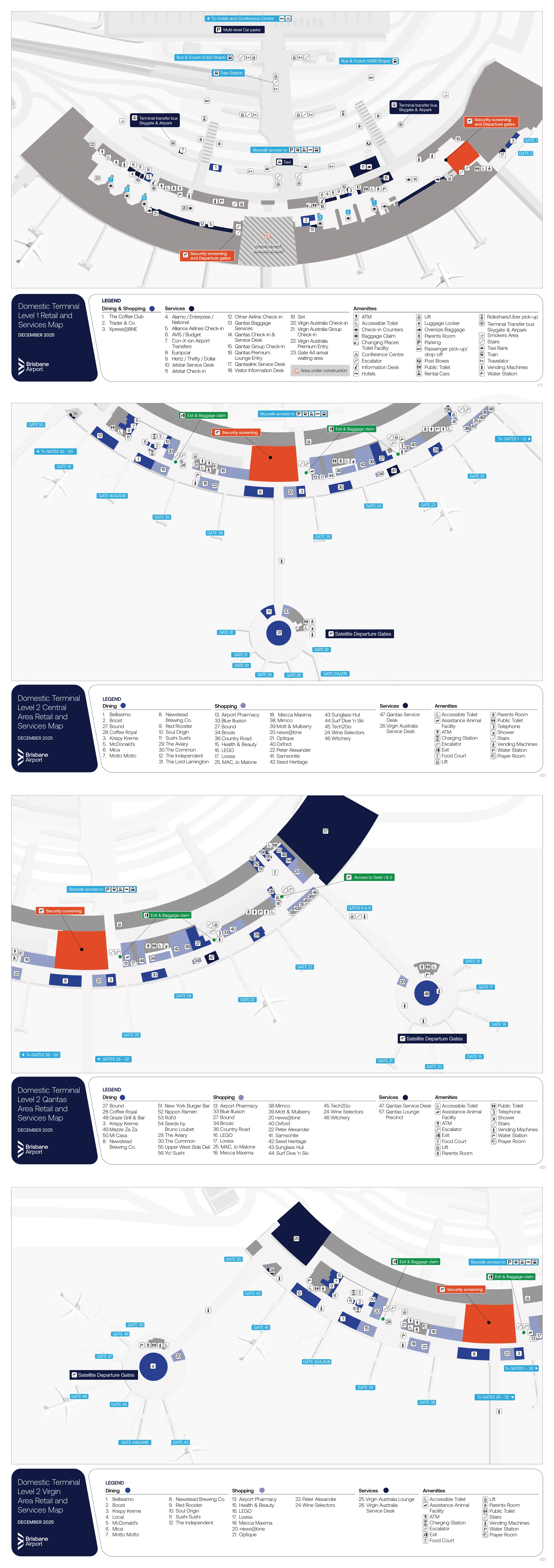
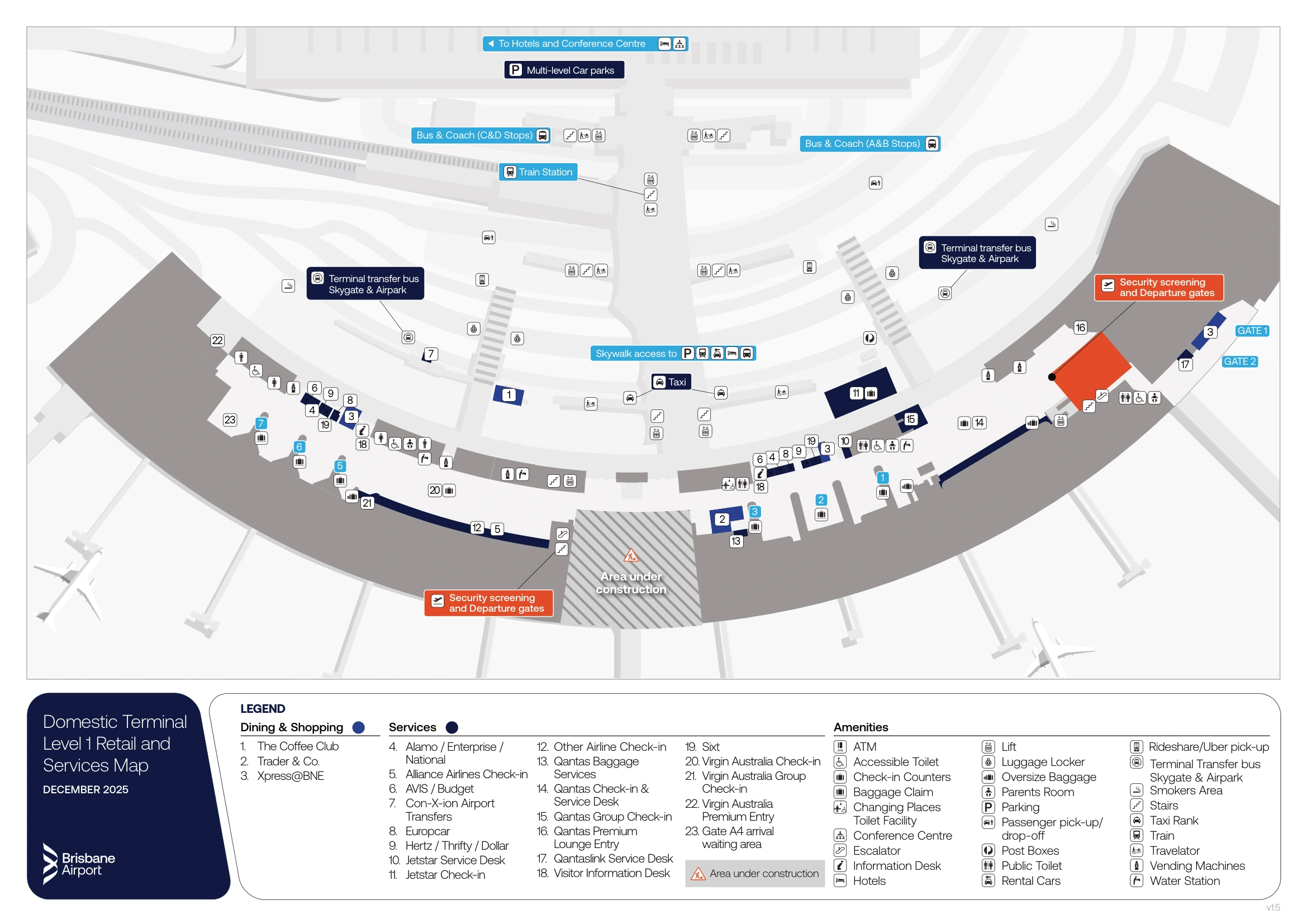
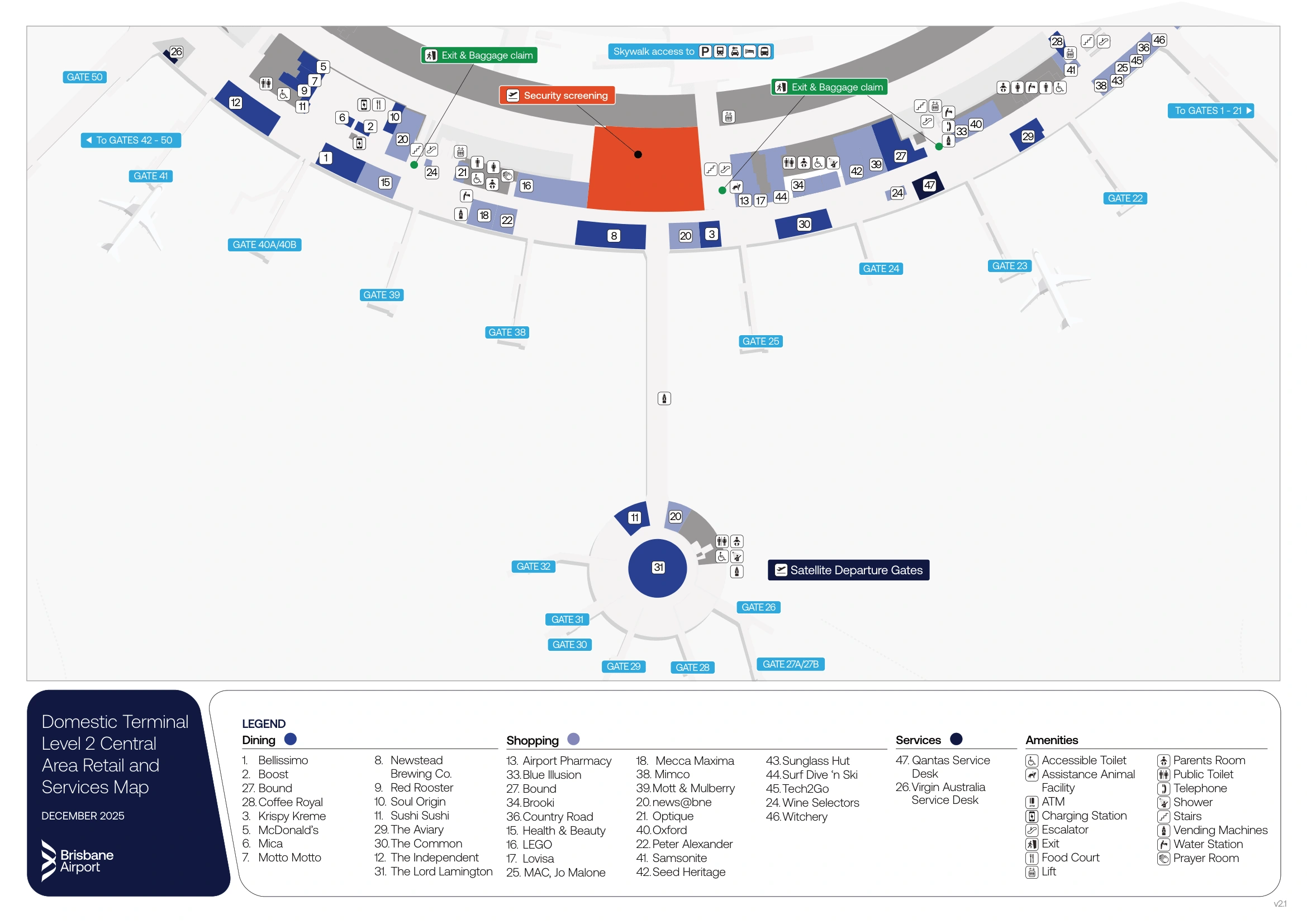
Brisbane International Airport Domestic Terminal Level 1 Map 2025-2026
Brisbane International Airport Domestic Terminal Level 2 Central Map 2025-2026
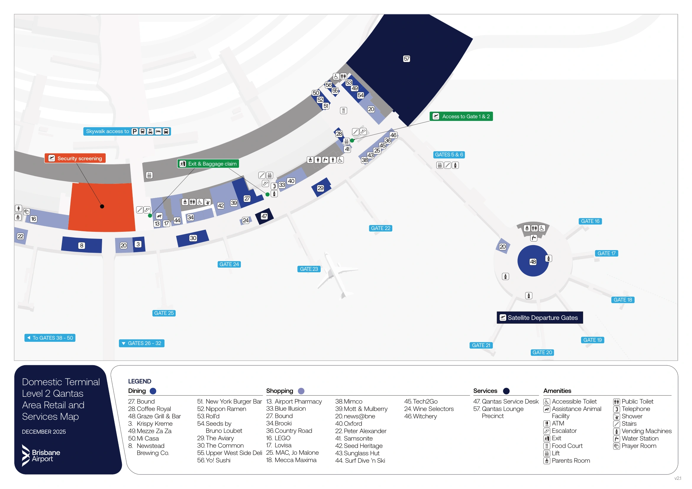
Brisbane International Airport Domestic Terminal Level 2 Qantas Map 2025-2026
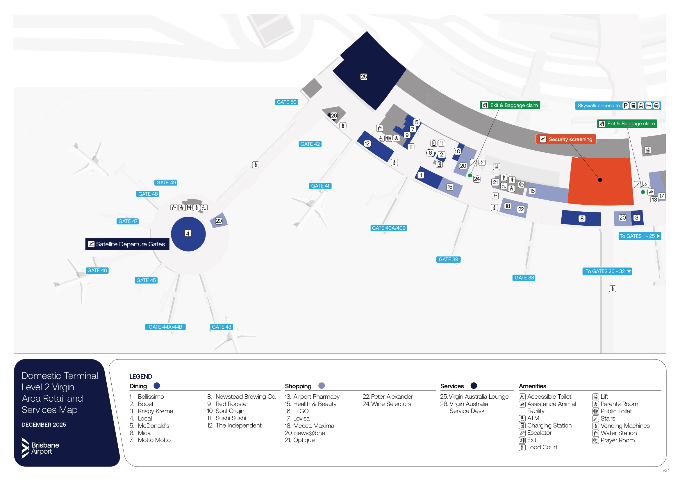
Brisbane International Airport Domestic Terminal Level 2 Virgin Map 2025-2026
2026 Brisbane International Airport Domestic Terminal Map Guide
What is the exact physical start point of the bag drop queue for Qantas at the domestic terminal?
The Qantas bag drop queue starts at the Level 1 self-service kiosk cluster beside Doors 1 and 2, between the terminal glass frontage and the first row of Qantas automated bag drop belts.
Queue formation typically begins at the kiosk “mouth,” then compresses back toward the Doors 1/2 frontage line as volume rises. If you’re facing the kiosks, the belts sit immediately behind/adjacent to the kiosks (toward the interior), while the doors and glass frontage are directly behind you (toward the curb). The practical rule: if you’re not within sight of Doors 1/2, you’re likely not in the Qantas bag drop line.
What is the exact physical start point of the bag drop queue for Virgin Australia at the domestic terminal?
The Virgin Australia bag drop queue starts at the Level 1 self-service kiosk cluster near Doors 5 and 6, aligned to the southern end check-in/bag drop zone.
The queue typically forms at the kiosk cluster first, then stretches back toward the Doors 5/6 frontage line when it surges. The main decision-node trap is assuming the nearest screening is “right there” at the southern end: the practical flow is kiosk cluster → bag drop belts (adjacent, toward the interior) → then transition toward the mezzanine/central screening route. If you’re not close enough to see the Doors 5/6 numbers or the southern Virgin precinct, you’re probably standing in the wrong airline’s bag drop queue.
What is the shortest walking distance (meters) from bag drop to the nearest security entry?
Walking distance is about 50 meters from the Qantas bag drop kiosks (near Doors 1/2) to the nearest security entry at the northern screening point.
This is the tightest bag-drop-to-security link in the terminal, so it’s the fastest “bags down → screening” route when the northern entry is open and stable. The risk is surge volatility: the screening line can suddenly extend out toward the Level 2 corridor near the Qantas Club area, so the physical proximity doesn’t guarantee a quick pass. Use Doors 1/2 as your landmark: bag drop kiosks sit just inside the glass frontage, and the northern security entry is the closest screening option from that node.
Where is the alternate security entry point people use (the “walk to the other end, clear security, walk back airside” tactic), and what corridor does it rejoin after screening?
The alternate security entry is the mezzanine-level Central Screening Area accessed from the Skywalk junction, used when the end-screening line at your current pole is surging.
From the terminal frontage, the access point is at Level 2 where the Skywalk meets the terminal and splits left (toward Qantas/Jetstar) and right (toward Virgin/regional). Clearing screening there drops you into the main airside retail/food precinct, where the circulation corridor runs both directions to gates at the northern and southern ends. Landmarks that confirm you’ve rejoined the correct post-screening corridor include the large open food/retail zone immediately past the lanes (e.g., Bar Roma / Great Northern Bar area).
Where is the exact curbside passenger pickup zone relative to the main arrivals exit doors (which door number/landmark aligns with it)?
Curbside passenger pickup for private vehicles is on the third road from the terminal building (the Passenger Pickup and Drop-off road), aligned outboard of the taxi/T-Bus frontage road.
From the main arrivals exits on Level 1, the closest alignment landmark is the Skywalk support zone: the pickup road sits beyond Macleay Way, so you pass the immediate frontage curb (taxis/T-Bus) and the next road (rideshare area) before reaching private pickup. If you step out of arrivals and are looking at the taxi rank directly in front of you, you are not yet at private pickup—keep moving outward toward the road set behind the central crossings under the Skywalk structure.
Where is the exact rideshare pickup bay/zone (Macleay Way) relative to the terminal exit, and what is the shortest pedestrian route to reach it?
The rideshare pickup zone is on Macleay Way (the second road out), beyond the taxi/T-Bus frontage curb and reached via the central pedestrian crossings under the Skywalk supports.
| Step | Route landmark sequence | Distance |
|---|---|---|
| 1 | Exit Domestic Arrivals (Level 1) at the main doors → face the frontage curb on Stradbroke Way (taxi/T-Bus zone) | — |
| 2 | Walk toward the central pedestrian crossings aligned under the Skywalk structure/support columns | ~20–40 m |
| 3 | Cross the taxi/bus road to the median area, then continue across to Macleay Way | ~20–40 m |
| 4 | Turn to the signed rideshare bays on Macleay Way (Curb 2) | ~10–20 m |
Total walking distance from the arrivals exit doors to Macleay Way rideshare pickup is typically ~60–80 meters.
Where are the short-stay / “free minutes” parking payment machines located relative to the pickup area exit route (i.e., the last chance to pay before barrier)?
The short-stay (ParkShort) payment machines are on Level 2 of the P1 car park near the central lift core, and there are no payment machines at the curbside pickup area.
Cash payment is only possible at those Level 2 P1 machines, so the “last sure chance” to pay with cash is before you drive down to the exit lanes from the car park. Credit card payment can be done either at the Level 2 machines or at the exit barrier itself, but relying on the barrier can create delays if something goes wrong. Use the central lifts/Skywalk transition area as the landmark: if you can see the main lift bank on P1 Level 2, you’re at the payment-machine node; once you’re queued at the barrier, you’ve passed the last easy correction point.
Where is the exact inter-terminal transfer bus (T-Bus) stop outside domestic arrivals, and which curb/zone does it use?
The inter-terminal T-Bus stop is on the front curb on Stradbroke Way, directly outside Domestic Arrivals, using the same immediate frontage curb as the taxi/T-Bus zone.
There are two practical pickup points depending on which end you exit: one outside the northern arrivals doors (Qantas end) and one outside the southern arrivals doors (Virgin end), both marked with bright orange T-Bus signage. The key negative constraint is mode confusion: if you walk out to Macleay Way you’re in rideshare territory and have overshot the T-Bus curb. Use “front curb = taxis + T-Bus” as the rule, and look for the orange signs at the first road nearest the terminal doors.
What is the exact walking distance (meters) from the domestic arrivals exit doors to the T-Bus stop?
Walking distance is about 20–35 meters from the domestic arrivals exit doors to the nearest T-Bus stop on the front curb.
The stop sits on Stradbroke Way at the immediate frontage curb (taxi/T-Bus zone), so the distance is essentially “doors to curb.” If you exit at the northern end (Qantas side), look for the bright orange T-Bus signage outside the northern arrivals doors; if you exit at the southern end (Virgin side), the corresponding orange-signed stop is outside the southern arrivals doors. If you find yourself crossing toward Macleay Way, you’ve gone past the T-Bus curb.
Where does the Skywalk route to the train station begin (exact entry point from the terminal frontage), and which side of the frontage does it sit on?
The Skywalk to the Airtrain station begins at the central part of the terminal frontage on Level 2, at the Skywalk–terminal junction that sits above the central curb crossings.
From the frontage, the entry is not at the immediate arrivals curb: you need to go up to Level 2 (via lifts/travelators) to reach the elevated Skywalk interface. The key landmark is the Skywalk “split” point where you can turn left toward Qantas/Jetstar or right toward Virgin/regional—this junction is the start of the Skywalk corridor that leads out to the train station connection. Practically, it sits in the middle of the building’s frontage rather than at either airline pole.
What is the exact walking distance (meters) from domestic arrivals to the Airtrain station entrance via the Skywalk?
Walking distance is about 150–200 meters from Domestic Arrivals (Level 1) to the Airtrain station entrance via the Skywalk.
The path is “arrivals doors → vertical rise to Level 2 (lift/travelator) → Skywalk entry at the central frontage junction → follow the Skywalk toward the station.” The landmark that confirms you’re on the correct line is the Skywalk–terminal junction above the central curb crossings (the same node where you choose left for Qantas/Jetstar or right for Virgin/regional). If you remain at curb level and keep walking along Stradbroke Way, you’ll miss the elevated Skywalk entry and add unnecessary frontage distance.
Where is the entrance to the new “Skywalk / central screening” security area relative to the domestic car park, and what is the shortest path from parking to trays?
Passengers with carry-on only enter the new Skywalk/central screening area from P1 car park Level 2 via the Skywalk transition, stepping straight into the mezzanine-level security footprint.
From ParkShort in P1, use the central lifts to reach Level 2, then follow the Skywalk transition into the terminal until you reach the Skywalk–terminal junction where the new central screening entrance is integrated. The shortest path is “P1 Level 2 → Skywalk transition → central screening entry → trays,” with no need to descend to Level 1 if you are not checking bags. The negative constraint is absolute: checked bags cannot be dropped on the Skywalk/mezzanine, so any checked-bag passenger must go Level 1 first, then return up to screening.
During peak overflow, where do security queues physically spill (which corridor/level), and which adjacent landmarks indicate you’re in the wrong line?
Security queues spill into Level 2 corridors at both poles: near the Qantas Club entry on the north side, and into the retail precinct near the Virgin Australia Lounge on the south side.
If you’re on Level 2 and the line is running alongside lounge entrances rather than feeding cleanly into visible screening lanes, you’re in an overflow extension and should confirm it’s the correct screening entry for your end of the terminal. North-end overflow that stretches past the Qantas Club area is a cue you’re tied to the northern screening node; south-end overflow that pushes into the retail zone by the Virgin Lounge indicates you’re committed to the southern/central screening flow. A practical “wrong line” signal is seeing the opposite carrier’s lounge precinct: Qantas Club landmarks while heading for Virgin gates, or Virgin Lounge landmarks while aiming for Qantas gates.
Where is the nearest “reset point” after a disruption (clear landmark past screening) that reliably indicates you’re now airside and can route to gates without backtracking?
The nearest reliable reset point is the large open food court and retail area immediately past the screening lanes, where venues like Bar Roma and the Great Northern Bar mark the airside concourse.
Reaching that open precinct is the clear “you’re through” signal: you’re past the security boundary and can route to any gate direction (north to 1–25, south to 38–50) without being forced back landside. If you’re still in tight corridors with queue stanchions, lounge entrances, or visible screening equipment, you have not reached the reset zone yet. Use the first big open retail/food sightline as the orientation lock: from there, gate wayfinding becomes linear rather than decision-node-heavy.
Archive Brisbane International Airport Domestic Terminal Map
Below are all historical map versions for Brisbane International Airport. Each year includes the official map available for that period, presented as both WebP and PDF.
2025-2026 Brisbane International Airport Domestic Terminal Map (Official 2025 Edition)