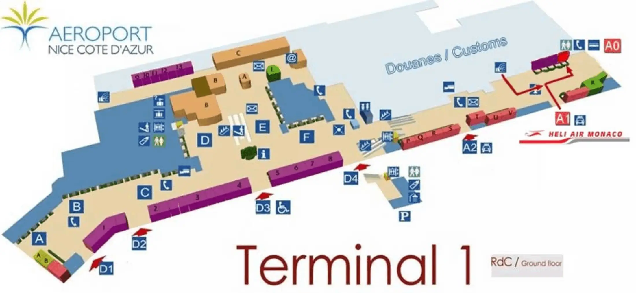
Nice-Côte d’Azur Airport Terminal 1 Map (Most Up-To-Date)
Nice Côte d’Azur Airport Terminal 1 is a compact, older-style terminal with a ground-level landside hall (Arrivals + check-in flow) and a centralized security funnel that feeds a split airside layout (Schengen Zone A vs Non-Schengen Zone B). The fastest “time-to-terminal-action” decisions happen right outside Arrivals: tram vs taxi vs VTC. This page focuses on Terminal 1 inside the Nice airport hub and its immediate ground-transport interfaces (Tram L2/L3, P2 Kiss & Fly, taxi curb).
Map Table
| Zone | Connection | Walk Time |
|---|---|---|
| Arrivals (Exit A0/A1 area) | Tram L2 “Aéroport / Terminal 1”, Taxi rank, P2 Kiss & Fly | 2–5 min |
| Tram L2/L3 platform (T1) | Free Zone to Grand Arénas | 1 stop |
| Grand Arénas hub | Lignes d’Azur standard TVMs, SNCF Nice Saint-Augustin | 8–12 min |
| Central security approach | Gates A/B, Duty Free spine | 3–8 min |
Nice Côte d’Azur Airport Terminal 1 Map Strategy
- Treat the tram as a compliance puzzle, not a ride: T1 ↔ Grand Arénas is the Free Zone; the irreversible boundary is Grand Arénas—once the tram departs it citybound, you need a valid, validated ticket or fine risk spikes.
- Skip the “airport ticket” trap at the platform: use the free 1-stop ride (or ~550 m walk, ~8–12 min with luggage) to Grand Arénas for standard €1.70 products and clearer machine menus.
- Validate only where it actually works: on-board yellow validators near doors (“Je monte, je valide”); if you’re leaving the Free Zone, validate immediately after boarding—waiting for a platform validator wastes time and increases miss/fine risk.
- Sequence Non-Schengen airside decisions: security first, then passport control, then gate—duty-free and lounge time only after you’re past the border pinch point (a wrong “shop-first” choice can cost 20+ minutes when queues spike).
2026 Nice-Côte d’Azur Airport Terminal 1 Map + Printable PDF
Terminal 1 remains fully operational in 2026, with passenger flow shaped by its centralized security layout and the Schengen/Non-Schengen split beyond it. The biggest “map-critical” changes aren’t new corridors—they’re queue behavior and border processing (especially for Non-Schengen departures) plus the Tram L2/L3 Free Zone rules around Grand Arénas that affect what you buy and when you must validate.
2026 Nice-Côte d’Azur Airport Terminal 1 Map Guide
What is the exact walking distance from Terminal 1 Arrivals exit doors to the Tram L2 “Airport / Terminal 1” platform entry point?
Walking distance is about 150 meters from Terminal 1 Arrivals (Exit Gate A0 area) to the Tram L2 “Aéroport / Terminal 1” platform access.
The practical route is straight-line simple but speed-variable: exit Terminal 1 Arrivals at the A0 doors, follow the tram pictograms toward the curbside crossing, use the marked pedestrian crosswalk over the internal airport roadway, then stay on the signed pedestrian path that runs parallel to the tram tracks until you reach the open platform entry. With luggage, this typically takes 2–3 minutes, and the only real delay risk is the signalized crosswalk cycle.
What is the exact walking route (turn-by-turn landmarks) from Terminal 1 to the Grand Arenas tram stop using only signed pedestrian paths?
The signed pedestrian route is the outdoor walkway that runs parallel to the tram tracks from Terminal 1 Arrivals (Exit Gate A0) to Grand Arénas, totaling about 550 meters.
Exit Terminal 1 via Arrivals Exit Gate A0, then follow the tram/“Grand Arénas” directional signage toward the curbside crossings. Use the marked pedestrian crosswalks to get past the internal terminal roadway, then stay on the dedicated paved path that aligns beside the tram alignment. Continue past the bus-station area and the access points for the P2 car park entry, keeping the tram tracks consistently on your left/right as the fixed navigation reference. Follow signs into the Grand Arénas multimodal hub entrance area, where the tram stop and the station interfaces cluster. With luggage, plan 8–12 minutes depending on crosswalk cycles and crowding.
Where are the physical ticket vending machines inside/adjacent to Terminal 1 that sell the standard €1.70 fare, and how far are they from the main tram access point?
No ticket vending machines at the Terminal 1 tram platform reliably sell the standard €1.70 “Solo” fare; the airport-platform machines are configured to push the higher-priced “Aéro” products.
For the standard €1.70 fare, the nearest reliable physical TVMs are at Grand Arénas (the next stop and the Free Zone boundary). From the Terminal 1 tram platform access, the distance to the Grand Arénas TVMs is about 1 tram stop or roughly a 550-meter walk (about 8–12 minutes with luggage). The clean, low-risk sequence is: board at Terminal 1 (Free Zone), ride to Grand Arénas, buy “Solo” (€1.70) or “La Carte” at the standard station machines, then re-board toward the city.
Where is the first validator point a rider can legally validate a ticket when boarding from Terminal 1 (exact location of validator(s) on platform or inside the tram)?
The first workable validator is inside the tram, not on the Terminal 1 platform.
Terminal 1’s Tram L2/L3 platform access is open (no gates/turnstiles), and the validation hardware is the yellow validator boxes mounted on vertical stanchions just inside the tram doors. Board through any door, then validate immediately at the nearest yellow box before you move down the aisle with luggage. This matters most when you’re leaving the Free Zone: if you board at Terminal 1 intending to go past Grand Arénas, the “validate every time you board” rule applies as soon as you’re traveling beyond the free segment, and inspectors commonly appear right after Grand Arénas.
What is the exact boundary point (stop and platform edge) where the “free airport segment” ends and ticket validation becomes required (map it as a single named stop boundary)?
The boundary is Grand Arénas station—the free segment ends when the tram departs Grand Arénas toward Parc Phoenix (city direction) or Paul Montel/CADAM (north direction).
The “Zone de Gratuité” is limited to three stops: Aéroport Terminal 2, Aéroport Terminal 1, and Grand Arénas. Travel between those three stations is free, and you do not need a ticket for that segment. The irreversible decision point is the Grand Arénas platform: if you remain onboard after Grand Arénas and the tram doors close to continue onward, every rider must already have a ticket and must have validated it onboard at the yellow validator near the doors. This is the fine-risk transition zone.
Where is Arrivals passport control physically located in Terminal 1, and what is the shortest walking route from arrival gates to that hall?
Arrivals passport control is in the inbound Arrivals processing hall immediately before baggage reclaim for non-Schengen arrivals in Terminal 1.
Follow the green “Arrivals” flow from the gate, staying in the sterile arrivals corridor until it funnels into the immigration hall with passport booths/e-gates. Keep moving with the main passenger stream—don’t follow signs for exits or ground transport. After you clear passport control, you spill directly into baggage reclaim, then continue to Customs and the public Arrivals exit doors (Exit Gate A0 area). From most arrival gates, the walk to the passport control hall is typically a few minutes on a single signed route with no alternative corridors worth taking.
Where is the non-Schengen departures passport control point in Terminal 1, relative to the main security exit (exact path and distance)?
Non-Schengen departures passport control is directly after the main security exit at the entrance to Zone B, positioned at the end of the Duty Free circulation spine.
From the security exit, walk straight into the Duty Free area and follow overhead signs for “Gates B” / “Non-Schengen.” Stay on the main retail corridor (do not peel off into seating or café pockets), and continue until the corridor constricts into the roped immigration queue for the passport booths/e-gates. The walking distance from the security exit to the passport control entry is about 120 meters (roughly 2 minutes at a normal pace), and it’s an irreversible timing point: once you commit to shopping, the border queue can still be between you and your gate.
Where is the centralized security checkpoint entrance in Terminal 1 (exact level + approach corridor), and what is the walking distance from the main check-in hall to that entrance?
The centralized security checkpoint entrance is at the end of the main landside check-in hall on the ground level, reached by following overhead “Departures / Gates A & B” signage into the single security hall.
From the middle of the check-in desk zones, walk toward the terminal’s central departure funnel (the direction the crowd naturally streams), keeping the check-in rows behind you and the retail/Duty Free direction ahead. The standard lanes sit in the middle of the hall; the Fast Track (“Nice Access”) entry is on the far left side of the same security frontage. The walk from central check-in to the security entry is about 80 meters (roughly 1–2 minutes), with time loss driven by picking the wrong side and having to cross back through the queue frontage.
What is the shortest walking path from Terminal 1 security exit to the furthest common international gate cluster in Terminal 1 (distance in meters)?
Walking to the furthest common gate areas from the Terminal 1 security exit is about 350–450 meters.
After security, follow the main airside circulation path past Duty Free, then keep following overhead gate signage to the end of the relevant pier. For Schengen flights, this is typically the far end of Pier A (often cited around the A14-area); for non-Schengen flights, include the extra segment through passport control to reach the far B-gate end. At a brisk pace, 350–450 meters is usually 5–8 minutes, but the real variability is the border queue for Zone B—distance stays similar, dwell time does not.
Where is the closest staffed help/information point to the Terminal 1 tram access (exact location), and what is the walking distance from the platform?
The closest staffed help point is the Terminal 1 Arrivals-facing ground transport/terminal assistance area inside the landside Arrivals hall near Exit Gate A0/A1, not on the tram platform itself.
From the Tram L2 “Aéroport / Terminal 1” platform access, walk back along the signed pedestrian path toward Terminal 1 and re-enter the Arrivals frontage by the main exit doors (A0/A1 zone). The distance is typically about 150–200 meters depending on where you step off the platform, and the reliable landmark is the Arrivals exit doors and the ground-transport signage cluster (Taxi/VTC/Bus). If you need human confirmation before committing to the Free Zone boundary logic, do it before you cross the curb lanes toward the tram.
Where is the official taxi rank pickup point for Terminal 1, and what is the exact walking distance from the primary Arrivals exit?
The official taxi rank is immediately outside Terminal 1 Arrivals at Entrance A1 on the curbside taxi lane.
Exit Terminal 1 Arrivals through the main doors (A0/A1 area) and follow the “Taxi” signs to the managed queue directly outside Entrance A1, where staff feed passengers to the next car. From the primary Arrivals exit doors, the walking distance is essentially curbside-adjacent—about 30–60 meters depending on which door you use and where the queue head is positioned. This is the highest-certainty pickup point in bad weather because it avoids the crosswalk and car-park walk required for VTC.
Where is the rideshare / VTC pickup zone for Terminal 1, and what is the exact walking route from Arrivals that avoids crossing restricted curb lanes?
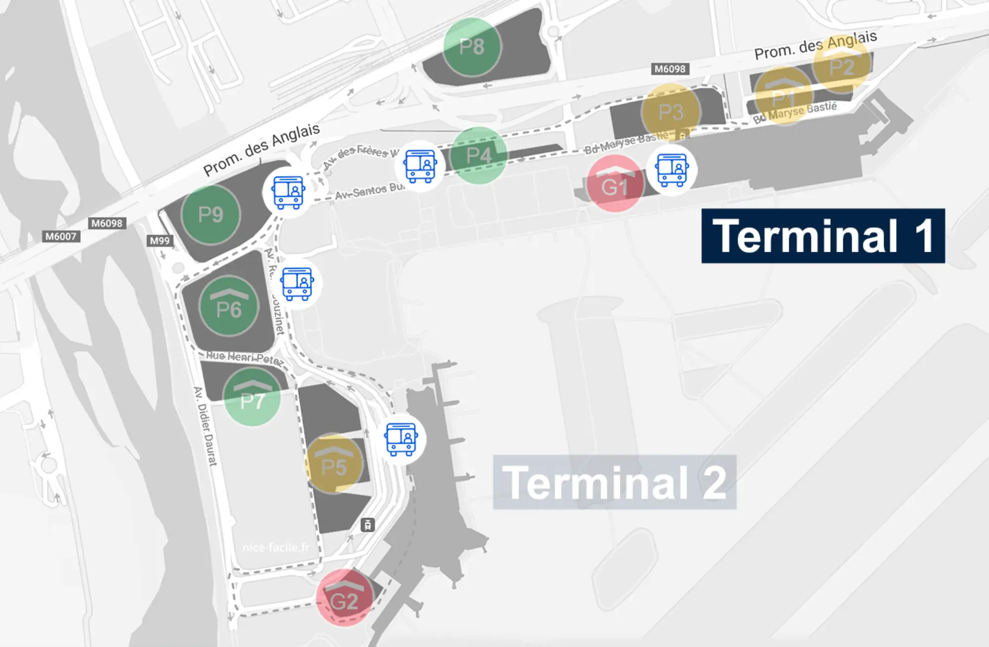
The rideshare/VTC pickup zone is inside Car Park P2 “Kiss & Fly” (Dépose-minute) directly opposite Terminal 1 Arrivals.
From Terminal 1 Arrivals, exit at the A0/A1 doors and follow signs for P2 / Parking rather than Taxi. Use the marked pedestrian crosswalk to cross the arrivals curb lanes (do not attempt to walk along the taxi-only lane edge), then continue straight into the P2 car park entrance. Once inside the structure, follow internal wayfinding for “Kiss & Fly” lanes and stop only at the signed pickup curb. The critical timing rule is operational: order the car only after you clear Customs and are walking out of Arrivals, because the P2 free window is short and drivers often wait to enter until you confirm you’re physically at the Kiss & Fly curb.
Where are the nearest restrooms after security in Terminal 1, and what is the distance from the security exit to the closest one?
The nearest restrooms are immediately after security in the first airside circulation zone, typically adjacent to the first major Duty Free/retail corridor junction.
After you exit the centralized security checkpoint, look for the first toilet block signage positioned along the main airside spine before you commit deep into the pier walk. In Terminal 1, toilets commonly cluster with amenity nodes (toilets + sometimes a water point) near the main circulation rather than inside the far gate rooms. Distance from the security exit to the closest toilets is typically about 30–80 meters (around 1 minute), depending on which side you exit security onto and whether the nearest block is just left or right of the Duty Free entry.
Where is the nearest water source (fountain/refill) airside in Terminal 1, and what is the walking distance from the main security exit?
The nearest water source is usually the low-profile drinking fountain positioned near the first airside toilet block just beyond the security exit.
From the main security exit, stay on the primary airside circulation spine and scan the first restroom area for a small wall-mounted fountain (often less visible than bottle-fill stations in North American airports). In Terminal 1, fountains are commonly colocated with toilets in transit zones rather than placed in open seating areas, and maintenance can vary (pressure/temperature). Distance from the security exit to the closest likely fountain location is typically about 30–120 meters (1–2 minutes). If the fountain is out of service, the fastest fallback is to ask an airside café/bar to refill a bottle with tap water.
Archive Nice-Côte d’Azur Airport Terminal 1 Map
Below are all historical map versions for Nice-Côte d’Azur Airport. Each year includes the official map available for that period, presented as both WebP and PDF.
2011 Nice-Côte d’Azur Airport Terminal 1 Map