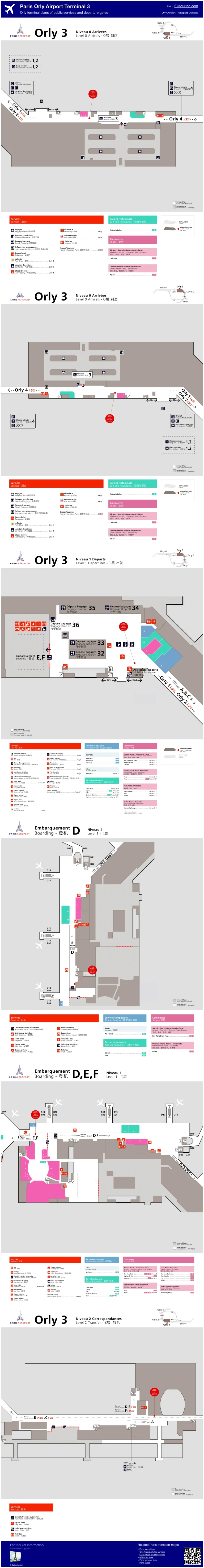
Kuala Lumpur International Airport Terminal 2 Map (Most Up-To-Date)
Kuala Lumpur International Airport Terminal 2 is a long, two-part terminal: an airside Satellite (P/Q piers) connected by a straight Skybridge to the Main Terminal Building, then a landside spill-out into the Gateway@klia2 mall that hides transport one level down. As part of the main Kuala Lumpur airport grounds, the critical orientation is vertical: arrivals processing and Express Rail Link ticket gates sit on Level 2, while most ground transport lives on Level 1.
Map Table
| Zone | Key Connectors | Primary Function | Critical Level |
|---|---|---|---|
| Satellite (P/Q) | Skybridge | International gates | L2–L3 |
| Skybridge Nexus | 300 m bridge | Satellite ↔ MTB | L3 |
| Main Terminal Building | Descent core | Immigration, reclaim | L2 |
| Gateway@klia2 | Vertical cores | Landside routing to rail/bus/Grab | L2 → L1 |
Kuala Lumpur International Airport Terminal 2 Map Strategy
- Treat Kuala Lumpur International Airport Terminal 2 as a vertical puzzle: Level 2 is arrivals + Express Rail Link ticket gates, Level 1 is buses/taxis/Grab; commit to the correct down-transition early.
- Default to the Express Rail Link train for Kuala Lumpur International Airport Terminal 1 transfers when time-critical; the shuttle-bus path bakes in bay-walking and schedule penalties.
- Protect your buffer for Immigration: the Skybridge descent corridor into the Level 2 Immigration intake is where velocity collapses into queues.
- Navigate by decision nodes, not “exits”: Doors 1–4 (Level 2) and “Car Park” (Level 1) are common wrong-turn traps that strand you away from transport.
2026 Kuala Lumpur International Airport Terminal 2 Map + Printable PDF
Operational reality at 2026 Kuala Lumpur International Airport Terminal 2 is still “distance + decision nodes”: long gate-to-processing walks, level changes that punish wrong turns, and a landside mall interface that can misroute you into private pickup or parking. A printable map matters most for map-verifiable routing to the Express Rail Link ticket gates, the Level 1 transportation hub, and the Kuala Lumpur International Airport Terminal 2 to Kuala Lumpur International Airport Terminal 1 transfer choice points.
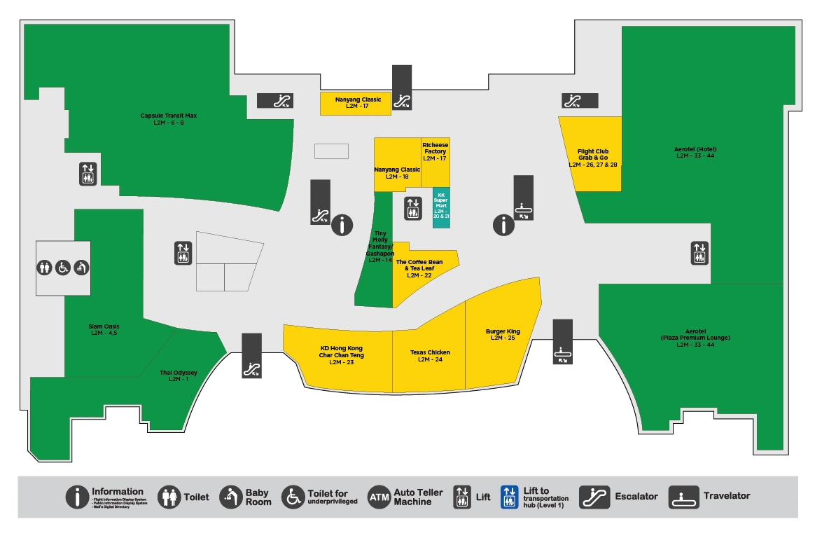
Kuala Lumpur International Airport Terminal 2 Level 1 Map 2025
Kuala Lumpur International Airport Terminal 2 Level 2 Arrivals and Checkpoint Map 2025
Kuala Lumpur International Airport Terminal 2 Level 2 Mezzanine Map 2025
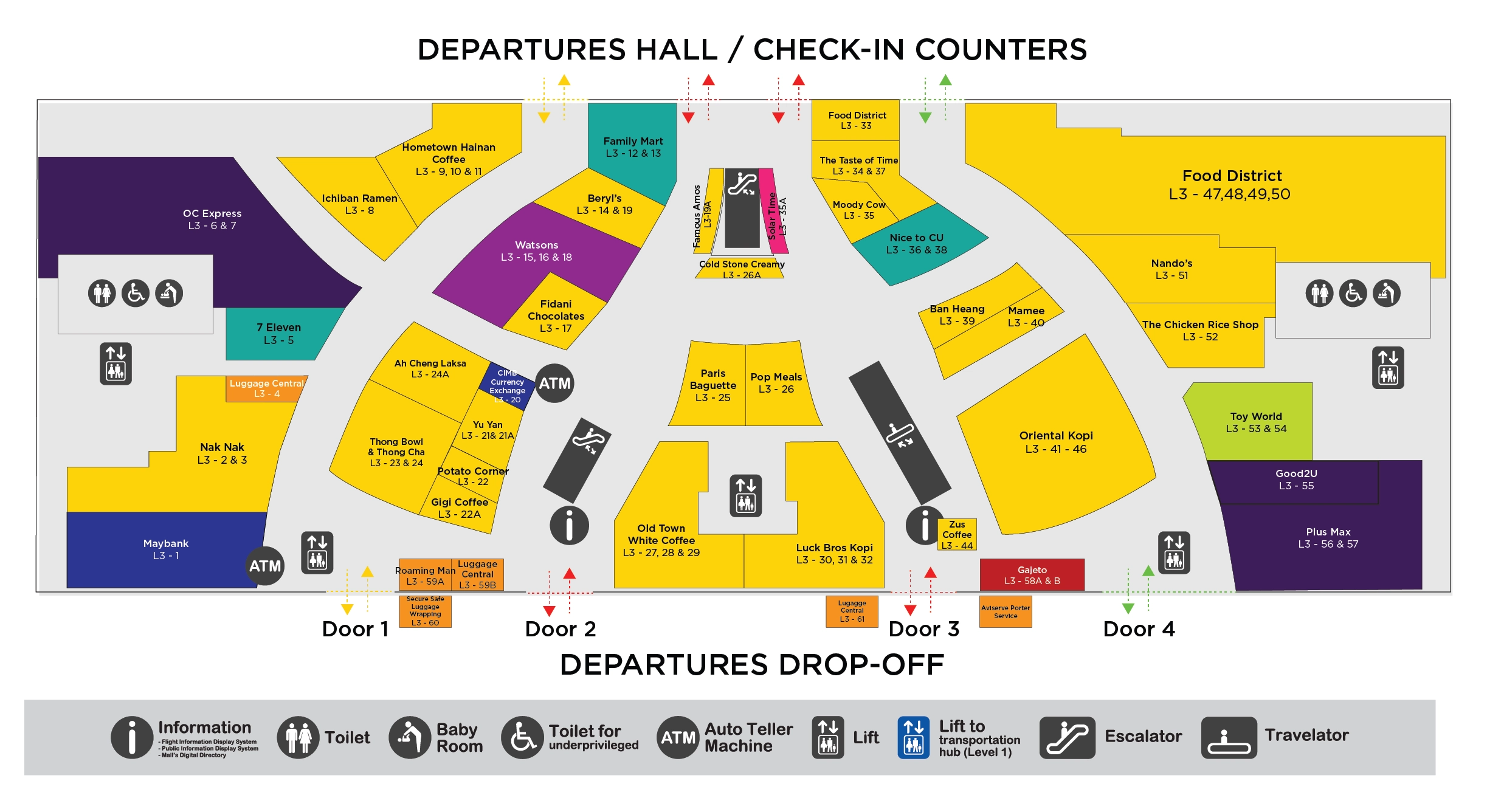
Kuala Lumpur International Airport Terminal 2 Level 3 Departures Map 2025
2026 Kuala Lumpur International Airport Terminal 2 Map Guide
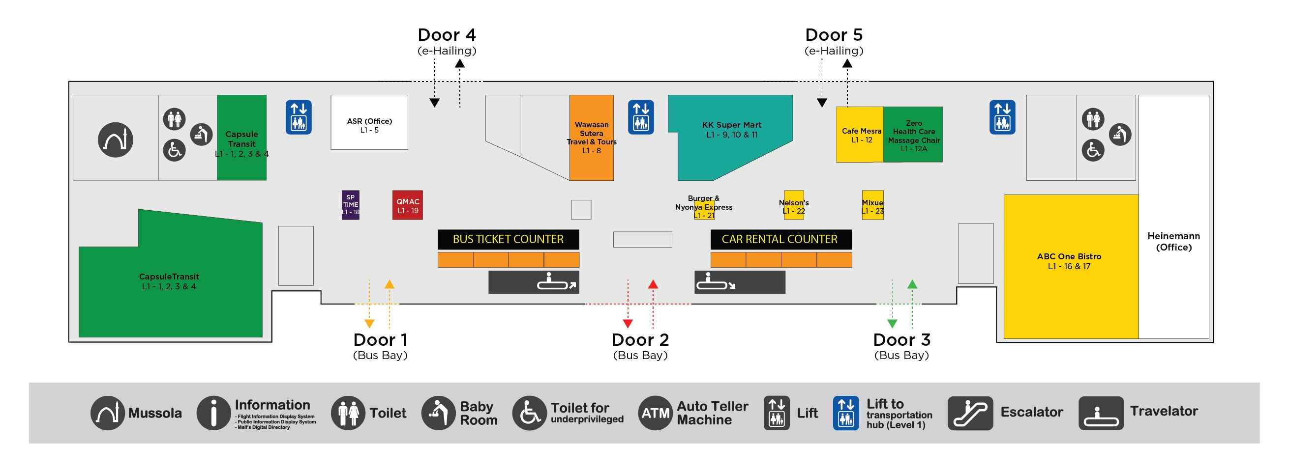
What is the shortest mapped walking route from KLIA2 International Arrivals to the KLIA Ekspres/Transit station entrance (including the exact level and first decision point)?
The Express Rail Link ticket gates on Level 2 are the shortest-access station entrance from Kuala Lumpur International Airport Terminal 2 International Arrivals, with the platform reached by descending to Level 1 after the gates. The first decision point is the mall-entry split at Gateway@klia2, where turning into retail wings slows you and can divert you toward private pickup doors.
Exit International Customs into Gateway@klia2 on Level 2, then keep straight on the main concourse toward the central atrium with OldTown White Coffee and Family Mart as the near-right landmarks. Continue forward to the Express Rail Link ticket counters and fare gates in the center of the Level 2 mall spine, then enter through the gates and take the escalator down to the Level 1 train platform.
What is the exact walking distance (meters) from KLIA2 International Arrivals exit to the Terminal 1 shuttle-bus stop (landside), measured by the fastest path?
Approximately 550 meters is the fastest mapped walking distance from Kuala Lumpur International Airport Terminal 2 International Arrivals exit to the Terminal 1 shuttle-bus stop at Bay A10 on Level 1. The dealbreaker is that this walk only gets you to the bay; missing the bus typically adds a 10–15 minute schedule penalty before the drive even starts.
From the International Arrivals exit on Level 2 (by OldTown White Coffee and Family Mart), walk straight to the central travelator/escalator well signed for Transportation Hub and descend to Level 1. At the bottom, turn right toward the bus-bay corridor, pass the ticket-counter cluster, and continue along the platform frontage to Bay A10 near the far end of the bays.
Where exactly is the KLIA2-to-Terminal-1 train ticketing/gate line relative to the main arrivals hall (left/right orientation and level), as shown on the terminal map?
The Kuala Lumpur International Airport Terminal 2 to Terminal 1 train ticketing and fare-gate line is on Level 2, straight ahead into Gateway@klia2 from the International Arrivals exit, slightly center-right on the main mall axis. The dealbreaker is that going down to Level 1 too early puts you into the bus/taxi zone and forces a backtrack for the rail gates.
From the main arrivals flow exiting Customs on Level 2, keep your body orientation facing into the mall atrium (not toward Doors 1–4). The Express Rail Link counters and gates sit as a central “spine” feature that visually bisects the concourse, with OldTown White Coffee and Family Mart as near-right landmarks on the approach. Once you see the gate line, the platform access is immediately after the gates via escalators down to Level 1.
What is the mapped “minimum viable” path from KLIA2 train arrival (Terminal 1 side) to Terminal 1 departures check-in zone, using the fewest decision points?
The fewest-decision path is the main lift bank from the Express Rail Link arrival level straight up to the departures check-in deck, avoiding the cascading escalators and intermediate floors. The dealbreaker is that following “Departures” via escalator banks increases decision nodes and makes it easy to pop out on the wrong level before check-in.
Exit the train at the Kuala Lumpur International Airport Terminal 1 Express Rail Link station on Level 1 and walk to the station concourse by the fare gates. Locate the main glass lift bank within the station–terminal interface (the large central lift core near the station exit), select Level 5, and ride directly up. Step out on Level 5 and walk straight into the departures check-in zone toward the check-in islands.
From a typical KLIA2 international arrival gate pier, what is the longest possible walking distance to Immigration (worst-case gate-to-Immigration path on the map)?
About 1.2–1.4 kilometers is the longest mapped walk to Immigration from the farthest international gates, typically Gate Q21 or Gate P21 in the Satellite P/Q piers. The dealbreaker is that this distance is a hard constraint before queues start, so a “tight” connection can fail purely on walking time.
The worst-case path runs the full pier length from the gate to the Satellite hub, then forces a vertical move up to reach the Skybridge entry, followed by the full 300-meter Skybridge crossing to the Main Terminal Building. After the bridge, the flow descends back toward Level 2 and funnels through the connector corridor into the Immigration hall intake. The pinch happens right after the Skybridge descent, where Pier P/Q traffic merges with other international flows just before the Immigration entrance.
Which baggage claim carousel zone is physically closest to the arrivals corridor (shortest walk from Immigration exit), based on the KLIA2 map layout?
The higher-numbered international baggage carousels are the closest zone to the Immigration exit corridor, typically the group around carousels 7–10. The dealbreaker is that walking to the wrong end of the reclaim hall costs time twice—once to get there and again to return toward Customs.
After you clear Immigration, follow the arrivals corridor into the baggage reclaim hall and orient yourself using the central flow line that feeds into the middle/right side of reclaim. The international belts cluster nearer the Customs side of the hall, so the closest pickup tends to be the first visible bank of higher-numbered belts near the main reclaim entrance path, rather than the lower-numbered domestic belts that sit farther down the hall behind glass-partitioned separation.
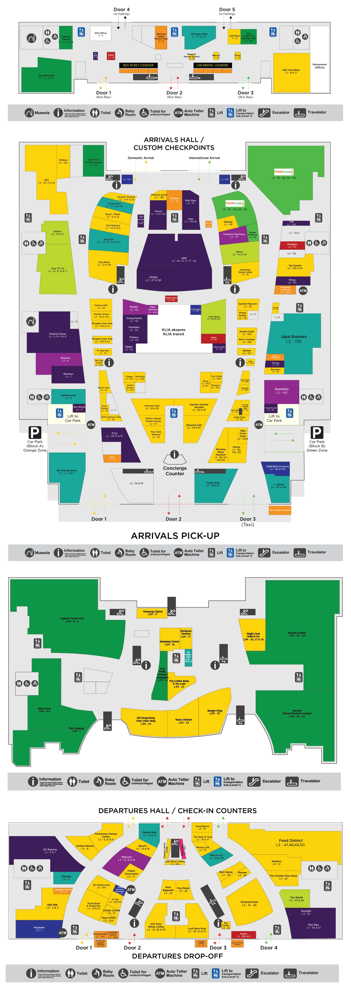
Where is the primary Grab/e-hailing pickup point for KLIA2 on the ground transport map (exact bay/zone label), and which terminal exit is closest to it?
Door 5 on Level 1 is the primary Grab/e-hailing pickup point for Kuala Lumpur International Airport Terminal 2, and Door 5 is also the closest terminal exit to that pickup zone. The dealbreaker is that waiting at Level 2 doors (private pickup) can strand you, because e-hailing vehicles are staged and enforced at Level 1.
From the International Arrivals exit into Gateway@klia2 on Level 2, aim for the lift cores near the mall-side landmarks (the lift lobby by Coffee Bean / the lift cluster referenced as C & D) and go directly down to Level 1. Exit the lift into the transportation hub frontage and follow signs to Door 5, where the Grab lounge/waiting area is typically positioned immediately inside the Door 5 vestibule before the curb interface.
What is the shortest covered-walkway route from KLIA2 departures area to the Tune Hotel connection (map-confirmed covered segments only)?
The Level 1M mezzanine link bridge is the shortest fully covered route from Kuala Lumpur International Airport Terminal 2 departures to the Tune Hotel connection. The dealbreaker is that Level 1 curbside attempts can expose you to rain and unsafe crossings, and Level 2–3 routes do not provide the same continuous covered connection.
From Departures on Level 3, walk into Gateway@klia2 and navigate toward the central mall spine using the OldTown White Coffee and Family Mart area as your Level 2 reference landmark. Locate the escalator bank specifically signed for Level 1M (Mezzanine), descend to Level 1M, then turn right to the covered link bridge entrance. Stay on the enclosed bridge all the way to the Tune Hotel lobby connection.
Where are the “wrong-turn traps” between KLIA2 Arrivals and Ground Transport (the points where signage branches to parking vs buses vs train), as shown on the map?
Doors 1–4 on Level 2, the “Car Park” exits on Level 1, and the Satellite “Transfer” split are the main wrong-turn traps that repeatedly strand people away from trains, buses, and e-hailing. The dealbreaker is that each trap looks like an “exit,” but leads to private pickup, parking blocks, or an airside transfer zone that does not connect to landside transport.
- Level 2 mall exits (Doors 1–4) off the Gateway@klia2 atrium, which dump you into private vehicle pickup instead of the transportation hub.
- Level 1 “Car Park A / Car Park B” doorways near the transport concourse, which pull you into parking structures instead of the internal bus-bay corridor.
- Level 2 “Transfer” signage at the Satellite hub, which can divert self-transfer passengers into an airside security area when they actually need Arrivals for Immigration, baggage, and landside routing.
What is the exact map distance from KLIA2 international check-in counters to the furthest departure gates (longest check-in-to-gate walk)?
Approximately 1.3 kilometers is the longest mapped walking distance from Kuala Lumpur International Airport Terminal 2 international check-in on Level 3 to the furthest departure gates in the Satellite P/Q piers, such as Gate Q21. The dealbreaker is that this distance stacks with Immigration and security friction, so “gate time” needs a larger buffer than the check-in hall suggests.
The worst-case path runs from the check-in islands through outbound processing to the Skybridge access, then across the full 300-meter Skybridge into the Satellite building, followed by the full length of the pier to the extreme gate. The distance penalty is highest when your gate is at the tip of Pier Q or Pier P, because the final pier segment adds a long, linear walk after you’ve already committed to the bridge crossing.
Which single corridor/connector carries the majority of foot traffic from gates to Immigration (the “chokepoint hallway”) and where does it pinch on the map?
The Level 2 connector corridor immediately after the Skybridge descent is the chokepoint hallway, and it pinches at the merge point where Skybridge arrivals join the other international stream right before the Immigration hall entrance doors. The dealbreaker is that this is where fast walkers hit “velocity zero” and queue logic becomes chaotic.
After crossing from the Satellite via the Skybridge on Level 3, arriving passengers funnel down to Level 2 through the main descent core into a relatively narrow connector run. That corridor then compresses multiple inbound flows—Satellite Pier P/Q traffic plus the Pier L stream—into the single intake into Immigration. On the map, the pinch is located just past the transfer-desk area and immediately before the glass-door threshold into the Immigration hall queue field.
What is the shortest mapped route from KLIA2 domestic arrivals to the inter-terminal transfer point (train/shuttle decision area), without exiting into the wrong landside zone?
The mall-center spine on Level 2 is the shortest mapped route from Kuala Lumpur International Airport Terminal 2 domestic arrivals to the inter-terminal transfer decision area, keeping you aligned with the Express Rail Link gates and the central descent to the Level 1 transport hub. The dealbreaker is that an immediate left turn off domestic arrivals can leak you toward the Tune Hotel direction and away from the train/bus decision node.
Exit domestic arrivals into Gateway@klia2 on Level 2 and orient toward the mall atrium rather than the side corridors. Turn right promptly to rejoin the central concourse, then continue toward the Express Rail Link ticket gates (train option) and the central travelator/escalator well signed for Transportation Hub (shuttle-bus option). Keep your movement on the main Level 2 axis until you can visually confirm the ERL gate line or the signed descent core.
On the KLIA2 map, where is the nearest re-pack / seating area to Immigration exit that can function as a “recovery point” before the long walk to transport?
The nearest practical recovery point is the Gateway@klia2 mall atrium seating immediately outside Customs on Level 2, near the Meeting Point pillar and the Family Mart / OldTown White Coffee cluster. The dealbreaker is that there is essentially no usable seating or repack space in the post-Immigration corridor before Customs, so you must clear Customs to stop.
After you exit Immigration, continue through the corridor into Customs and clear the sliding-door exit into the mall on Level 2. The first usable open area with benches and enough space to reorganize bags is right in the atrium zone just beyond that exit, where meeting-point signage and high-traffic food-and-convenience storefronts sit close to the main flow line. This spot also keeps you aligned for the next decision: straight ahead for rail gates or down to Level 1 for transport.