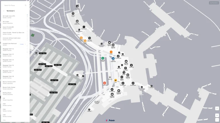
John Wayne Airport Terminal B Map (Most Up-To-Date)
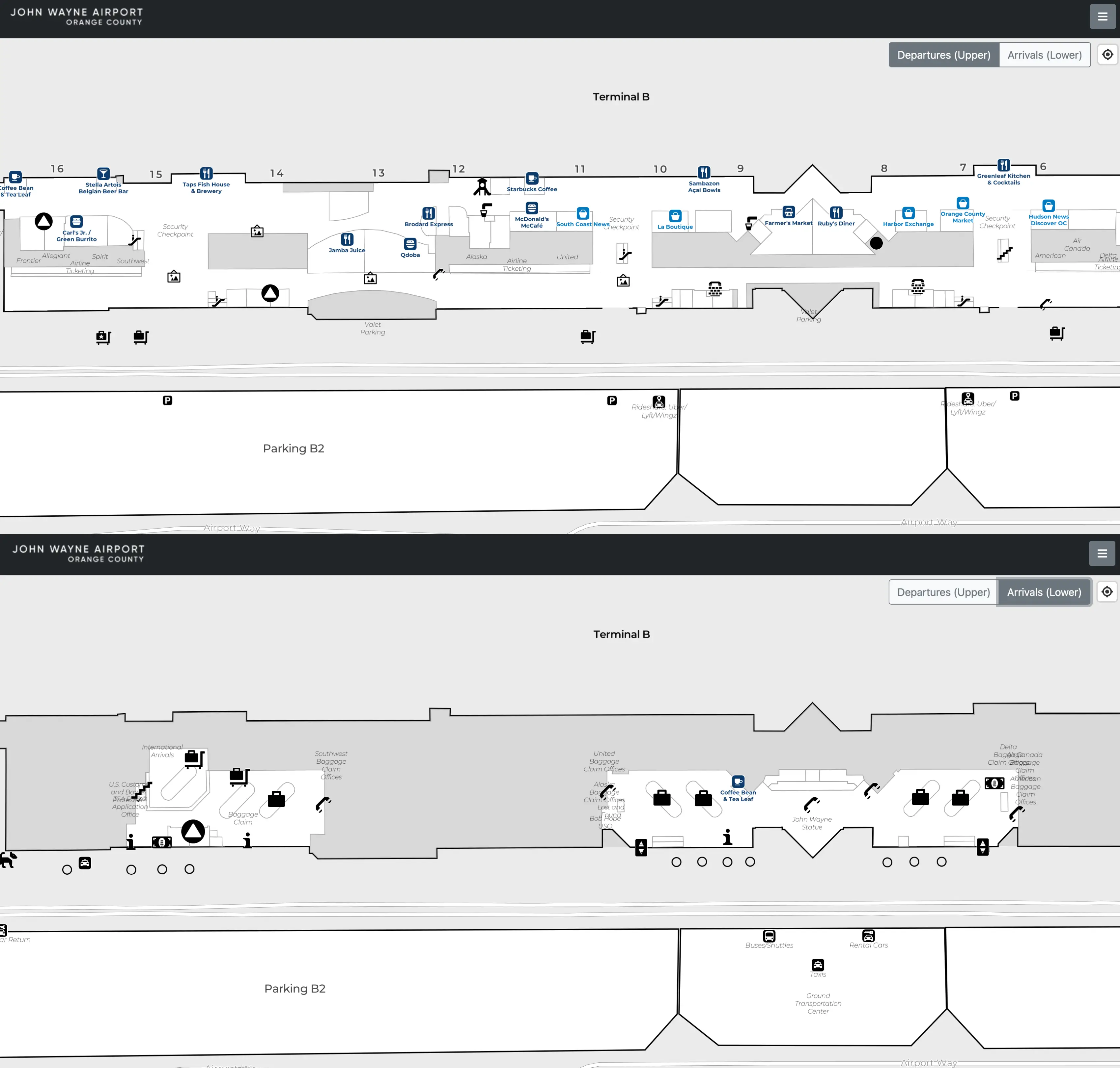
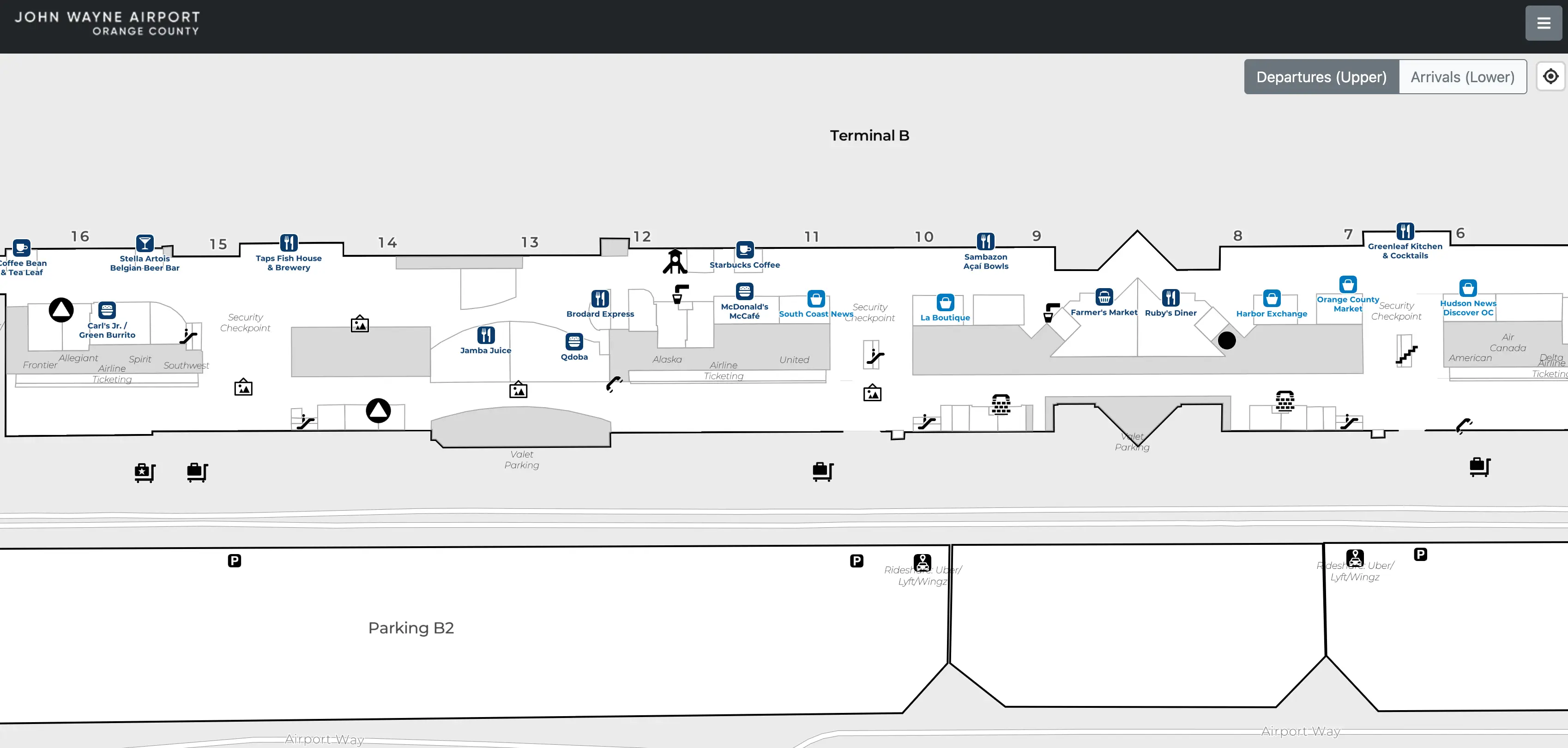
Terminal B sits in the middle of the Thomas F. Riley Terminal as a straight, linear concourse bridging Terminals A (north) and C (south) within Orange County’s airport hub. The footprint is compact but stretched end-to-end: landside ticketing and Checkpoint B are centered, while gates run south–north along one main airside corridor (Gates 9–15). Most time loss comes from choosing the wrong curb/door, wrong checkpoint, or wrong parking bridge.
Map Table
| Zone | Connection | Walk Time |
|---|---|---|
| Gates 9–15 | linear airside corridor | Gate 11: 1.5–2 min from Checkpoint B |
| Checkpoint B | central departures hall | curb-to-checkpoint: < 1 min |
| Ticketing (United/Alaska) | doors under United/Alaska canopy | counters-to-checkpoint: < 1 min |
| Parking Structure B2 | Level 3 pedestrian bridge | bridge-to-checkpoint: 2–3 min |
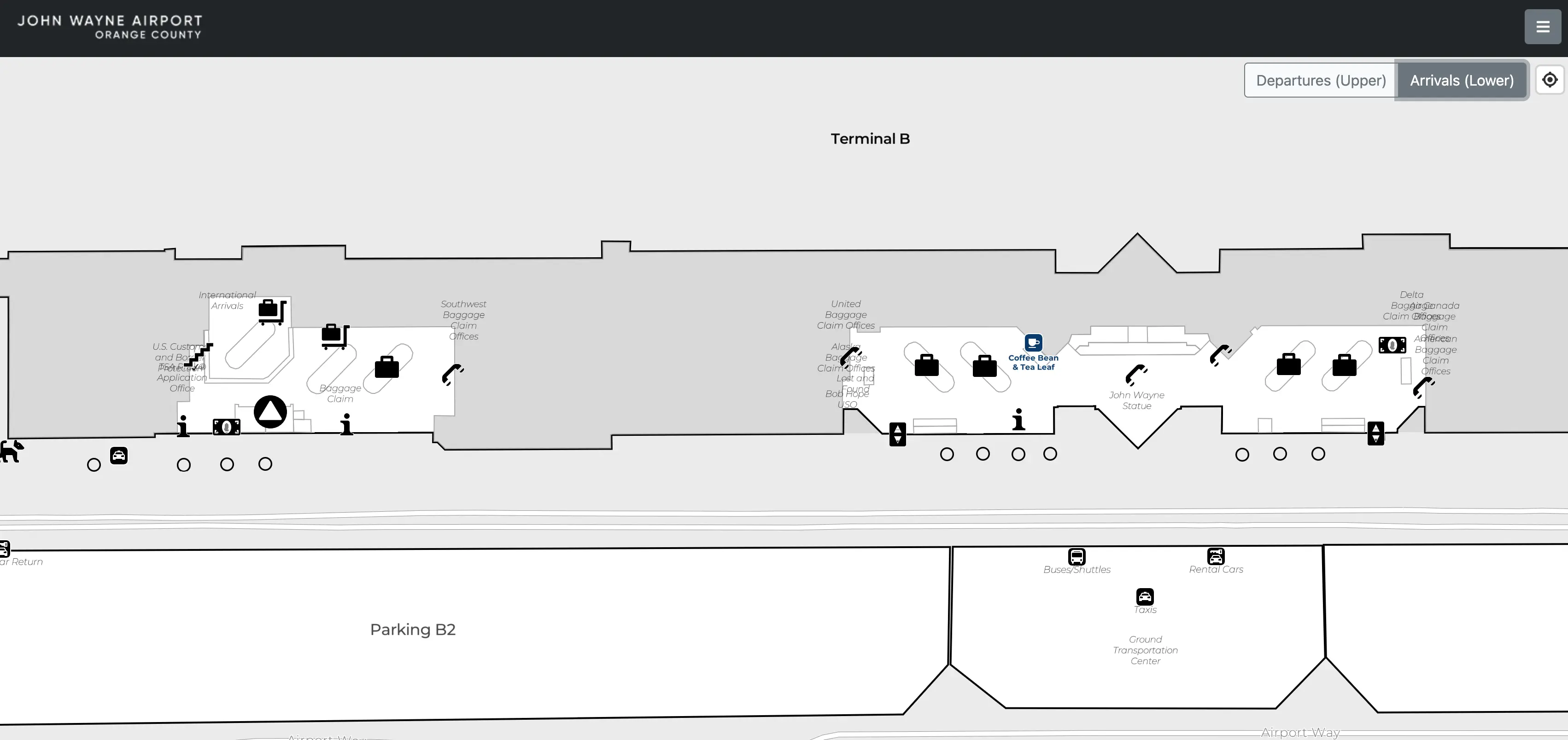
| Baggage Claim (B) | Carousels 3–4, Arrivals level | baggage-to-rideshare: 5–7 min |
| Terminal A connector | Ruby’s Diner / Gate 9 node | A exit to B corridor: ~300 ft |
| Terminal C connector | Gates 16–15 transition | direct northbound link |
John Wayne Airport Terminal B Map Strategy
- Use Checkpoint B only when it’s flowing; if the line spills into the lobby, pivot landside to Checkpoint A or Checkpoint C (short walk) and still rejoin the same airside corridor.
- Treat curb choice as the first “gate”: Departures level under United/Alaska canopy, then the closest automatic doors (commonly Door 2/3) to avoid backtracking through ticketing.
- For parking, target Parking Structure B2 and think “Level 3 first”: park near the elevator core, get to the Level 3 bridge, then enter directly into the departures hall near Terminal B ticketing.
- Minimize detours by chaining tasks: bag-check at the United/Alaska counters flanking Checkpoint B, then walk straight to screening; for arrivals rideshare, exit by Carousel 4, cross to Parking Structure B2, and go straight up to Level 3.
2026 John Wayne Airport Terminal B Map + Printable PDF
Terminal B remains the central “keystone” sector (Gates 9–15) in the contiguous A–B–C layout, so all checkpoints still feed the same secure corridor without re-clearing. The operational gotchas are unchanged: rideshare pickup remains on the parking structure top deck, Parking Structure B2’s bridge is the fastest self-park approach to Terminal B, and curb congestion makes door selection more important than raw distance.
John Wayne Airport Terminal B Arrivals Map 2025
John Wayne Airport Terminal B Departures Map 2025
2026 John Wayne Airport Terminal B Map Guide
What is the exact walking time from Terminal B Security Checkpoint to Gate 11 (minutes, using the shortest airside route)?
Walking takes about 1.5–2 minutes from the Terminal B Security Checkpoint exit to Gate 11 on the shortest airside path.
Exit screening into the recomposure area, then angle slightly right toward the central concessions core opposite the checkpoint exit. Gate 11 sits just beyond that node on the tarmac-facing side of the main corridor, essentially a line-of-sight walk from the end of the belt. During a busy deplaning wave at Gates 9–10, cross-traffic can add roughly 30 seconds, but Gate 11 remains one of the closest gates to Checkpoint B.
What is the exact walking distance from Terminal B Security Checkpoint to Gate 14 (feet/meters, shortest airside path)?
Walking distance is approximately 450 feet (137 meters) from the Terminal B Security Checkpoint exit to Gate 14 on the shortest airside path.
From the checkpoint exit near the Gate 10/11 core, make a right turn to head southbound along the main concourse. Continue straight past Gates 11, 12, and 13, keeping to the main corridor as you approach the Terminal B–Terminal C boundary zone. Gate 14 sits near the distal end of the Terminal B sector, so retail islands and passenger clustering near the concessions spine can slightly increase stepped distance even when the route is direct.
Where is the Arrivals curb drop-off point that minimizes walking distance to Terminal B ticketing (identify the closest door/entry on the map)?
Dropping off on Arrivals for Terminal B ticketing adds a vertical penalty, so the closest Arrivals option is the curb area by the John Wayne statue with the doors that feed the central elevator/escalator bank up to Departures.
Stop on the Arrivals (lower) roadway in the central sector aligned with Terminal B, using the bronze John Wayne statue as the curbside landmark. Enter the terminal through the nearest doors and move directly to the elevator/escalator core adjacent to the Terminal B baggage claim area (near the Carousel 4 zone), then ride up to Departures to emerge into the middle of the Terminal B ticketing hall. Elevator waits are the main delay compared with a Departures drop-off.
What is the shortest curb-to-checkpoint route from the Departures drop-off to Terminal B Security Checkpoint (identify the exact door/escalator path)?
The shortest route is Departures curb under the United/Alaska canopy → the nearest sliding doors (commonly Door 2/3) → straight through kiosks to Checkpoint B.
On the upper roadway, stay in the Terminal B frontage until the overhead signs switch from American/Delta to United and Alaska. Exit the vehicle immediately under the United/Alaska signage and enter the automatic doors directly beneath that canopy (often numbered Door 2 or Door 3 along the departures facade). Inside, walk straight across the open ticketing hall, passing the self-service kiosks; the security queue entrance is centered on the rear wall, with United counters on the right side and Alaska counters on the left side as you approach.
What is the shortest walking route between Terminal A Security exit and the Terminal B gate corridor (identify the exact connector segment on the airside map)?
The connector is the Ruby’s Diner / Gate 9 transition corridor, and it does not require re-clearing security.
From the Terminal A security exit, turn right and walk airside past Gate 7 and Gate 8 toward the dining node anchored by Ruby’s Diner. Stay on the main level concourse (no stairs needed) as you pass the mezzanine access point for the Admirals Club and United Club in the same zone. Immediately beyond that landmark, the gate numbering flips to Gate 9, marking the start of the Terminal B gate corridor. This is the primary, level arterial link from A into B.
What is the shortest walking route between Terminal C Security exit and the Terminal B gate corridor (identify the exact connector segment on the airside map)?
The connector is the northbound concourse transition from Gate 16 to Gate 15, and it stays entirely airside without re-clearing security.
From the Terminal C security exit, turn left to head north toward Terminal B and continue past Gate 16 along the main corridor. Keep following the straight concourse as the architecture shifts from the newer Terminal C profile into the Terminal B sector; this transition zone is the functional connector on the airside map. The first Terminal B gate encountered from this direction is Gate 15, which marks the entry into the Terminal B gate corridor.
Where is the closest Terminal B baggage claim exit to the primary rideshare pickup path (identify the specific door/elevator/escalator shown on the map)?
The closest exit is the doors adjacent to Baggage Carousel 4, which line up with the fastest path to the crosswalk toward Parking Structure B2 and its elevator core to Level 3.
Collect bags at the Terminal B carousel cluster (typically Carousel 3 or 4), then bias toward the Carousel 4 side of the hall and use the nearest glass exit doors there. Outside, do not wait at the Arrivals curb; instead, follow the marked pedestrian crossing directly across to Parking Structure B2. Once inside the structure, go straight to the elevator lobby and ride up to Level 3, where the ride-app pickup zone is signed on the top deck.
What is the walking time from Terminal B baggage claim to the main Ground Transportation / rideshare pickup area (minutes, shortest signed route)?
Walking time is about 5–7 minutes from Terminal B baggage claim to the rideshare pickup area using the shortest signed route.
Exit near the Carousel 4 doors, then cross the roadway at the marked crosswalk toward Parking Structure B2 (this street crossing is the first time variable). Enter the structure and go to the elevator core; elevator wait time is the biggest swing factor during arrival banks when luggage crowds fill cabs. Ride up to Level 3 and walk a short distance on the top deck to the signed ride-app pickup zone near the elevator exit. Travelers with light bags can save time by taking stairs if the elevator line is long.
Which parking structure entrance produces the shortest walking distance to Terminal B ticketing (identify the entrance/bridge/door on the map)?
Parking Structure B2 produces the shortest walk, using the Level 3 pedestrian bridge into the Departures hall nearest Terminal B ticketing.
Enter Parking Structure B2 from the airport roadway system, then prioritize getting to Level 3, because that is where the pedestrian bridge originates. Park near the elevator/stair core so you can reach the bridge quickly, then follow the covered bridge across the roadway into the terminal facade doors on the Departures level. This bridge drops you into the central Terminal B ticketing zone aligned with the United and Alaska counters, avoiding the longer lateral walks required from Structure A2 or Structure C.
What is the walking time from the closest parking structure pedestrian exit to Terminal B Security Checkpoint (minutes, shortest route)?
Walking time is about 2–3 minutes from the Parking Structure B2 pedestrian bridge exit to the Terminal B Security Checkpoint on the shortest route.
Cross the covered pedestrian bridge from Parking Structure B2 (about a one-minute walk), enter the Departures-level doors at the terminal end of the bridge, then continue straight across the Terminal B ticketing hall toward the rear wall where Checkpoint B is centered. The indoor segment from doors to the checkpoint queue is short (roughly 100 feet), but lobby crowding can slow the last stretch. This timing assumes you are already on Parking Structure B2 Level 3; if you park on a lower level and need the elevator first, add several minutes for the elevator cycle.
Where exactly is the bag-check counter zone for Terminal B’s primary carriers located relative to the Terminal B checkpoint (identify the map position and the direct walking path)?
Bag-check counters sit immediately beside Checkpoint B, with United to the right and Alaska to the left when facing the checkpoint from the curb.
Enter the Terminal B departures doors under United/Alaska signage and walk straight toward the rear wall where the checkpoint queue forms. The United counter line runs along the right side of that central hall, while Alaska’s counter line runs along the left side, flanking the checkpoint entry so the lateral move from counter end to TSA document check is minimal. After tagging and dropping bags, take the shortest path by cutting directly toward the centered checkpoint opening rather than backtracking toward the curbside doors.
What is the walking time from the Terminal B ticketing counters to Terminal B Security Checkpoint (minutes, shortest indoor path)?
Walking takes less than 1 minute from the Terminal B ticketing counters to the Terminal B Security Checkpoint on the shortest indoor path.
The ticketing hall and Checkpoint B share the same open room, so there is no separating corridor. From either the United counter zone on the right side or the Alaska counter zone on the left side (when facing the rear wall), the direct path is a short lateral move into the centered checkpoint queue entry. The distance is roughly 30–60 feet depending on your exact counter position, though early-morning queue spillover can block the straight line and force a slow merge into the security line.