San Francisco Bay Oakland International Airport Terminal 2 Map (Most Up-To-Date)
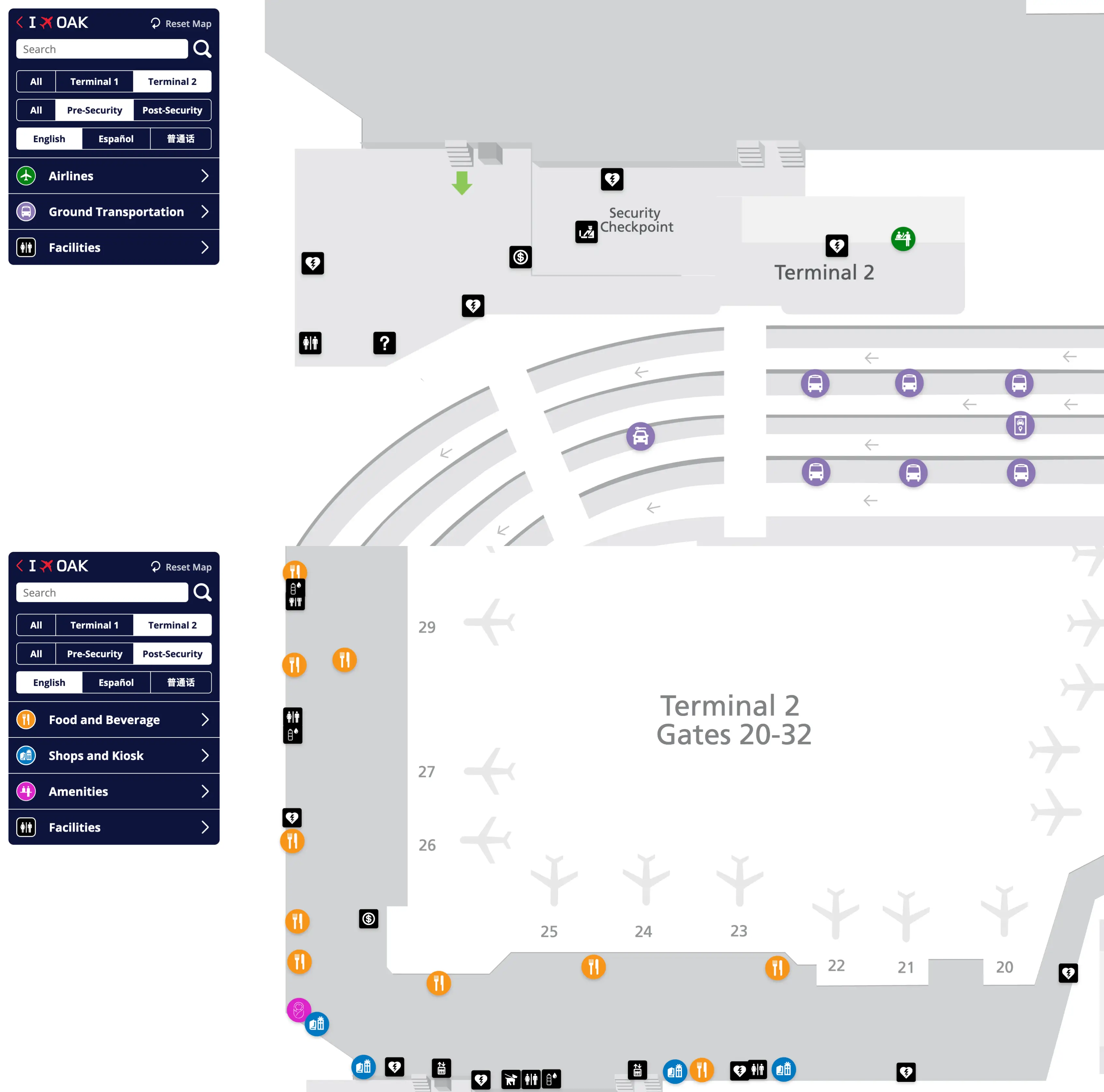
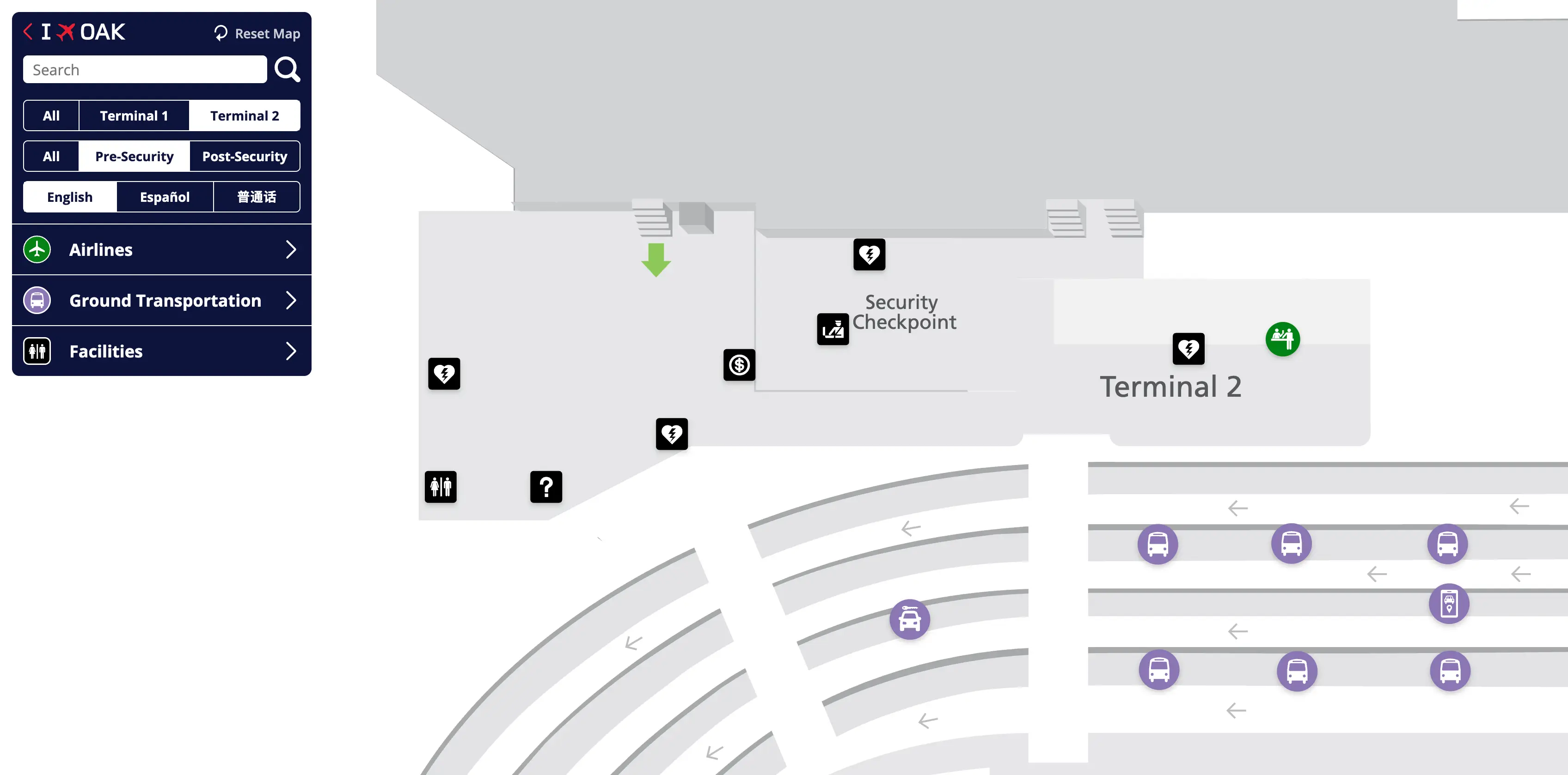
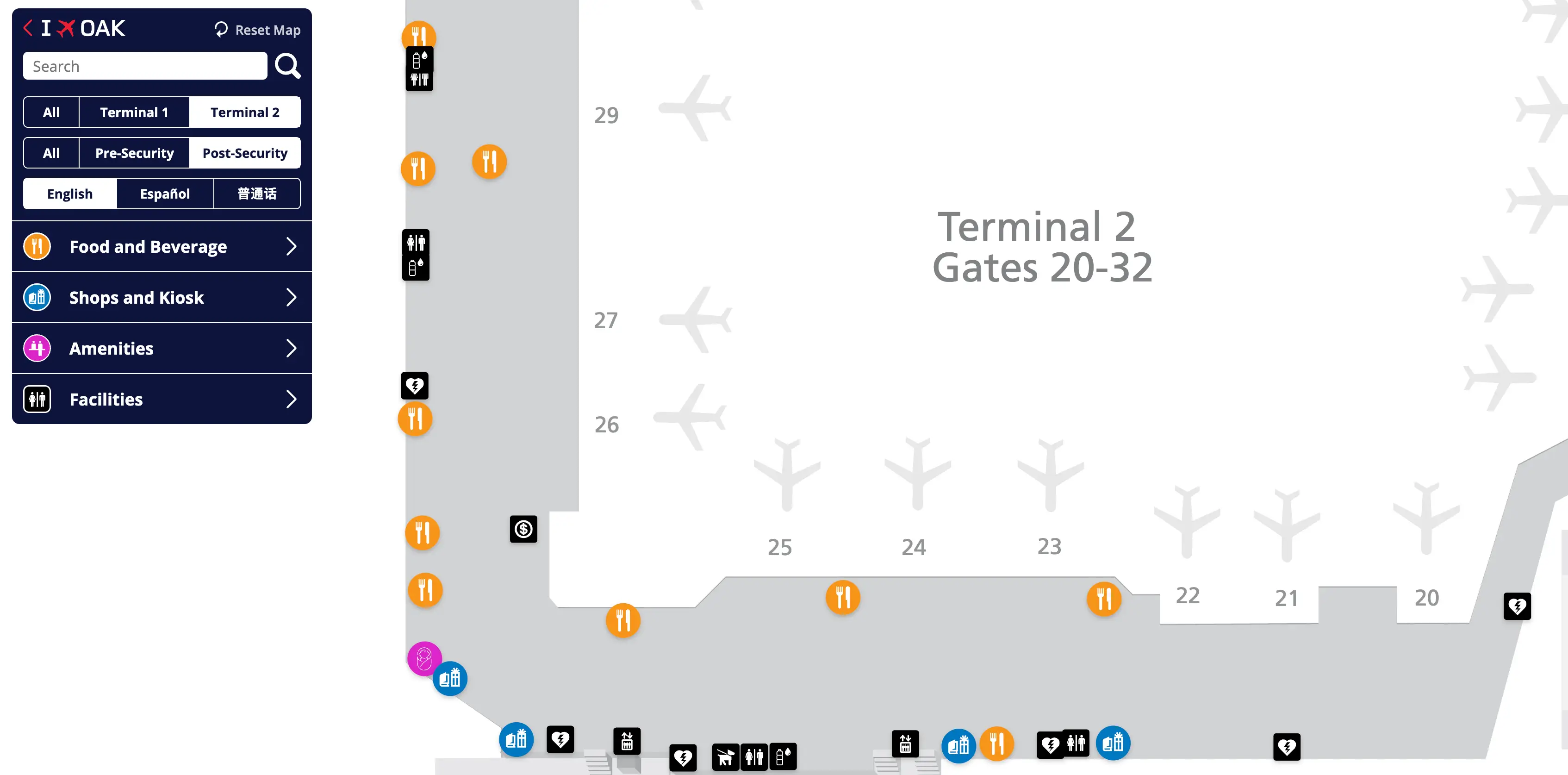
Oakland International Airport Terminal 2 is a linear, single-concourse Southwest terminal (Gates 20–32) with a ground-level checkpoint that can bottleneck fast, especially during banked departures. The space “feels small,” but passenger surges concentrate at the front door. Inside the East Bay airport complex, the key orientation is west-to-east along the pier: the Terminal 1–Terminal 2 airside connector feeds in near Gate 20, while higher gate numbers pull you deeper down the concourse.
Map Table
| Zone | Connection | Walk Time |
|---|---|---|
| T2 ticketing + curb doors | Landside sidewalk to Terminal 1 | 3–4 min |
| T2 security vestibule | Gate 20 concourse neck | 1–3 min |
| Gate 20–22 cluster | T1–T2 airside connector | 2–4 min |
| Gates 26–32 stretch | Mid-concourse amenities | 4–8 min |
Oakland International Airport Terminal 2 Map Strategy
- Treat Terminal 2 security as a choke point; if the line is outside or wrapping at the doors, pivot immediately to Terminal 1 screening and commit to the airside connector.
- Anchor navigation on the connector endpoints: Terminal 1 side near Gate 4 signage for “Gates 20–32,” Terminal 2 side emerging at the Gate 20 entry node.
- Build a fixed “walk buffer” into your plan (connector + concourse) so you’re never hostage to slow screening throughput at Terminal 2.
- Use Gate 20–22 as the first stabilization zone after entering Terminal 2 (decision point for restrooms, food, then straight-line walk to higher-numbered gates).
2026 San Francisco Bay Oakland International Airport Terminal 2 Map + Printable PDF
Checkpoint conditions at Terminal 2 stay volatile in 2026 because the lobby is shallow and the queue can spill past the doors during Southwest departure banks. The most reliable “print-and-follow” tactic is planning both entry options: Terminal 2 screening when it’s moving, and the real workaround—clear Terminal 1 security, then walk airside through the Gate 4 ↔ Gate 20 connector into the Terminal 2 concourse.
San Francisco Bay Oakland International Airport Terminal 2 Pre Security Map 2025
San Francisco Bay Oakland International Airport Terminal 2 Post Security Map 2025
2026 San Francisco Bay Oakland International Airport Terminal 2 Map Guide
What is the exact walking distance (in feet/meters) from Terminal 1 security exit to the airside corridor entry that leads toward Terminal 2 gates?
The walk is approximately 350 feet (106 meters) from the Terminal 1 security exit to the airside connector corridor entry toward Terminal 2. That distance is short because the checkpoint empties into Terminal 1’s central rotunda, and the connector is an immediate adjacency near the Gate 4 pier rather than a deep concourse trek.
| Segment | Map anchor | Distance |
|---|---|---|
| Security egress → main rotunda | top of checkpoint exit into the central holdroom | short, within the 350 ft total |
| Rotunda → connector entry | follow “Gates 20–32 / Terminal 2” toward Gate 4 | balance of the 350 ft (106 m) |
Where is the airside connector path between Terminal 1 and Terminal 2 on the map (the specific corridor/turn points, not “it’s connected”)?
The airside connector is the enclosed sterile corridor that runs from Terminal 1 near Gate 4 and delivers you into Terminal 2 at the start of the concourse by Gate 20. It functions like a bridge between the two buildings: you stay post-security, walk straight through the glass-walled passageway parallel to the ramp, and emerge already inside Terminal 2’s Gate 20–22 “neck” area.
- Start in Terminal 1’s secure concourse and orient toward the Gate 4 pier using signs for “Terminal 2” or “Gates 20–32.”
- Enter the connector corridor on the concourse wall near Gate 4 (this is the committed turn away from Gates 1–3 and into the bridge).
- Walk the enclosed corridor that spans the inter-terminal gap (no re-screening, no outdoor segment).
- Exit into Terminal 2 immediately adjacent to Gate 20, then continue straight down the pier for Gates 21–32.
What is the walking time (minutes) from Terminal 1 security to typical Terminal 2 Southwest gate clusters, using map-measured distance?
Walking takes about 4–6 minutes to reach Terminal 2’s entry point at Gate 20, 7–9 minutes to the mid-concourse cluster around Gate 26, and 10–12 minutes to the far end near Gate 32. The timing is driven by three legs: a short move from Terminal 1 security to the Gate 4 connector, the connector corridor itself, then the straight-line Terminal 2 pier walk from Gate 20 to your gate number.
| Destination cluster | Airside anchor | Walk time |
|---|---|---|
| Gate 20 entry | connector exits into T2 at Gate 20 | 4–6 min |
| Gates ~26 mid-concourse | main amenity node area | 7–9 min |
| Gates ~32 far end | end-of-pier terminus | 10–12 min |
From Southwest check-in in Terminal 2, what is the shortest mapped route to Terminal 1 security (the workaround path), and what is its distance?
The shortest route is the landside sidewalk transfer from Terminal 2’s ticketing doors to Terminal 1’s ticketing doors, then up to the Terminal 1 checkpoint escalators, totaling about 500–650 feet (150–200 meters). The path is simple because the terminals are adjacent buildings: you stay outside security, follow the facade, and enter Terminal 1 directly rather than trying to cut through any interior sterile area.
- Exit Terminal 2 ticketing to the curbside sidewalk.
- Turn left (west) and follow the building frontage across the inter-terminal gap.
- Enter Terminal 1 ticketing doors and head to the central escalators/elevators up to the security mezzanine.
- Join Terminal 1 security and proceed post-screening toward Gate 4 signage for “Gates 20–32.”
On the map, where are the Terminal 2 security queue overflow zones located (areas where lines can extend outside/into corridors) relative to doors and entrances?
The overflow zones are the curbside sidewalk stretches directly in front of Terminal 2’s main ticketing and baggage-claim door banks (commonly Doors 2–4), where the interior stanchion area backflows through the sliding doors. The key geometry is linear: the queue propagates backward from the checkpoint vestibule toward the curb, then can wrap along the Terminal 2 facade toward Terminal 1 when demand spikes.
- Primary spill point: immediately outside the Terminal 2 sliding entry doors feeding the checkpoint vestibule.
- Secondary wrap zone: along the covered curbside sidewalk in front of the Terminal 2 ticketing/baggage-claim entrances.
- Directional tendency: westward along the facade toward Terminal 1 as the visible line grows.
What is the gate-number boundary where the airport’s map/wayfinding transitions from Terminal 1 to Terminal 2, and where is that boundary labeled?
The boundary is the numbering jump from Gate 17 in Terminal 1 to Gate 20 in Terminal 2, with no Gates 18 or 19. The transition is effectively labeled by the connector context: signage near the Terminal 1 Gate 4 area points you into the corridor for “Gates 20–32 / Terminal 2,” and the corridor exits into Terminal 2 right at Gate 20, where the new gate series begins.
- Terminal 1 gate range: Gates 1–17.
- Terminal 2 gate range: Gates 20–32.
- Boundary location on the map: the Gate 4 ↔ Gate 20 airside connector (entry near Gate 4, exit at Gate 20).
Where is the fastest restroom-to-gate path immediately after clearing security for Terminal 2 (map-verified nearest restrooms to the first T2 gate corridor)?
The fastest restroom access is in the Gate 20–22 cluster immediately after you enter Terminal 2’s secure concourse, because that node sits right where passengers funnel in from both Terminal 2 security and the Terminal 1 airside connector. The practical “fastest path” is: clear security, move into the first Gate 20–22 holdroom/amenity node, use the restroom bank there, then return to the main straight-line corridor to continue down the pier.
- Nearest post-security restroom node: Gate 20–22 cluster area (first major amenity core after entry).
- Best time-saver if using the workaround: use restrooms in Terminal 1 near the Gate 4 side before entering the connector (no restrooms inside the connector corridor).
From the farthest edge of Economy Parking, what is the map-measured walking distance to Terminal 2 departures entrance, and which pedestrian route does the map indicate?
Walking is approximately 3,500–4,000 feet (1.0–1.2 km) from the farthest edge of Economy Parking to Terminal 2 departures, using the marked pedestrian path that exits the back of the lot, crosses John Glenn Drive, and follows the sidewalks along Bessie Coleman Drive/Airport Drive to the terminal curb. The route is predictable but exposure-heavy: the distance is long enough that a missed shuttle can turn into a forced 15+ minute walk with bags.
| Start point | Pedestrian routing anchor | Distance |
|---|---|---|
| Rear/farthest Economy stalls | lot perimeter walkway → John Glenn Dr crossing → terminal sidewalks | 3,500–4,000 ft (1.0–1.2 km) |
| Terminal-side endpoint | Terminal 2 departures curb/entry doors | included above |
Where are the Economy Parking shuttle pickup points located relative to Terminal 2 entrances (exact stops/curbs as labeled on map signage diagrams)?
Economy Parking uses multiple in-lot shuttle stops and drops passengers at the terminal curbside bus/shuttle loading area serving Terminal 2. On the lot side, the pickup points are distributed across seven labeled stops within Economy Parking sections; on the terminal side, the functional relationship is “curbside adjacent to Terminal 2 doors,” in the dedicated shuttle/bus zone rather than the private-vehicle curb.
- Economy lot pickups: 7 marked shuttle stops distributed through the Economy Parking rows/sections.
- Terminal 2 drop-off/pickup: curbside in the designated shuttle/bus loading zone serving Terminal 2 entrances (separate from standard passenger pickup flow).
- Practical navigation cue: match your stop letter/section in Economy first, then look for “Shuttle/Bus” curb markings at Terminal 2 rather than defaulting to the nearest private-vehicle curb.
What is the shortest path from Terminal 2 arrival gates to the Terminal 2 baggage claim belts (map-verified turns/elevators/escalators and distance)?
The shortest route is the straight concourse walk from your arrival gate back toward the central Gate 20–23 core, then down the main escalators/elevators to the lower level, followed by the signed right-turn into the Terminal 2 baggage claim hall. From a typical mid-concourse gate like Gate 26, the mapped distance is about 800 feet (250 meters), with the single “must-do” move being the vertical descent near the checkpoint/exit core.
| Step | Landmark anchor | Distance / note |
|---|---|---|
| Gate → central core | walk toward Gate 20–23 area | most of the 800 ft total |
| Descend | main escalators/elevators by the central core | level change to baggage level |
| Enter claim hall | follow “Baggage Claim” signage, right turn | belts immediately inside |
Where are the rideshare / passenger pickup zones for Terminal 2 located on the ground-transportation map, and what is the distance from Terminal 2 baggage claim to that pickup point?
Rideshare pickups are on the Third Curb, labeled Sections 3C2 through 3C9, about 150–200 feet (45–60 meters) from Terminal 2 baggage claim doors. The real constraint is the curb geometry: you must cross past the first and second curb lanes via the marked crosswalks, then align yourself with the exact 3C section your Uber/Lyft app assigns so you’re not standing at 3C2 while the driver is staged at 3C9.
- Pickup zone: Third Curb (TNC), Sections 3C2–3C9.
- Path from baggage claim: exit doors → cross first curb lane → cross second curb lane → arrive at Third Curb island.
- Distance: ~150–200 ft (45–60 m).