Hartsfield Jackson Atlanta International Airport Domestic Terminal South (Most Up-To-Date)
Domestic Terminal South is the Delta-only half of ATL’s main terminal, laid out as a long landside bar with Upper Level ticketing above Lower Level baggage claim, and the Atrium as the west-end “bridge” between South and North. Within Atlanta’s main airport complex, the whole footprint is wider than it feels: most stress comes from moving west to the Atrium, then crossing to North for rideshare, not from the South curb itself.
Map Table
| Zone | Connection | Walk Time |
|---|---|---|
| Lower Level South baggage claim (S-doors S1–S6) | Atrium (West Crossover) | ~2–4 min |
| Atrium (West Crossover) | MARTA station entrance | ~1–2 min |
| Atrium → North side escalators | Door LN1 rideshare egress | ~6–10 min |
| South security exit (post-screening) | Plane Train escalators down to Transportation Mall | ~1 min |
Hartsfield Jackson Atlanta International Airport Domestic Terminal South Map Strategy
- Treat “Terminal S / Domestic South” as landside only: ticketing, bag drop, baggage claim; after security, navigation switches to Concourses T–F (no “South Concourse”).
- For Uber/Lyft, do not exit at S1–S6 to the South curb; walk inside toward the Atrium, cross to the North side, then follow Ground Transportation/Rideshare routing to Door LN1 and the North Economy pickup zones.
- Commit to the rideshare relocation before you request the car; the app label can mislead, but the physical pickup is not at South.
- At South security, pick your lane before you step into a queue; Digital ID and CLEAR cluster to the far right, with PreCheck running center/left, and it’s hard to “switch lanes” once you’re committed.
2026 Hartsfield-Jackson Atlanta International Airport Terminal South Map + Printable PDF
In 2026, Domestic Terminal South remains the Delta landside portal (ticketing, bag drop, baggage claim) with the South checkpoint running its normal footprint and the fastest “priority” path effectively routing to Digital ID on the far-right lane set. Standard Uber/Lyft pickup is still consolidated in the North Economy lot, so South arrivals must plan for the cross-terminal relocation rather than waiting at the South curb.
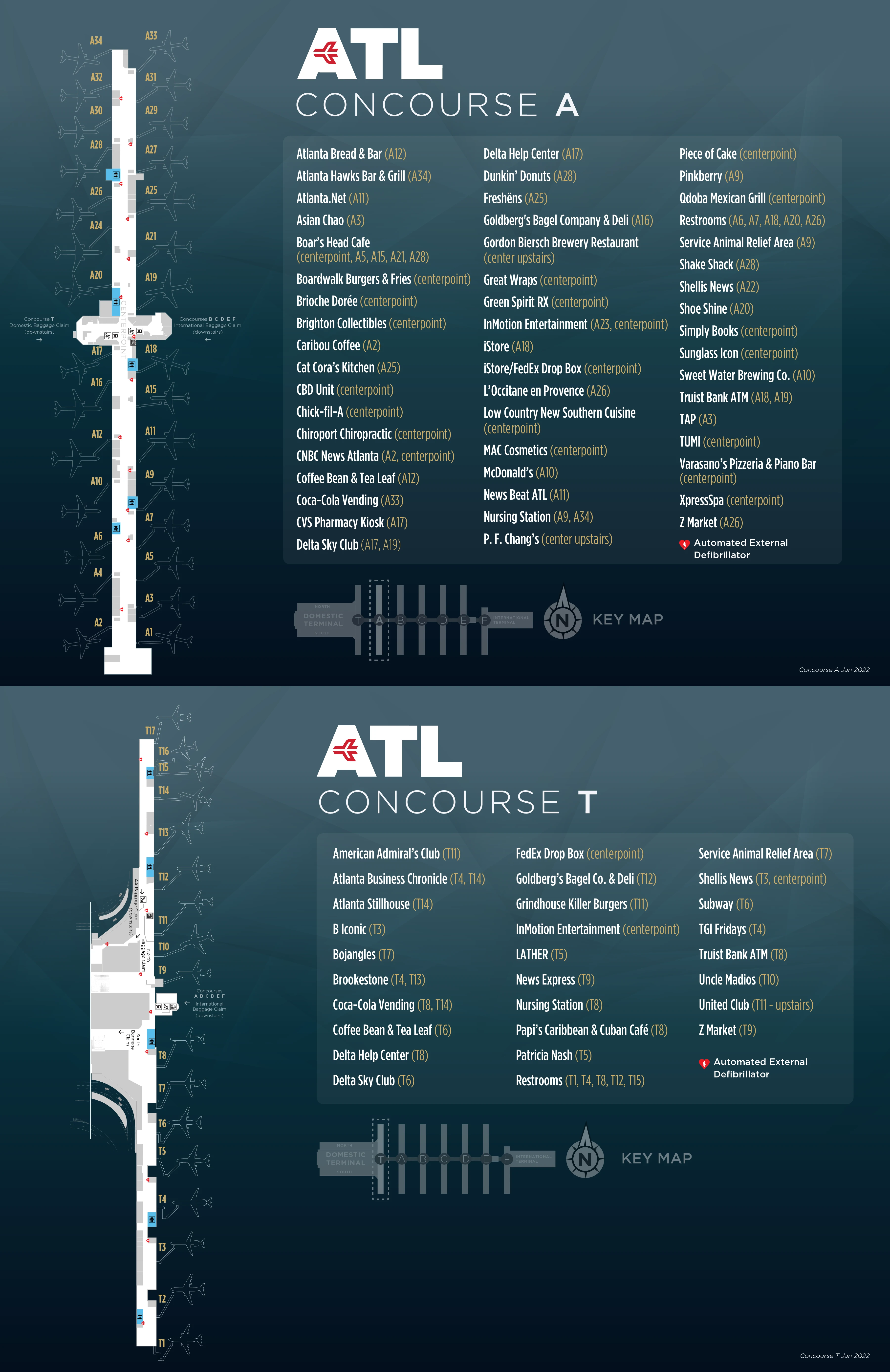
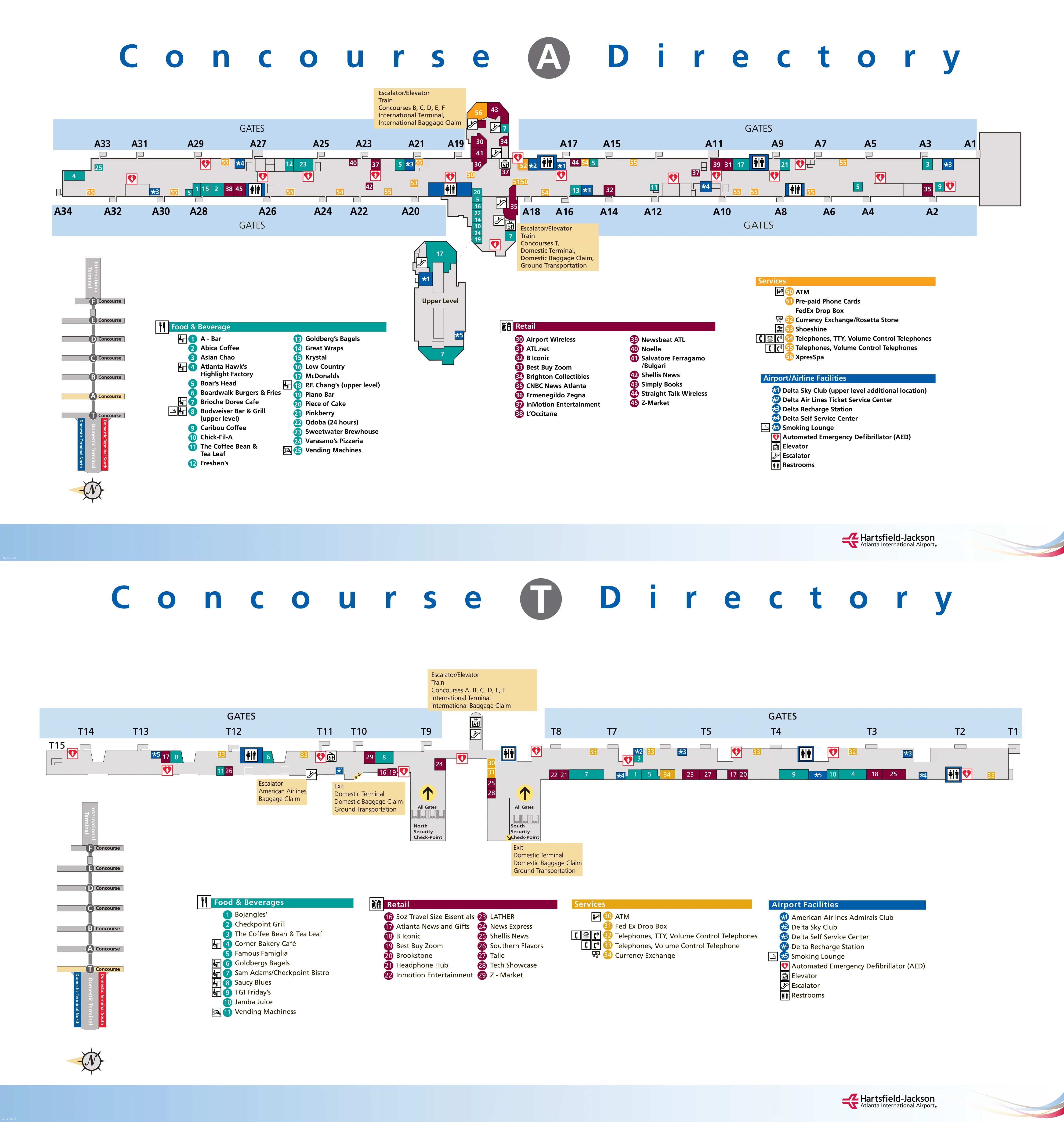
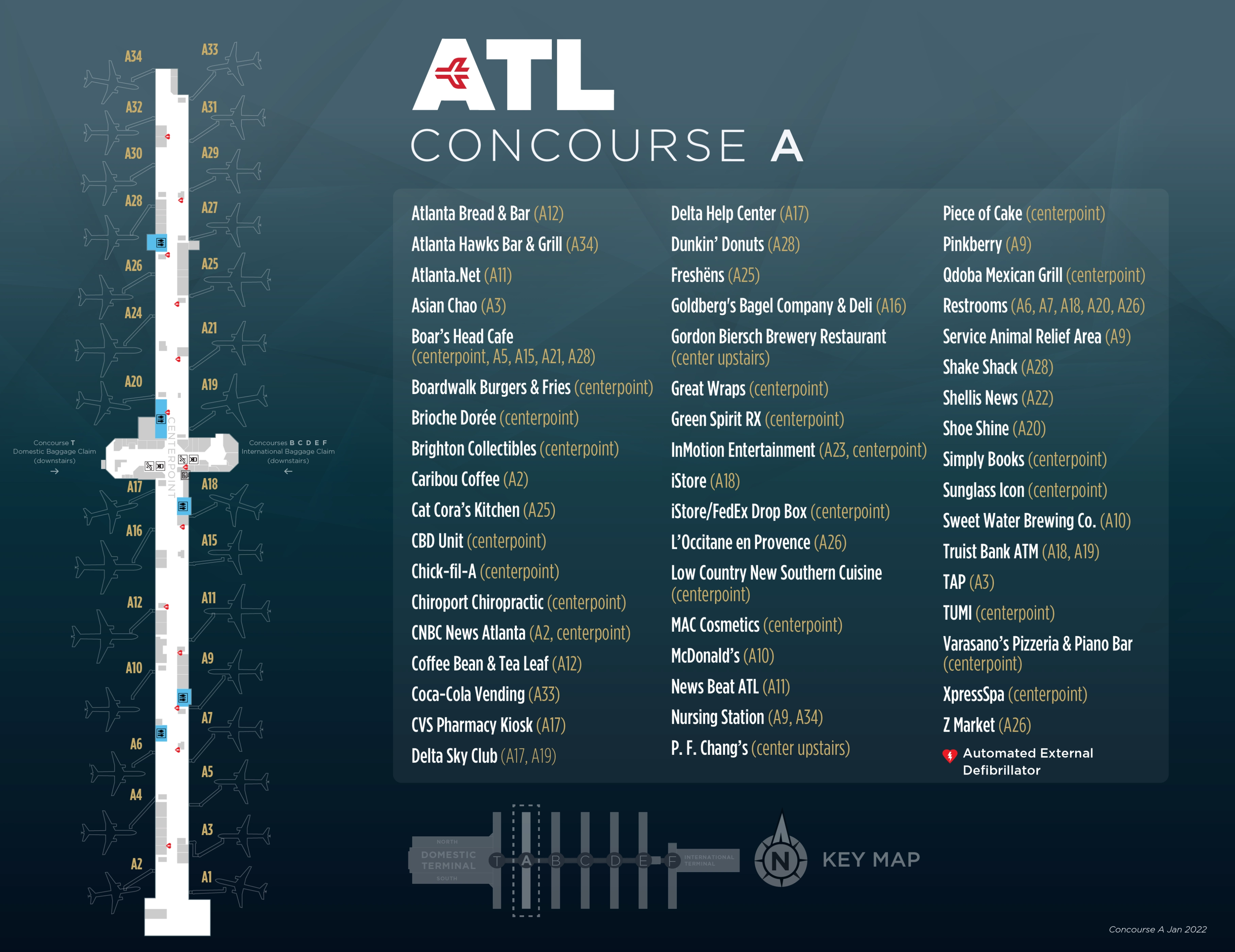
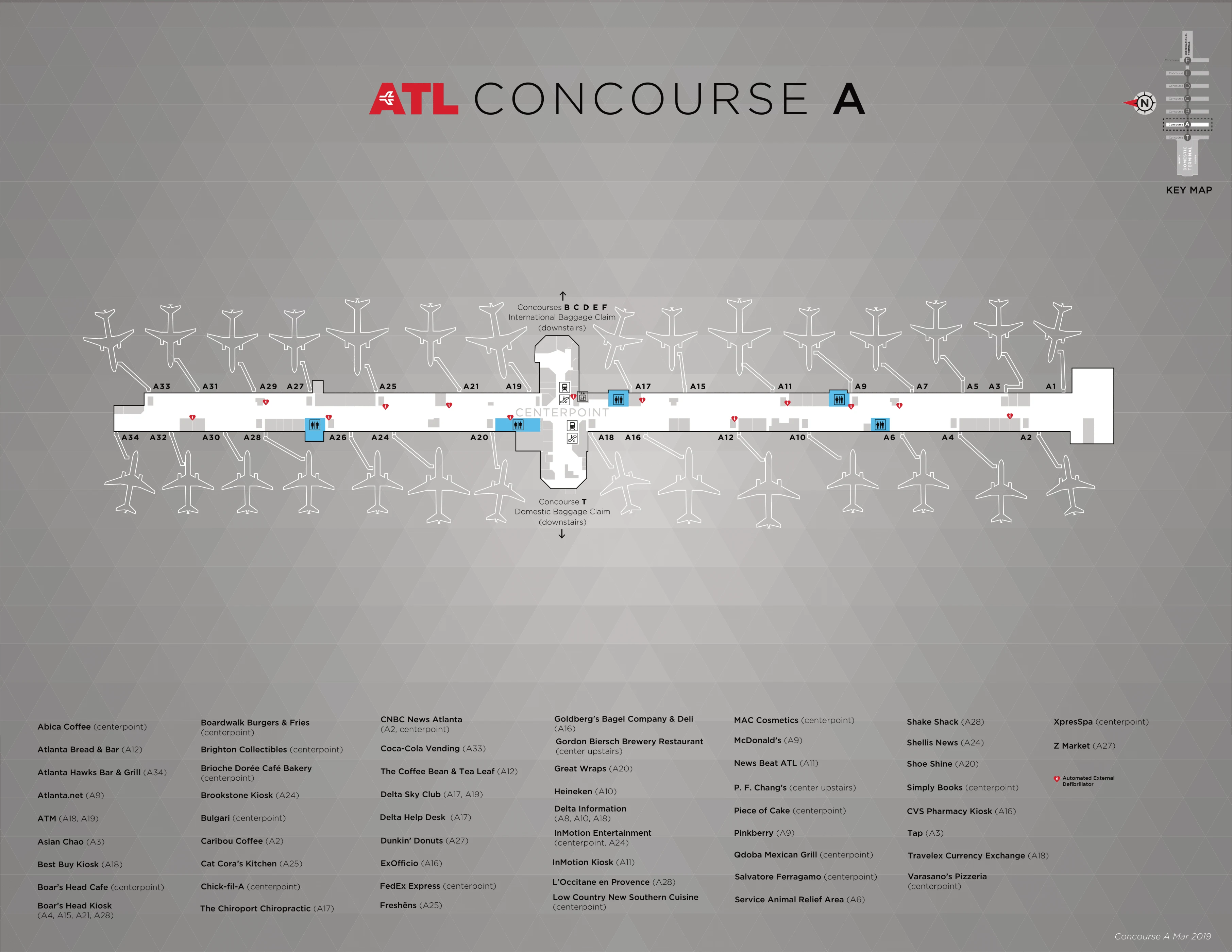
2025-2022 Hartsfield-Jackson Atlanta International Airport Terminal Domestic South Concourse A Map (Official 2022 Edition)
Hartsfield-Jackson Atlanta International Airport Terminal Domestic South Concourse T Map 2025-2022 (Official 2022 Edition)

2026 Hartsfield-Jackson Atlanta International Airport Terminal South Map Guide
What is the exact walking distance from Domestic Terminal South baggage claim to the Uber/Lyft pickup point (consolidated pickup zone)?
The walking distance is approximately 1,300–1,600 feet (0.25–0.30 miles) from the center of Domestic South baggage claim to the consolidated Uber/Lyft pickup in the North Economy Lot.
That range changes mainly by where you start in South baggage claim (which carousel you’re at) and how directly you hit the Atrium “West Crossover” before crossing into the North side. The route is forced: South baggage claim → walk west to the Atrium → cross to North → descend to Lower Level → exit at Door LN1/LN2 → follow the marked pedestrian path through the North parking-deck corridor → emerge into the North Economy pickup zones. With luggage, it typically maps to a 10–15 minute walk.
Which specific baggage-claim exit door yields the shortest mapped path to the rideshare pickup route (door-number exact)?
No South baggage-claim exterior door provides a true “short” Uber/Lyft path, because standard rideshare pickup is not permitted at the South curb.
The shortest mapped approach is to stay inside and bias west toward Door S1/S2 (the Atrium/MARTA end), then cross into the Atrium and continue to the North-side descent that leads to Door LN1 for rideshare egress. Door S1 is the best “orientation door” because it sits at the west end of South baggage claim and lines you up for the West Crossover without drifting toward the east-end S5/S6 doors that pull you away from the required North-side route.
What is the exact mapped location of the escalators used to access the rideshare route (the escalators that begin the walk to the pickup zone) relative to baggage claim doors?
The rideshare-route escalators are on the North side near the West Crossover, positioned by the Door N5/N6 area on the landside map, and they feed down to the Lower Level where you continue toward Door LN1/LN2.
From South baggage claim, the mapped setup is: move west inside the claim hall toward the Atrium (using the Door S1/S2 end as your “pull”), cross the Atrium into the North baggage-claim side, then look for Ground Transportation/Rideshare wayfinding that funnels you to the escalators in the N5/N6 vicinity. After descending, you’re directed to exit via Door LN1 (primary rideshare egress) before entering the parking-deck pedestrian corridor to the North Economy pickup zones.
On the ATL terminal map, what physical area does an itinerary label “Terminal S (Domestic South)” correspond to relative to concourses T–F?
“Terminal S (Domestic South)” corresponds only to the south half of the main terminal’s landside building—Delta ticketing/check-in on the Upper Level and Delta baggage claim on the Lower Level—at the far west end of ATL.
Concourses T–F are airside concourse buildings arranged in a straight sequence away from the main terminal, and they are not “inside” Terminal S. Concourse T is the only concourse physically attached to the main terminal, but it is still distinct from the Terminal S ticketing/baggage areas. For Concourses A–F, the map’s forced connector is the Transportation Mall/Plane Train level; you cannot reach A–F by staying on the ticketing level after security.
Where is the Priority/Sky Priority security lane entrance located relative to the main Domestic South checkpoint entry (exact position on landside map)?
The Priority/Sky Priority entry is effectively the far-right entrance cluster at the Domestic South checkpoint, where Digital ID and CLEAR sit, not a separate mid-lobby “Sky Priority” doorway.
On the landside map, it sits to the extreme right edge of the South checkpoint frontage when you’re standing in the South ticketing lobby facing the screening lanes. The most direct approach is to walk past the main central queue mouth and keep drifting right until you reach the dedicated right-side entry points for Digital ID/CLEAR, adjacent to the rightmost lane set. If you’re using the lower-level Digital ID bag drop, entering at Door LS1/LS2 and going up places you near that same far-right checkpoint entrance area.
From the Domestic South ticketing level, where is the nearest route to the Plane Train entrance (the exact corridor/escalator path shown on the map)?
The nearest route is the straight-ahead post-security funnel to the central escalator bank that drops from the checkpoint exit down to the Transportation Mall (Plane Train level).
From the South ticketing lobby, you enter the Domestic South checkpoint, clear screening, and then continue forward through the recompose area (shoe benches) without turning off toward concessions. The map’s forced move is the large down-escalator set directly ahead; those escalators take you to Level 0 where the Transportation Mall and Plane Train platform begin. The one exception is Concourse T: its gates peel off at the main-terminal level before you commit to the down-escalators.
What is the mapped walking distance from the security exit (Domestic South) to the Plane Train escalators (in feet/meters)?
The mapped walking distance is approximately 150 feet (about 45 meters) from the Domestic South security exit to the top lip of the Plane Train escalators.
That distance is the horizontal walk across the recompose area immediately after screening, where passengers regroup and put items back on. The escalators are the unavoidable choke point that drops you to the Transportation Mall; there is no level, same-floor walk to Concourses A–F from the South checkpoint exit. If you’re heading to Concourse T, you can peel off before the down-escalators, but the Plane Train path is straight ahead.
Where is the Digital ID line located in relation to the PreCheck and Clear lanes at Domestic South (exact lane position on checkpoint map)?
The Digital ID line is at the far-right edge of the Domestic South checkpoint, with CLEAR immediately adjacent to it on the right-side cluster, while standard PreCheck runs in the center/left lane set.
On the checkpoint map logic, think of the frontage as three blocks when you face the screening lanes from the South ticketing lobby: the far-right block is Digital ID first, then CLEAR right next to it; the middle-to-left block is the high-volume TSA PreCheck lanes. This placement matters because once you enter a central PreCheck queue, there’s rarely a clean cut-over to the far-right Digital ID/CLEAR entrance without backing out completely.
From the Plane Train station at Concourse F, what is the exact mapped path to the international curbside pickup doors (shortest route)?
The shortest mapped path is: exit the Plane Train at Concourse F, go up the station escalators to Arrivals (Level 1), proceed through passport control, collect bags at International Baggage Claim, then walk straight out to Doors A1/A2 for curbside pickup.
Once you’re on Arrivals, the flow is linear: Plane Train escalators up → CBP processing → bag claim → the opaque glass exit doors into the Arrivals Hall. The curb is immediately outside the Arrivals doors, and the most direct door targets for pickup are A1 and A2 (with A3 also serving the same curb line). Rideshare on the International side is curb-based, not a remote economy-lot walk.
Where are the South baggage-claim doors (S1–S6) positioned relative to the North-side door set (N1–N3 area) on the landside map (to prevent “wrong-side” exits)?
The South doors (S1–S6) are on the south face of the terminal and mirror the North doors on the north face, with the Atrium/West Crossover sitting between the North and South baggage-claim halls.
On the landside map, the key “wrong-side” prevention cue is that S-doors serve the Delta/South baggage-claim hall, while the N-door set serves the North baggage-claim hall for other carriers, and the two halls look deceptively similar. Within South baggage claim specifically, S1 is at the far west end closest to the Atrium/MARTA side, while S6 is at the far east end closer to the check-in curbside side. Staying oriented to the Atrium helps you avoid drifting into the North hall.
What is the exact route (as shown on the map) from the Domestic South arrivals curb to the Hourly Parking Deck elevators nearest baggage claim?
The route is: enter South baggage claim from the Domestic South lower-level curb, align to Doors S3/S4, use the crosswalks directly outside those doors to cross the lower roadway, then take the elevator bank in the central core of the South Hourly Parking Deck straight ahead.
On the map, S3/S4 are the “center doors” that line up with the parking-deck core, which is why they’re the shortest elevator access point. If you’re standing on the arrivals curb outside the South lower level, walking to the S3/S4 crosswalks first matters—those crosswalks land you closest to the deck’s main elevator shafts rather than forcing a longer garage-level walk from the west (S1/S2) or east (S5/S6) ends.
From Domestic Terminal South baggage claim, what is the exact mapped route to the MARTA station entrance (shortest indoor path)?
The shortest indoor route is to walk west through South baggage claim toward Door S1 (the Atrium/MARTA end), enter the Atrium at the West Crossover, and go directly into the MARTA Airport Station entrance between the North and South baggage-claim zones.
On the map, MARTA sits inside the building at the extreme west end of the Domestic Terminal complex, not outside at the curb. The path stays indoors the whole way: baggage claim → west toward the Atrium landmarks → MARTA entrance doors in the central Atrium corridor. From the middle of South baggage claim, this is typically a 300–400 foot indoor walk, and it avoids the rideshare parking-deck corridor entirely.
Archive Hartsfield-Jackson Atlanta International Airport Terminal South Map
Below are all historical map versions for Hartsfield-Jackson Atlanta International Airport. Each year includes the official map available for that period, presented as both WebP and PDF.
2022-2025 Hartsfield-Jackson Atlanta International Airport Terminal Domestic South Map (Official 2022 Edition)
2019 Hartsfield-Jackson Atlanta International Airport Terminal Domestic South Map
2013 Hartsfield-Jackson Atlanta International Airport Terminal Domestic South Map