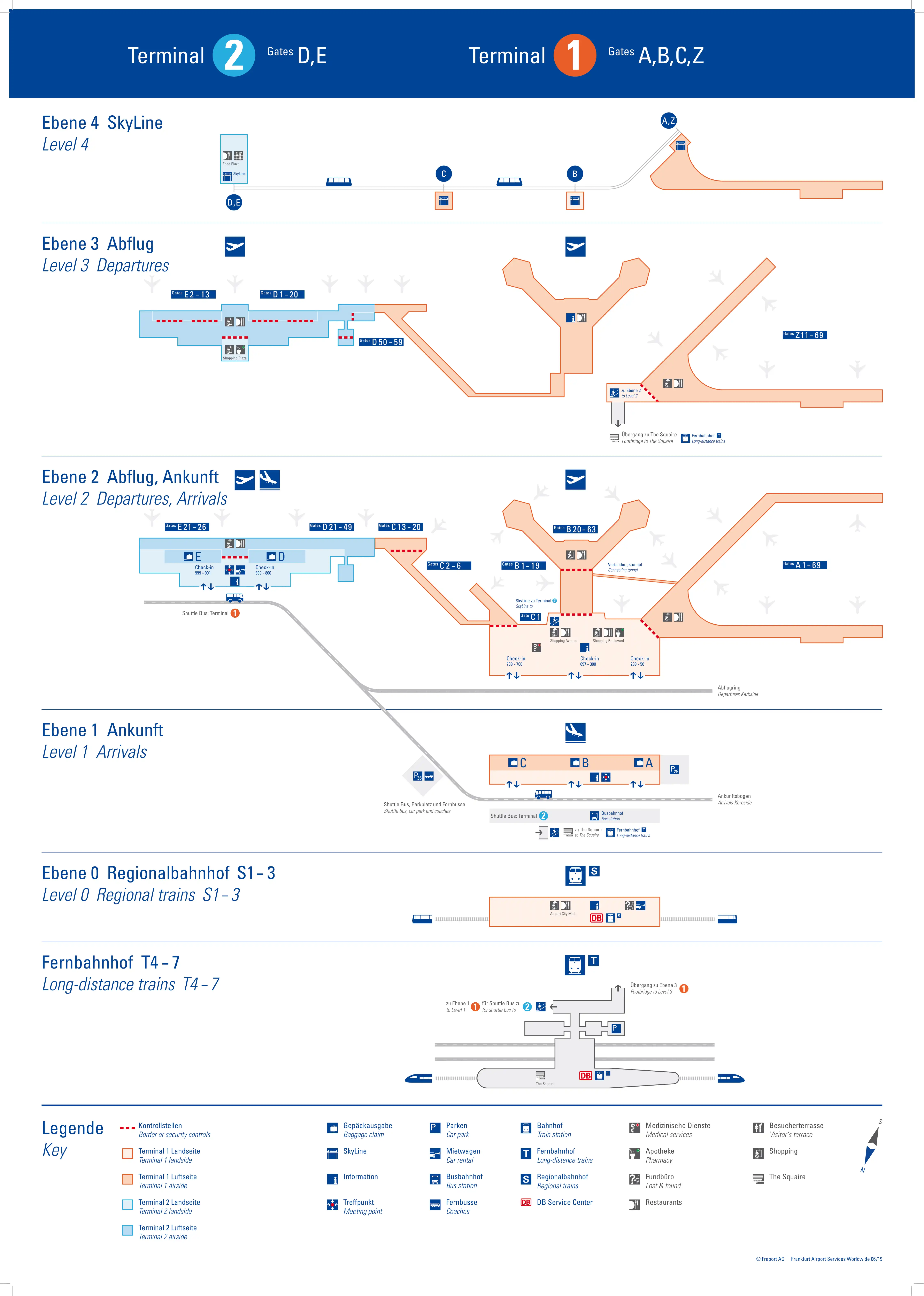
Frankfurt Airport Terminal Map (Most Up-To-Date)
Frankfurt Airport Hub (FRA) is a two-terminal complex with Terminal 1 as the dominant, multi-pier “spine” (A/B/C with the stacked A–Z levels) and Terminal 2 as a separate, east-side pier pair (D/E) across the apron. Most connection friction comes from vertical level changes and checkpoint placement inside Germany’s Frankfurt mega-hub—plus the fact that remote-stand bus arrivals can drop you into Hall B at a low, confusing starting level.
Map Table
| Terminal | Key Airlines | Primary Function | Transfer Mode |
|---|---|---|---|
| Terminal 1 (A/B/C/Z) | Lufthansa, Star Alliance | Main hub, Schengen/Non-Schengen split | A↔B tunnel, A↔Z passport filter, SkyLine to T2 |
| Terminal 2 (D/E) | oneworld, SkyTeam | Non-LH long-haul base, pier pair | SkyLine to T1, curbside transfer bus |
Frankfurt Airport Terminal Map Strategy
- Assume transfer variance first: passport control queues, extra security re-checks, and bus gates can appear without warning and change your starting node.
- Navigate by the high-risk split: Terminal 1 A/B/C/Z versus Terminal 2 D/E, with SkyLine stations as your “hard anchors” when the concourse letters stop making intuitive sense.
- Stay-airside on purpose: treat every “Exit / Ausgang” fork as a trap and follow “Connecting Flights / Transfer” signage toward tunnels, SkyLine platforms, and checkpoint corridors.
- Use transfer primitives, not vibes: default to SkyLine for T1↔T2, use the B↔A tunnel for Terminal 1 cross-pier moves, and plan vertical transitions (levels, escalators/elevators) as time-cost multipliers.
2026 Frankfurt Airport Terminal Map + Printable PDF
In 2026, FRA’s layout still hinges on Terminal 1’s A/B/C/Z zone logic and Terminal 2’s D/E piers, with SkyLine as the most reliable inter-terminal spine. Transfer outcomes remain driven by variable control points—passport control, occasional re-screening, and remote-stand bus operations—so a printable map is most useful when it highlights checkpoint nodes, SkyLine station levels, and the A/B tunnel entrances.
2026 Frankfurt Airport Map Guide
What is the exact walking distance (meters) from Terminal 1 “BSO” bus arrival to the A/Z transfer tunnel entrance?
Walking distance is approximately 150–200 meters from the Terminal 1 “BSO” bus-arrival exit point to the mouth of the A/B transfer tunnel (the stair/elevator access that drops you onto the tunnel level toward A15).
The BSO arrival node sits on Terminal 1 Hall B, Level 1 (Arrivals), so the real penalty is the forced vertical move and initial re-orientation in the B-arrivals manifold. From the bus door, follow “Connecting Flights A, Z / Transfer” (not “Exit / Ausgang”) to the vertical core near the B-arrivals center, then continue to the tunnel entrance area that feeds the underground corridor toward Concourse A near Gate A15.
Where is the airside passport-control checkpoint located for A → Z transfers, and what level is it on?
The primary airside passport-control checkpoint for A → Z transfers is at the root of Pier A/Z in Terminal 1 on Level 2 (Concourse A), near the A1/A11/A13 gate cluster.
Passengers moving from Schengen departures in A (Level 2) toward non-Schengen Z (Level 3) are funneled to this central Bundespolizei control bank near the hinge where the pier meets the main terminal building. After passport control, the standard flow is an escalator/elevator climb up to Level 3 (Concourse Z), where the Z-gate corridor begins. During the late-morning long-haul departure bank, queues can spill back into the A-level walking paths near those root gates.
Where is the alternate/secondary passport-control checkpoint for A/Z transfers (the one travelers miss due to poor signage), and which corridor leads to it?
The alternate A/Z passport-control checkpoint is near Gate A15 on Level 2 (Concourse A), close to the B↔A transfer-tunnel exit and adjacent retail (notably the Jack Wolfskin area).
The corridor that leads to it is the mid-pier A-level corridor you reach immediately after coming up from the B-to-A tunnel vertical core near A15. Many travelers mistakenly follow signs back toward the A1–A13 root for “Z Gates,” which pushes them into the main checkpoint queues. Instead, stay on the A15-area corridor and look for the nearby secondary control lanes and the vertical connection up to the Z level from mid-pier.
What is the shortest airside route distance from a typical Z arrival gate area to the A concourse departure gates (same building), measured gate-zone to gate-zone?
The shortest typical airside Z→A transfer inside the same A/Z building is about 1.6 km gate-zone to gate-zone when you’re arriving and departing from the common “far-pier” areas.
Because you generally can’t drop straight down from Z to A at the same pier position, the practical path is a V-shaped backtrack: walk from a typical long-haul Z gate cluster (for example, the far end around Z50–Z69) back to the root checkpoint zone near Z1/Z11, pass the passport-control filter to descend to Level 2 (A), then walk back out to the A gate zone (often again toward the far pier). In the best-case near-root pairing (around Z11 → A11), the transfer shrinks to roughly the checkpoint traverse (~50 m), but that’s not typical for widebody arrivals.
Where exactly are the SkyLine stations located in Terminal 1 and Terminal 2, and which concourse letters (A/B/C vs D/E) do they directly connect to?
SkyLine stations are on Level 4 and align to specific concourse “anchors” that determine which lettered pier you can reach fastest.
| Station | Exact location | Level | Direct concourse access |
|---|---|---|---|
| Terminal 1 A/Z | mid-pier on the A/Z spine | Level 4 | A (Schengen) and Z (Non-Schengen) |
| Terminal 1 B | central Hall B core | Level 2/3 access up to station | B (gates B-range) |
| Terminal 1 C | Concourse C station node | Level 4 | C (non-Schengen transit-focused) |
| Terminal 2 D/E | between Piers D and E | Level 4 | D and E concourses |
What is the exact distance from Terminal 2 arrivals exit to the Terminal-transfer shuttle bus stop, and which door/curb zone is it closest to?
Walking distance is under 50 meters from the Terminal 2 arrivals/customs exit to the terminal-transfer shuttle bus stop, which sits curbside outside Hall E closest to Exit/Door 8 (between Exit 8 and Exit 9).
After you clear arrivals in Terminal 2, stay on the same level to the curb (no vertical transitions) and aim for the Hall E exits. The stop is positioned immediately outside that doorway cluster, so the path is essentially a straight curb walk once you’re out of the sliding doors. This is the lowest-friction option for heavy luggage compared with going up to Level 4 for SkyLine.
From Terminal 2 (D/E), what is the shortest mapped path (and distance) to the Fernbahnhof (long-distance rail station)—SkyLine route vs walking connectors?
The shortest mapped path from Terminal 2 (D/E) to the Fernbahnhof is via the terminal-transfer shuttle bus, with about 300–350 meters of walking plus the bus ride.
| Route | Walking segments | Ride segment | Practical path anchors |
|---|---|---|---|
| Shuttle bus (shortest walk) | ~300–350 m | ~10 min bus to Terminal 1 Arrivals | T2 Hall E Exit 8 → curbside bus stop → T1 Arrivals → Hall B core → connector to Fernbahnhof |
| SkyLine (more walking/vertical) | ~500 m + multiple level changes | ~2–3 min train ride | T2 Arrivals Level 2 → up to Level 4 SkyLine → T1 B station → down into Hall B → walk to rail connector → Fernbahnhof |
Where is the security re-check checkpoint placed on the Terminal 1 ↔ Terminal 2 airside transfer flow, and which direction(s) trigger it?
A security re-check can be forced at the Terminal 2 SkyLine station exit corridor on Level 4, where arriving transit passengers are filtered before entering the main D/E gate area.
The trigger is primarily your arrival-origin security status (clean/OSS vs non-OSS), not whether you’re traveling T1→T2 or T2→T1. When a passenger from a non-OSS (“unclean”) origin uses SkyLine into Terminal 2, the post-platform corridor funnels them into a security checkpoint before they can access Concourse D/E. “Clean” arrivals are typically routed via a bypass corridor—unless they accidentally follow “Exit / Baggage Claim” signage and break the sterile flow.
What is the exact walking distance from Terminal 1 Concourse B to the A/Z connector (including the required vertical transitions: stairs/escalators/elevators)?
Walking distance is approximately 450–500 meters from the central Concourse B/Hall B area to the A-side A/Z connector at Gate A15, including the required down-and-up vertical transitions.
The mapped airside path runs from the Hall B core near the Meeting Point / B-arrivals manifold to a vertical core (escalator/elevator) down to the U1 tunnel level, then through the straight B↔A transfer tunnel (about 350–400 m)—often with moving walkways—followed by the ascent on the A side to Level 2 (Concourse A) near A15. This is the same node that feeds the secondary A15 passport-control option for fast Z-level access.
On the Terminal 1 map, where are the “wrong-way” exit forks that accidentally send transferring passengers toward landside/passport exit instead of airside transfer?
The highest-risk “wrong-way” forks are in Terminal 1 Hall B arrivals, around the B-arrivals manifold between the B13–B19 arrival-flow area, where dominant signage and crowd flow pull passengers toward “Ausgang / Exit” and Baggage Claim instead of “Connecting Flights / Transfer.”
These traps appear right after you emerge from the B-side arrival corridors or the BSO bus-arrival injection node into the central Hall B space. The safe path is the smaller “Transfer / Connecting Flights A, Z” direction that leads to the elevator/stair banks for the B↔A tunnel. If you pass one-way doors into the landside zone, you’ve effectively committed to re-entering via departures and re-clearing general security.
Where are the bus-gate departure lounges (areas labeled for bus boarding / remote stands) relative to main concourse gates, and what’s the shortest connector path to them?
Bus-gate departure lounges in Terminal 1 sit one level below the main concourse promenades, clustered in recessed “bus zones” reached via down cores rather than along the windowed gate spine.
- Concourse B bus gates: ground/operational level pockets often signed as B-range bus gates (commonly described as B-West/B-East), reached by descending escalators near the B concourse gate-range signs.
- Concourse A bus gates (ASO): beneath the A pier, with access cores distributed along the pier, including near the A-root area around A5 and toward the A-Plus side.
- Shortest connector path: from your nearest gate cluster, stop at the first overhead sign that breaks out a bus-gate range and take the adjacent escalator/elevator core down to the lounge level rather than walking farther down the pier looking for a jet bridge.
These lounges function like holding pens; the time cost is driven by the vertical descent and the controlled boarding funnel, not just horizontal distance.
What is the shortest mapped distance from Terminal 1 A concourse to Terminal 2 D/E concourses using SkyLine, including the station-to-station walking segments?
The shortest mapped T1 A→T2 D/E transfer using SkyLine involves about 400–500 meters of walking (plus vertical transitions), with the train covering roughly 1.8–2.0 km of track.
The practical segment math is: walk from a mid-A node (for example around A20) to the Terminal 1 A/Z SkyLine station (~200 m) and go up to Level 4, ride SkyLine to Terminal 2 D/E station (2–3 minutes), then walk from the station down and into the D/E concourse level to a typical near-station gate area (~200 m). The predictable part is the rail ride; the variable part is station access time (elevators/escalators and platform routing).
Archive Frankfurt Airport Terminal Maps
Below are all historical map versions for Frankfurt Airport. Each year includes the official map available for that period, presented as both WebP and PDF.
2019-2025 Frankfurt Airport Terminal Map (Official 2019 Edition)
2014 Frankfurt Airport Terminal Map