Vancouver International Airport Map (Most Up-To-Date)
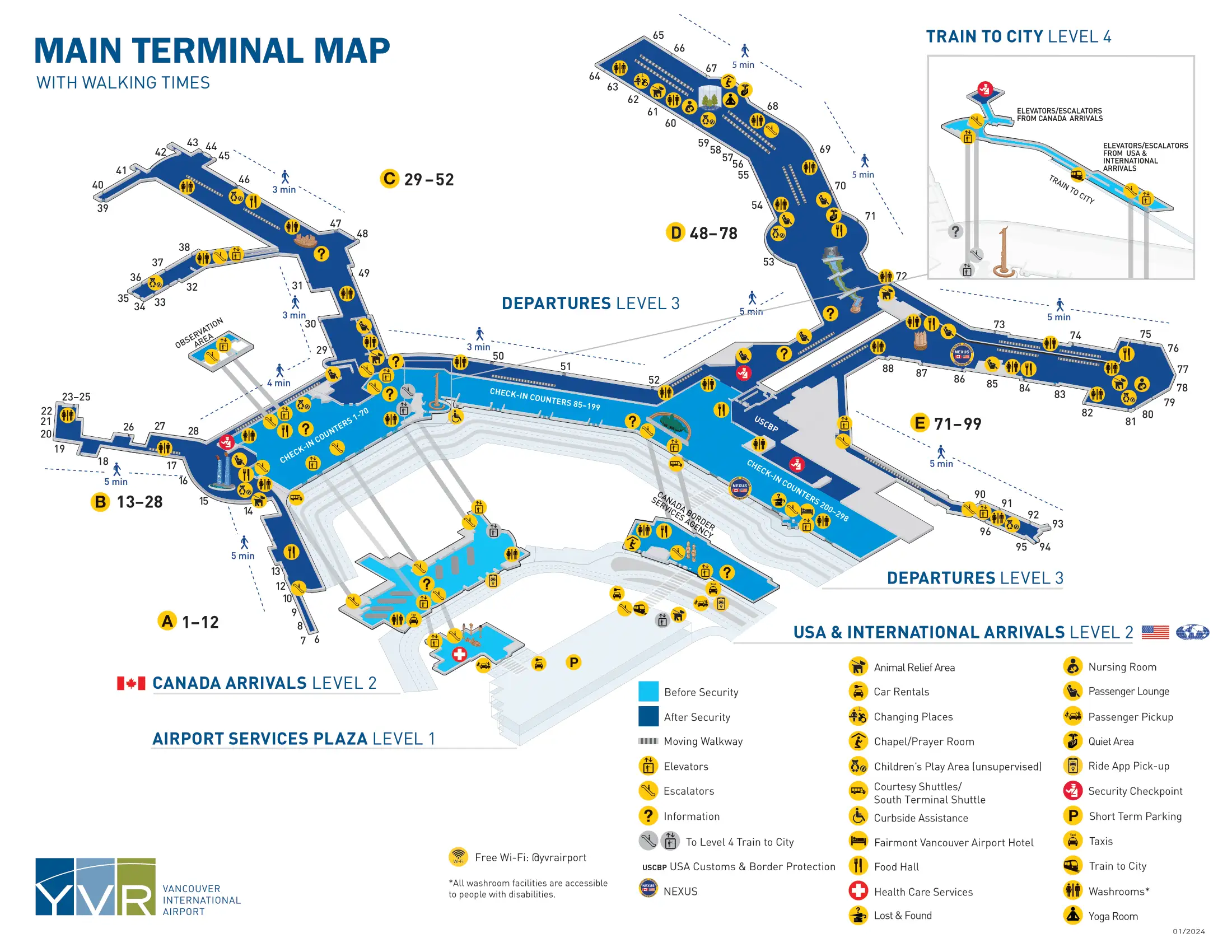
Vancouver International Airport (YVR) uses a compact, Y-shaped layout with a central landside spine that splits into Domestic piers (A/B/C) and the International + Transborder side (D/E). Most “time risk” happens at a few chokepoints rather than long walks: CATSA screening, US preclearance, and arrivals processing. Within Vancouver’s primary airport hub, level changes matter as much as distance—Level 4 (Canada Line), Level 3 (departures), Level 2 (arrivals), Level 1 (rental cars in the parkade).
Map Table
| Terminal | Key Airlines | Primary Function | Transfer Mode |
|---|---|---|---|
| Domestic A/B/C | Air Canada, WestJet | Canada departures, domestic connections | walk concourse, C-hub pivot |
| International D | major international carriers | non-US international departures | walk spine, D checkpoint |
| Transborder E | Air Canada, United, American | US departures, US connections | security + CBP preclearance |
| Landside spine | all carriers | check-in, arrivals exits, Canada Line link | level change, short curb walks |
Vancouver International Airport Map Strategy
- Navigate by zones first, then gates: Domestic A/B/C vs International D vs Transborder E, with the US preclearance boundary treated like a hard wall you can’t casually cross back through.
- Reduce security time-risk by routing to the correct checkpoint entrance using fixed anchors in the departures hall (Jade Canoe for D, US counters/large “E” portal for E).
- Treat connections as “decision points,” not hallways: if you pass through public glass exits at arrivals, you’ve usually lost the airside path and will trigger re-screening.
- Pre-plan friction runs: washroom before US preclearance, NEXUS lane entry position, baggage-to-curb shortest exit, and the parkade down-one-level move for rental cars.
2026 Vancouver International Airport Map + Printable PDF
Current navigation at YVR in 2026 still hinges on fixed zone boundaries: Domestic (A/B/C), International (D), and the US preclearance enclave (E). The map you print should highlight decision nodes that prevent “wrong side of the wall” mistakes—especially where US connections and Canada connections split before you hit public exits. Treat queue areas as spatial features: you’re navigating to the start of a line, not just a gate.
2026 Vancouver International Airport Map Guide
What is the exact walking distance (meters) from YVR Canada Line station entrance to the Domestic check-in hall?
The walking distance is 350 meters (±30 m) from the Canada Line fare-gate exit to the Domestic check-in hall on Level 3. The route starts on Level 4 at the YVR–Airport station, then uses the Link Building bridge and a single vertical drop to reach the check-in counters.
Follow the overhead split immediately after the fare gates and choose “Domestic Terminal,” then stay on the enclosed connector walkway until it ends at the Link Building vertical core. Descend one level by escalator/elevator to the Level 3 landing, where the Domestic check-in counters (Air Canada/WestJet) come into view along the left side. It is not possible to reach check-in without dropping to Level 3.
Where is the US departures (E Gates) security checkpoint entrance located relative to the main departures hall (which landmark/store is the closest fixed reference)?
The US departures security entrance is on Level 3 in the central departures hall beside the US check-in counters (Rows 200–299), marked by a large illuminated “E” portal. It is a separate entrance from the International (D Gates) checkpoint.
From the main departures hall, walk toward the section where US airline check-in dominates and the “E” overhead designator becomes the primary beacon. The most reliable fixed reference is the bank of US check-in desks themselves, with prominent USCBP / US Departures signage at the portal; if you’re standing by the Jade Canoe (International landmark), you are not at the E-gates entrance yet and must continue down the hall toward the US counters.
What is the exact walking distance (meters) from the Domestic security exit to the start of the US preclearance queue (first CBP line point)?
A US boarding pass is required to enter the US Connections corridor; without it, you must go landside and re-enter at the main E-gates checkpoint. The airside walking distance from the Domestic side to the first CBP line point is 180 meters (±20 m) using the US Connections route near the C29/C30 area.
| Route segment | Anchor point | Distance |
|---|---|---|
| Domestic concourse to US Connections portal | near Gate C29/C30, first overhead “US Connections / E Gates” sign | short approach |
| US Connections corridor traverse | corridor running from Pier C root toward Pier E root | majority of the 180 m |
| Connection screening to CBP line start | immediately after the dedicated connection security exit | short final push into the first stanchions |
What is the exact walking distance (meters) from the International Arrivals exit to the Canada domestic connections route decision point (the first place you must choose a corridor/turn)?
The walking distance is 70 meters (±10 m) from the International Arrivals exit into the baggage hall to the first Canada domestic connections decision point. The decision point is the Canada Connections split beside the connections bag-drop belt, just before the public glass exit doors.
After CBSA processing, pass through the frosted doors into the International baggage claim hall, keeping the carousels on your left as you move toward the “Exit / Secondary Inspection” end of the room. The first forced choice appears at the connections bag-drop area where “Canada Connections” signage pulls you into a right-hand corridor/turn before the main glass doors to the public meet-and-greet. If you walk straight through those glass doors into the crowd, you’ve missed the airside connections path and will be pushed into landside routing and re-screening.
Where exactly does the “US Connections” airside route begin for passengers arriving from Domestic gates (the first posted sign/portal location)?
The “US Connections” airside route begins on Level 3 at the Pier C hub beside Gate C29/C30, where the first overhead “US Connections / E Gates” sign points into a side corridor. That portal is before any descent to arrivals and before the public exit flow.
Walk toward the root of Pier C until you’re in the Gate C29/C30 area, where the concourse widens and overhead signs split flows. The entry you want is a lateral corridor staying on Level 3, typically marked with “US Connections” and E-gates directioning near that junction.
If you reach the “Exit / Baggage Claim” escalators or start descending toward Level 2, you’ve passed the last usable decision point and will be forced into landside re-entry routing.
Where is the NEXUS / expedited lane entrance physically located within the US departures screening area (which side, which stanchion merge point)?
The NEXUS / expedited lane entry is on the far left side of the US departures checkpoint stanchions when you are facing the screening entrance. It is accessed before you enter the main serpentine queue, with the lane identified by NEXUS/Trusted Traveller markings on overhead monitors/signs.
Approach the E-gates security portal on Level 3 and stop at the first stanchion mouth where the queue splits. The expedited stream peels left into its own roped lane, then continues through screening and into the CBP processing hall without merging back into the general line during the security + kiosk phase. The first practical merge is only after the CBP officer release, near the retail/duty-free area—once you commit into the general queue ropes, you cannot cut across to the left.
What is the exact walking distance (meters) from Gate C (domestic pier midpoint) to Gate E (US pier midpoint) using the shortest airside path?
Security screening plus US preclearance are mandatory mid-route, so you cannot “just walk” from Pier C to Pier E without entering the processing zone. The shortest airside walking distance is about 630 meters from a midpoint like Gate C40 to a midpoint like Gate E80, not counting time spent standing in queues.
| Segment | Anchor point | Distance |
|---|---|---|
| Gate C midpoint to Pier C hub | from around Gate C40 toward the widened junction near Gate C29/C30 | ~200 m |
| US Connections corridor | portal at Gate C29/C30 area to the Pier E root corridor | ~180 m |
| Processing corridor walk | connection screening exit through the CBP hall to the officer-release point | ~50 m |
| Pier E root to Gate E midpoint | from the retail/root area in the E70s down the concourse toward Gate E80 | ~200 m |
Where is the International (D Gates) security checkpoint entrance located relative to the main departures hall (nearest fixed landmark)?
The International (D Gates) security entrance is on Level 3 directly behind/adjacent to the “Spirit of Haida Gwaii” Jade Canoe sculpture in the main departures hall. It is the checkpoint you use for non-US international flights and is distinct from the US (E Gates) portal farther down the hall.
Approach the central departures hall and use the Jade Canoe as the fixed visual anchor; the D-gates screening entrance sits immediately on the terminal side behind that sculpture, near the International check-in counter banks (lower-numbered counter ranges) and typical service points like foreign exchange. If you’re standing at the large illuminated “E” portal near US counters 200–299, you’ve gone past the D-gates entry.
What is the exact walking distance (meters) from Gate D (international pier midpoint) to the closest washroom outside US preclearance (pre-queue)?
The closest pre-queue washroom is about 20 meters from the US preclearance queue entrance if you’re entering via the airside US Connections facility, and about 50 meters if you’re approaching from the landside departures hall. This is the last reliable restroom stop before you commit to the security + CBP processing tunnel.
From the International side, the practical tactic is to target the restroom that sits adjacent to the US checkpoint entry area rather than hunting deeper in Pier D. The fixed anchor is the US departures portal area: position yourself near the E-gates entry signage, then look immediately alongside the checkpoint approach for the washroom doors before the stanchions begin. Once you step into the queue field, leaving to use a restroom usually means surrendering your place and restarting the line.
Where is the baggage claim hall entrance located relative to the main Arrivals exit (which corridor/turn leads into the first carousel sightline)?
The baggage claim hall entrance is reached by following “Baggage Claim / Exit” signs to Level 2 and stepping through an open threshold where the first carousel sightline appears immediately. The key difference is domestic arrivals have a straight descent into baggage claim, while international arrivals only see baggage claim after clearing CBSA and passing through frosted/glass doors.
Domestic arrivals flow down the main escalator bank from Level 3 and the carousels appear right ahead at the bottom, anchored by the Musqueam Welcome Figures near the arrivals threshold. International arrivals pass the CBSA Primary Inspection Line first, then the first carousel sightline appears immediately after the border podiums as you enter the baggage hall through the controlled doorway. In both cases, there is no “long corridor” to find the first carousel—if you’re walking laterally for a long stretch, you’ve likely taken the wrong exit stream.
What is the exact walking distance (meters) from Baggage Claim to the ground transportation / taxi stand exit using the shortest signed route?
The walking distance is 50–75 meters from the baggage claim hall exit doors to the taxi stand using the shortest signed route. The route is mostly straight and relies on taking the first curbside exit immediately after you enter the public Arrivals hall on Level 2.
Exit the baggage hall through the one-way doors into the public meet-and-greet space, then angle directly to the nearest automatic glass doors to curbside rather than walking down the length of the terminal. Outside, cross the immediate lane(s) to the designated taxi queue area, anchored by the taxi marshal booth and curb paint/queue markers. If you follow signs for ride-app pickup instead, you can be routed farther away or to a different level depending on current curb management.
Where are the rental car counters located relative to the terminal exits (exact level + which parkade entry point is the fastest)?
The rental car counters are on the Ground Floor of the Main Parkade (Level 1 / P0), not inside the terminal. The fastest entry is to exit the terminal on Arrivals Level 2 and walk straight across the crosswalk into the parkade, then immediately drop down one level by the parkade elevator/escalator.
From the main Arrivals hall, use the primary glass exit doors to curbside and keep moving forward under the weather canopy to the pedestrian crossing directly opposite the terminal. You enter the parkade still aligned with Level 2, then the first required move is vertical: descend to Level 1/P0 where the clustered rental desks (National/Alamo/Hertz/Avis, etc.) sit in the dedicated Car Rental Centre zone. A reliable confirmation anchor near the rental center area is the 7-Eleven on the lower level.
What is the exact walking distance (meters) from the US preclearance exit to the nearest lounge inside the US departures zone (shortest airside route)?
The walking distance is 250 meters (±25 m) from the US preclearance exit to the Air Canada Maple Leaf Lounge in the US departures zone, with Plaza Premium at about 280 meters. The start point is the CBP officer-release exit into the duty-free/retail hub at the root of Pier E.
Exit CBP and continue forward through the duty-free retail channel until you reach the main Pier E concourse flow, then follow lounge signage down the linear pier. The closest lounge target is the Maple Leaf Lounge between Gates E84 and E86; Plaza Premium is nearer Gates E87/E88. The fixed triangulation is gate numbering: you typically exit preclearance around the E70s root area, and the lounges sit deeper into the E80s, requiring a committed walk down the pier.
Where is the first connections re-screening checkpoint located for International → Domestic transfers (the first physical queue/stanchions after following the connections signage)?
You must re-clear security for International → Domestic transfers, remembering that duty-free liquids only survive if they’re in compliant sealed bags. The first re-screening checkpoint is on Level 3 at the top of the Canada Connections elevator/escalator, where you are deposited directly into the Domestic security queue stanchions.
After CBSA and the Canada Connections bag-drop area on Level 2, follow the “Connections” routing to the vertical lift back up to departures. When you arrive on Level 3, the queue field begins immediately—look for the stanchions and screening entry that feed the Domestic checkpoint (Checkpoint C) rather than any gate corridor. If you instead exit through the public glass doors on Level 2, you lose the controlled connection path and will be forced to navigate landside back to departures and re-enter screening from the front.
Archive Vancouver International Airport Map
Below are all historical map versions for Vancouver International Airport. Each year includes the official map available for that period, presented as both WebP and PDF.
2024-2025 Vancouver International Airport Map (Official 2024 Edition)