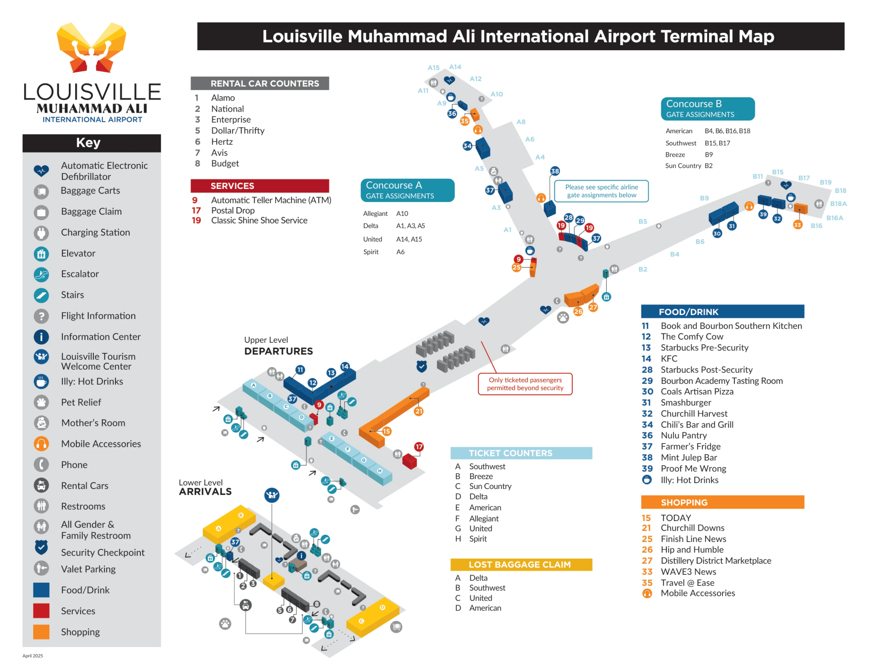
Louisville Muhammad Ali International Airport Map (Most Up-To-Date)
Louisville Muhammad Ali International Airport is a compact “hourglass” terminal: one central landside core (ticketing + security) that funnels everyone into a single checkpoint, then splits airside into Concourses A and B around the Rotunda. The building runs roughly east–west, with arrivals/baggage claim on the lower level and ticketing/departures above. Within Louisville’s primary air-travel hub, most navigation problems happen at the choke points—security, baggage claim ends, and curb-level choices.
Map Table
| Terminal | Key Airlines | Primary Function | Transfer Mode |
|---|---|---|---|
| Jerry E. Abramson Terminal | Southwest, Delta, American, United | Single landside core, single checkpoint | Walk, vertical escalators/elevators |
| Concourse A | Delta, United, Allegiant | Gates A1–A15 | Walk via Rotunda |
| Concourse B | Southwest, American | Gates B2–B18 | Walk via Rotunda |
| Lower Level (Arrivals/Baggage) | All arrivals | Carousels, ground pickup interfaces | Door-based curb zones, rideshare geofence |
Louisville Muhammad Ali International Airport Map Strategy
- Treat security as a single-throat system: overflow doesn’t create a “new” line, it just stretches; the only winning move is joining at the correct landmark before the stanchion corridor locks you in.
- Make the PreCheck vs. standard decision at the queue entry landmark; once you enter the wrong stanchioned lane, there’s no mid-stream crossover without fully exiting and backtracking.
- Run baggage claim like an east/west problem: commit to the correct end early (Carousels 1–2 west, 3–4 east) and use the nearest overhead carousel monitor instead of wandering belt-to-belt.
- Use curbside as door-specific routing: rideshare only works from the west-side baggage claim exits (geofenced), and missing the cell phone lot split before the terminal loop forces a full recirculation penalty.
2026 Louisville Muhammad Ali International Airport Map + Printable PDF
Active SDF Next construction in 2026 keeps the terminal “hourglass” feeling: the checkpoint area is channelized into long, single-file queue geometry, and space that used to absorb overflow is tighter. Treat the map like a decision-node tool—security entry landmarking, door-specific curb exits, and east/west baggage claim orientation—so you don’t burn time on recirculation loops or landside backtracking.
2026 Louisville Muhammad Ali International Airport Map Guide
Where is the physical start point of the standard TSA queue during peak morning overflow (the exact landmark where people first “join the line”)?
The standard TSA queue starts at the Starbucks area in the Central Ticketing Hall, where the stanchions form the queue entry throat. During peak morning overflow, the “join here” tail stretches westward from that Starbucks/central elevators landmark, running past the “TODAY” store and then behind the American/United/Spirit counter zone.
The correct behavior is to walk to the Starbucks-side stanchion mouth and then follow the single-file line west as needed, not to invent a new tail near the ticket counter doors. The overflow line visually looks like it begins near the “TODAY” store, but that’s just the extended tail; the controlling entry landmark is still the Starbucks and the tall central elevators beside it.
Where is the first physical divergence between PreCheck and standard screening (the exact spot where choosing wrong forces a backtrack)?
The first divergence happens at the TSA queue entry point by Starbucks in the Central Ticketing Hall, before you enter the stanchioned corridor. Two parallel single-file lanes begin there—one signed for TSA PreCheck and the other for General Screening—and once you step into the wrong stanchioned lane, you cannot cross over mid-stream.
Choosing wrong is costly because the lanes run side-by-side through the construction channel with rigid barriers, and the first staffed processing point (the document checker podiums) is downstream. If you have PreCheck, you must self-sort at the Starbucks landmark where the stanchions split; entering the general lane traps you behind general passengers until the corridor ends, forcing a full exit-and-rejoin to correct it.
Which exact exterior door/curb segment corresponds to the “west side of baggage claim” rideshare pickup instruction for Uber/Lyft?
Uber/Lyft pickup is on the far west end of the lower-level baggage claim exits—centered on Door 1 and the adjacent unnumbered west-side side exits past Carousel 1. Exiting anywhere near the middle doors by the Information Booth puts you outside the rideshare geofence and typically leads to driver cancellations.
The fastest triangulation is to commit to the west end of the baggage hall (Carousels 1–2 side), walk past Carousel 1, and leave through Door 1/west side doors into the Commercial Ground Transportation loading area. After exiting, don’t wait at the inner private-car curb; cross the first lane to the designated outer/commercial curb or median loading zone used for TNC vehicles.
What is the exact turn-by-turn access point (road/turn/entrance) to the cell-phone/Express Shuttle waiting lot described as “past departures” and poorly signed?
The cell phone waiting area is reached by taking the right-hand split off Terminal Drive before you ever enter the terminal loop, following the “Hotel / Express Lot / Cell Phone Lot” signage. Missing that right exit forces you into the arrivals/departures curb loop, where waiting is prohibited and the penalty is a full recirculation.
| Step | Decision node | What to do |
|---|---|---|
| 1 | Terminal Drive approach, terminal visible left | Stay in the right lane; ignore the left-banking Departures/Arrivals gantries |
| 2 | Bifurcation ~400 meters before the canopy | Take the right-hand exit signed “Hotel / Express Lot / Cell Phone Lot” onto the service/administration road |
| 3 | Service road corridor with shuttle-bus presence | Continue parallel to the main loop; look for two quick right-side entrances |
| 4 | First right entrance | Skip/avoid confusing it with the goal; it’s the Express Shuttle Parking Lot |
| 5 | Second right entrance immediately after | Turn right into the Cell Phone Waiting Area entrance |
Where is the pedestrian path entry from East Premier / West Premier parking that minimizes road-crossing and avoids wandering the garage frontage?
The best pedestrian injection points are the covered walkway entrances at the northeast corner of Premier West and the covered walkway line from Premier East into the east end of the baggage claim hall near Carousels 3 and 4. These routes keep you on designated crossings and drop you into a known vestibule instead of drifting along the garage frontage.
Premier West works by walking to the lot’s northeast corner, taking the covered walkway across the commercial roadway, and entering the lower level through the West Vestibule near the rideshare pickup zone. Premier East works by following the covered walkway system to the terminal’s east-end lower-level entry, landing near the Carousel 3–4 area. From either entry, use the nearest elevator/escalator bank inside the vestibule to go up to ticketing rather than trying to “find” ticketing by walking along the curb.
What is the exact curbside segment on the upper/departures level that functions as the “easier pickup” alternative when arrivals is backed up?
The easiest upper-level pickup zone is the far east departures curb beyond the Delta/Southwest ticketing doors or the far west departures curb beyond the United/American doors. These end segments stay clearer because most drivers stack in the central curb lanes, and late-evening departures traffic is typically lighter.
The practical move is to avoid the middle departures curb by the main doors and instead have the passenger go up from baggage claim to ticketing and walk out to one of the extremities. The key negative constraint is that stopping in the center zones recreates the same dwell-time congestion pattern as arrivals; the end segments buy a short 2–3 minute dwell window without blocking the main flow.
Which specific TSA lanes/checkpoints are physically present but sometimes closed/limited (the exact location of the bottleneck driving “inconsistency”)?
Lane 5 and Lane 7 at the single central TSA checkpoint are the most frequently limited or closed, because they sit on the operational periphery and are often repurposed for Known Crew Member or employee access. When they’re offline, the checkpoint’s effective capacity drops sharply and the single-file queue lengthens fast.
The bottleneck effect is amplified because odd-numbered lanes tend to host secondary screening equipment in the end “dead space,” so an alarm event can pause that entire lane while a manual check is performed. If you have any lane choice at the document checker, bias toward even-numbered lanes; they’re less likely to be the lanes that go dark or stall from the spatial placement of secondary screening activity.
Where are the carousel/belt assignment displays (or the nearest substitute signage) located relative to the baggage claim entry so you don’t guess the wrong belt?
The carousel assignment displays are the overhead LCD monitors mounted above each individual baggage carousel, not a single master board at the entry. The fastest “don’t guess” move is to walk a few steps into the baggage claim hall, then look up at the monitor over the nearest carousel and confirm your flight before committing to an end.
The best triangulation landmark is the central Information Booth in the baggage claim hall, which sits mid-hall and helps you re-orient if you walked toward the wrong end. West-end carousels (typically 1–2) sit toward the Door 1/rideshare side, and east-end carousels (typically 3–4) sit toward the Premier East entry side; use the overhead monitor above the first carousel you reach to confirm the correct belt assignment before you continue walking.
Where does the American check-in line physically form for the earliest bank (the exact queue start landmark when counters open around ~3:30am)?
The American check-in line forms at the stanchion barriers set parallel to the American ticket counters in the West Ticketing Hall, and the overflow tail landmark is the “TODAY” store. When the early bank is busy, the line extends westward down the main hall, sometimes wrapping back toward the terminal entrance doors near the West Elevators.
The key constraint is that the counters open at 3:30am, so the line can exist long before processing begins. If you arrive at 3:30am, you’re joining the already-formed queue at the “TODAY” store end, not at the counter face. The practical landmarking is to find the American counter stanchions first, then locate the tail by scanning west toward the “TODAY” store and the West Elevators entrance-door zone.
Where are the illy self-serve kiosks located relative to the rotunda and the A/B wings (the fastest coffee alternative to the Starbucks line)?
The illy self-serve kiosk sits in the Rotunda near the entrance to Concourse B, positioned in front of the Starbucks storefront. From the security exit, it’s on the right-hand side flow toward the B gates, before you fully commit into the Concourse B corridor.
The quickest triangulation is to exit the checkpoint into the Rotunda, face the split where Concourse A goes left and Concourse B goes right, then look toward the Concourse B side for a freestanding kiosk positioned between the right-bound pedestrian stream and the Starbucks location. If you reach the Concourse B “throat” signage, you’ve gone a bit too far; the kiosk is still in the Rotunda proper.
Archive Louisville Muhammad Ali International Airport Map
Below are all historical map versions for Louisville Muhammad Ali International Airport. Each year includes the official map available for that period, presented as both WebP and PDF.
2025-2026 Louisville Muhammad Ali International Airport Map (Official 2025 Edition)