Orlando International Airport Map (Most Up-To-Date)
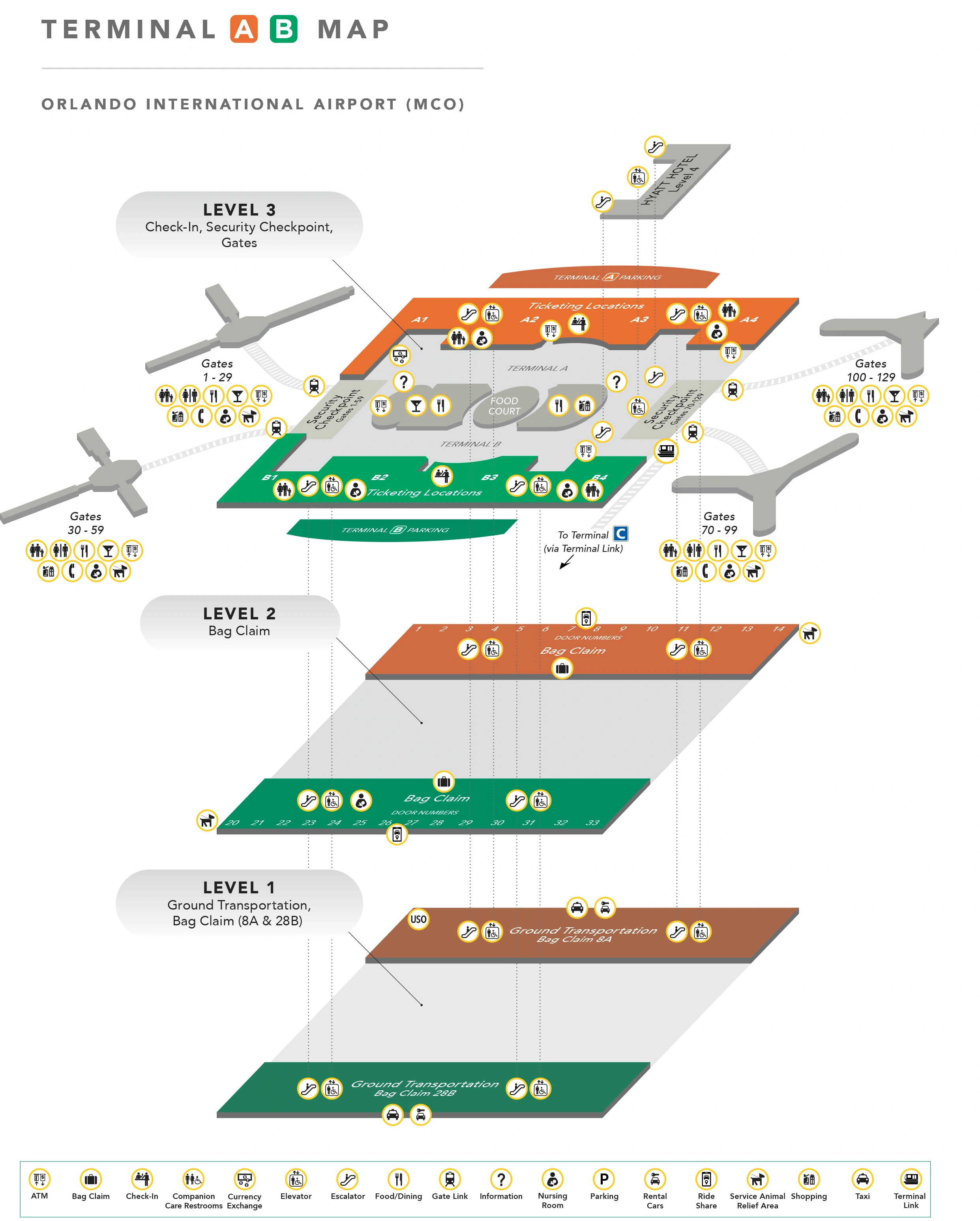
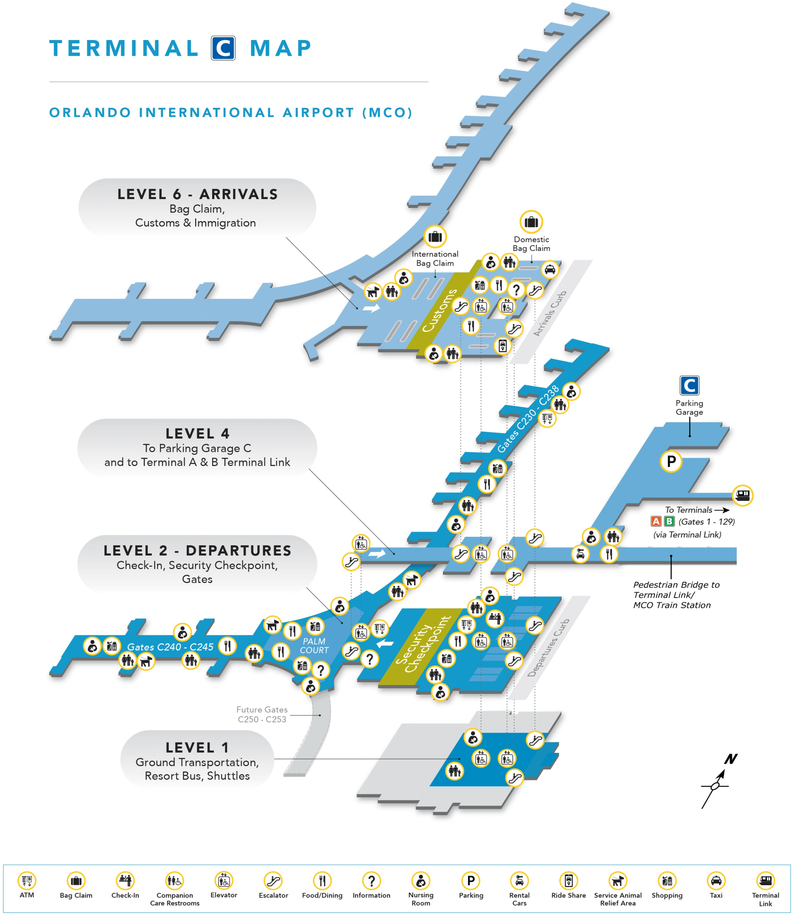
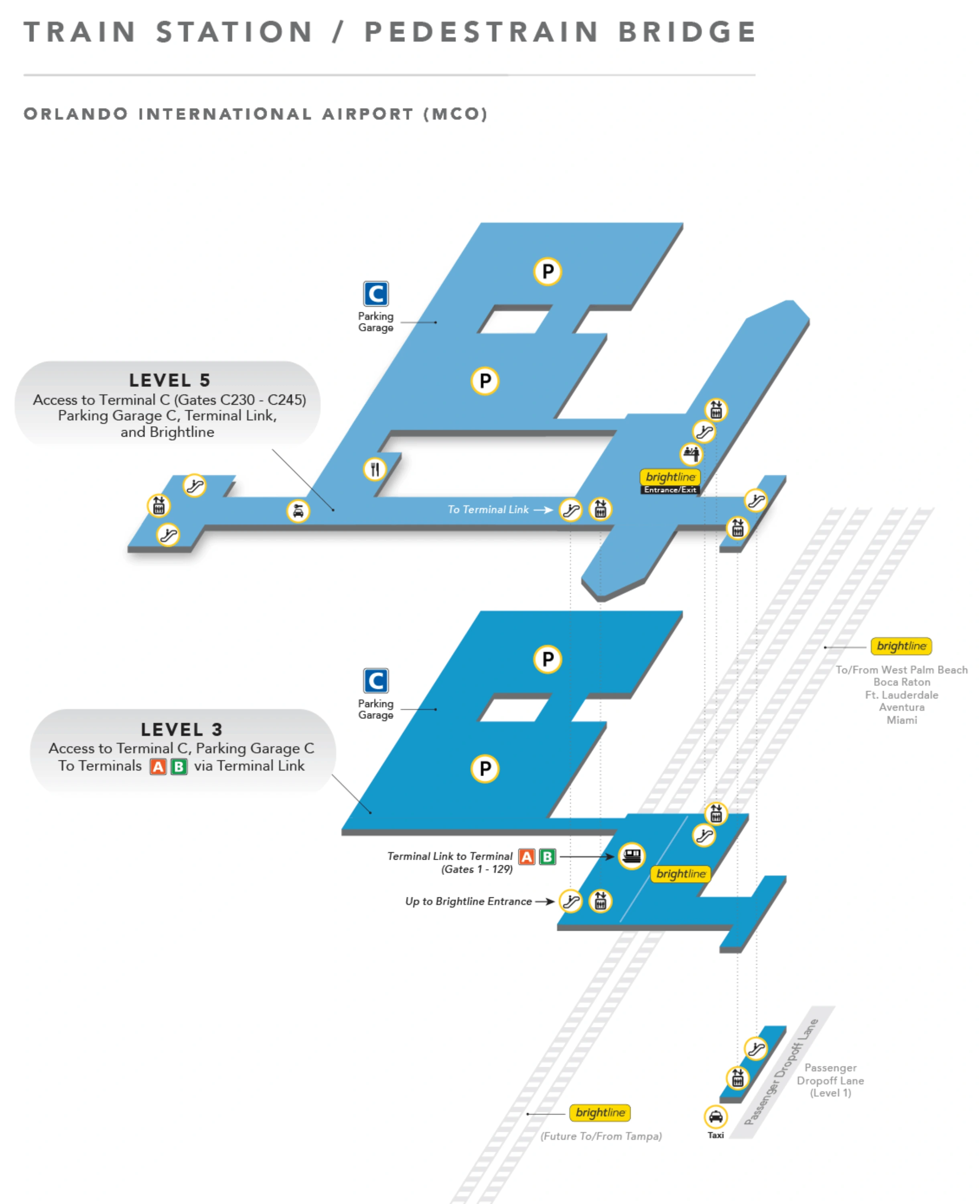
Orlando International Airport (MCO) runs as a split-layout campus: the North Terminal Complex (Terminals A/B) is a central “main terminal” feeding four separated gate satellites, while the South Terminal (Terminal C) is a long, linear pier—both within Orlando’s main airport complex. The whole site is oriented around a north–south roadway loop, with the Train Station/Intermodal Facility sitting between the complexes and acting as the key connector for Terminal Link, parking, and rail.
Map Table
| Terminal | Key Airlines | Primary Function | Transfer Mode |
|---|---|---|---|
| Terminal A | legacy complex carriers | main terminal processing; access to Airside gates | Gate Link APM; bus bridge contingency |
| Terminal B | legacy complex carriers | main terminal processing; access to Airside gates | Gate Link APM; bus bridge contingency |
| Terminal C | mixed domestic + international | linear pier gates; single TSA hub (Palm Court) | walk pier; Terminal Link via ITF |
Orlando International Airport Map Strategy
- Budget time by terminal logic: A/B is short-walk + mechanical dependence; C is long-walk + low mechanical dependence, so your “minutes to gate” math must change by complex.
- Treat A/B people-movers as a single point of failure: know the bus-bridge diversion path (levels, descent points, staging) so you don’t get trapped in the Level 3 queue spillback.
- Prevent wrong-terminal mistakes on the A/B↔C transfer: plan for Train Station drop-off plus the ~1,200-foot gap walk to Terminal C, and assume you may need to re-orient by level on arrival.
- Win ground-transportation at Terminal C by staying on Level 6 for pickups and dropping to Level 4 for the garage bridge; use zone-labeled curbs and level-specific routes to avoid curbside chaos.
2026 Orlando International Airport Terminal Map + Printable PDF
In 2026, MCO’s map-critical reality is the A/B Gate Link Replacement Project (Dec 2025–Fall 2027) reducing people-mover redundancy and increasing outage risk—meaning “normal” A/B access can flip into a bus-bridge operation with major time penalties. Terminal C remains walk-forward (no internal train to gates) with long post-security distances, and the ITF pedestrian bridge connection continues to define the A/B↔C transfer.
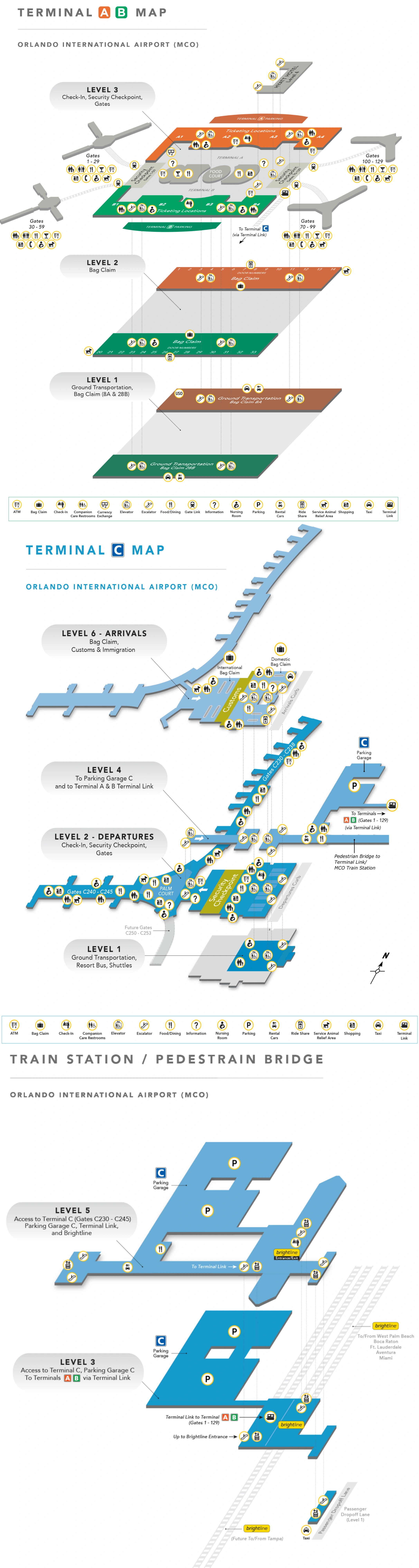
Orlando International Airport Terminal A B Map 2025
Orlando International Airport Terminal C Map 2025
Orlando International Airport Terminal Train Platform Map 2025
2026 Orlando International Airport Map Guide
What is the exact walking distance from Terminal A/B security to the closest Terminal Link / people-mover platform that connects toward the concourses (when it’s operating)?
Walking is about 50 to 150 feet from the end of the security recomposure area to the people-mover platform doors in Terminals A/B (Level 3), which is roughly 10 to 35 seconds at a normal pace.
Both the West and East security checkpoints feed directly into a short post-screening buffer with FIDS/restrooms, and the Gate Link APM station entrances for the Airsides sit immediately adjacent to that buffer. The operational risk isn’t the walk—it’s the lack of queue space: if trams delay, the line backs up into recomposure and can choke the security exit flow.
When the A/B people-movers are down, what is the exact pedestrian route (map path) and total walking distance from Terminal A security to the nearest Gate-area entrance on that concourse?
No pedestrian route exists from Terminal A/B’s main terminal to any Airside gate area when the people-movers are down, because active taxiways physically separate the buildings and walking access is prohibited.
The only contingency is the bus-bridge (“COBUS”) operation: from post-security on Level 3 you’re diverted away from the APM doors, descend to Level 1 via emergency stairs/service elevators, exit to the secure ramp, board an apron/shuttle bus, dock at an Airside ground-level entry (Level 1), then ascend to Level 2 (gate level). The passenger walking portion totals about 550–600 feet end-to-end, but the overall transfer typically adds 15–30 minutes due to vertical transitions, boarding holds, and ramp driving.
What is the exact walking distance from Terminal C security to the farthest gate on Concourse C (end-of-concourse distance)?
Walking is approximately 1,525 feet from Terminal C security (Palm Court zero point) to the farthest gate, C245, which is about 5.8 minutes at an uninterrupted 3 mph pace.
After clearing the single TSA checkpoint on Level 2, you emerge into Palm Court, then continue down the long linear pier toward the C240–C245 wing. Moving walkways help in sections but are not continuous, so real-world pacing with bags and crowds commonly stretches the traverse to 10–12 minutes. The farthest-gate landmark is the gate threshold itself at C245 at the end of the main pier run.
What is the shortest mapped walking route from Terminal C baggage claim to the rental car center tunnel entrance, including the specific level transition points (stairs/escalator/elevator locations)?
No tunnel route exists from Terminal C baggage claim to rental cars; the shortest path uses the Level 4 enclosed pedestrian bridge into Parking Garage C, then drops to Level 2 for rental counters and pickup.
| Step | Level | Adjacent anchor point | Route |
|---|---|---|---|
| Start | 6 | baggage claim carousels | exit the carousel field toward the central vertical core |
| Down | 6 → 4 | main elevator/escalator bank serving baggage claim | descend to Level 4 (do not continue down to Ground Transportation) |
| Bridge entry | 4 | signed “Parking Garage C / Pedestrian Bridge” portal | enter the enclosed bridge connector |
| Cross | 4 | moving-walkway bridge span | walk across into Garage C (ITF/garage side) |
| Final descent | Garage C 4 → 2 | garage elevator core nearest bridge arrival | take elevator down to Level 2 for rental car counters and pickup area |
Where is the exact rideshare pickup zone for Terminal C (precise level/curb/zone on the map), and what is the walking distance from Terminal C baggage claim to that pickup point?
Rideshare pickup for Terminal C is on Level 6 at the Arrivals curb, using the numbered curbside zones on that top-level roadway, and the walk from baggage claim to the curb is about 50 to 100 feet.
Exit the baggage claim carousel area on Level 6 toward the sliding glass doors that open directly to the curb. The pickup friction is traffic, not distance: Level 6 carries both private pickups and rideshare activity, so the curb can gridlock and drivers may circulate between zone numbers. Going down to Level 1 will put you in bus-only ground transportation instead of rideshare.
From Terminal B ticketing, what is the exact mapped route to the Terminal C connection (via garage/train-station connector), and what is the total walking distance end-to-end?
Walking is about 1,400 feet total from Terminal B ticketing to Terminal C’s main building, plus the Terminal Link train ride in between.
From Terminal B ticketing on Level 3, walk about 200 feet to the Terminal Link station in the main atrium’s southeast corner near the Hyatt Regency/fountain area, then ride the Terminal Link APM to the Intermodal Terminal Facility (Train Station). After exiting the platform at the ITF, continue on Level 4 via the pedestrian bridge/walkway connection toward Terminal C—this “gap walk” is about 1,200 feet—then enter Terminal C at Level 4 and descend to Level 2 for check-in/security as needed.
Where is the exact shuttle/bus pickup location on the map for off-airport shuttles (cruise/hotel/charter-style), and what is the walking distance from Terminal A baggage claim to that pickup zone?
Off-airport shuttles pick up at Terminal A, Level 1 (Ground Transportation), in the Commercial Lane bays—typically Spaces A11–A21 for rental/hotel/cruise-style operators—and the walk from a central Terminal A carousel to that zone is about 300 to 450 feet after you go down one level.
Use an elevator or escalator from Terminal A baggage claim (Level 2) to Level 1, then exit the glass doors to the Commercial Curb. Bays A11–A13 are commonly used for off-airport rental car shuttles, A14–A15 for out-of-town/charter-style shuttles, and A19–A21 for many hotel shuttles. Waiting on Level 2 (Arrivals) is the failure mode: those shuttles do not load from the Level 2 inner curb.
What is the exact mapped driving path from the rental car center exit to the main outbound airport roadway, and where are the merge choke points that create the “tunnel delay” risk?
Driving exits from the rental car garages feed into the Terminal Access Road loop, run through the under-terminal tunnel, then hit a post-tunnel “mixing bowl” where multiple traffic streams merge and split—creating the tunnel-delay risk when queues back up.
From the rental car center exit lanes (Garage A/B return/exit), merge onto the Terminal Access Road (loop). Continue toward and through the roadway segment that passes under the Main Terminal building (the tunnel). Immediately after the tunnel, the roadway geometry forces merges with terminal pickup traffic and shuttle/bus movements, and traffic bound for the South Exit (SR-417 / Terminal C–Brightline access via Jeff Fuqua Blvd) funnels toward a signalized intersection at Jeff Fuqua Blvd and the Terminal C/Brightline access road. That traffic signal is the primary choke point that can stack queues back through the post-tunnel merge area.
What is the exact mapped path from Terminal A arrivals curb to the nearest elevator bank that leads to the rental car tunnel level, and what is the walking distance from curb to tunnel entry?
Walking is about 180 to 290 feet from the Terminal A arrivals curb to the rental car tunnel entrance if you go inside and down to Level 1 via the elevator banks between the carousels.
From the Terminal A arrivals curb (Level 2), enter the terminal through the automatic glass doors into the baggage claim hall, then walk to the elevator banks located between the baggage carousels—use the banks near Carousel 6 or Carousel 13 on the A-side as the key landmark. Take the elevator down to Level 1 (Ground Transportation / Rental Car Counters), pass the rental counters, and continue to the tunnel entrance on the same level. The critical wrong turn is crossing the street into the garage on Level 2, which puts you onto parking levels instead of the rental counter/tunnel path.
Where (map-precise) are the closest restrooms and seating clusters to Terminal C baggage claim carousels, and what is the walking distance from the carousel area to those amenities?
Restrooms are on the perimeter walls of Terminal C’s Level 6 baggage claim hall about 50 to 100 feet from the carousel field, while the main seating clusters are outside the baggage hall in the Level 6 meeter/greeter area about 100 to 200 feet from the carousels.
Restrooms sit along the outer walls that ring the carousel area, so the shortest path is a straight walk from the carousel centerline to the nearest wall-side restroom door. Seating is sparse at the belts; for reliable benches, head to the glass exit line of the baggage hall and continue into the public meeter/greeter hall immediately beyond those doors on Level 6.
What is the exact mapped route from the Terminal C parking garage pedestrian entry to the Terminal Link / people-mover access, and what is the walking distance from garage entry to platform?
Walking is about 200 to 300 feet from the west-end pedestrian entry of Parking Garage C to the Terminal Link APM platform inside the Intermodal Terminal Facility (Train Station).
From Garage C, head toward the side of the structure facing the Train Station/ITF (the west end), enter the fused garage–ITF connector, then navigate up to the Terminal Link station level (Level 4 in the ITF). The key landmark is the ITF circulation core immediately adjacent to the Terminal Link entrance doors, with the platform just beyond the fare-gate/entry threshold. This is the “reverse commute” path used when you park in Garage C but ride Terminal Link back to Terminals A/B.
From the Terminal A/B main terminal, what is the exact mapped route to the Brightline station area, and what is the total walking distance (including any connector transitions)?
Walking is about 500 to 700 feet total from the Terminal A/B main terminal to the Brightline station area, plus the Terminal Link train ride to the Intermodal Terminal Facility in between.
Start in the Terminal A/B main atrium on Level 3 and walk toward the Terminal Link station in the southeast corner near the Hyatt Regency/fountain area, then board the Terminal Link APM marked for Terminal C / Train Station (not the Gate Link trams to Airsides 1–4). After arriving at the ITF, exit the platform and follow Brightline signage to the ticketing/security lobby within the same building, generally a short 200–300 foot walk from the APM exit doors.