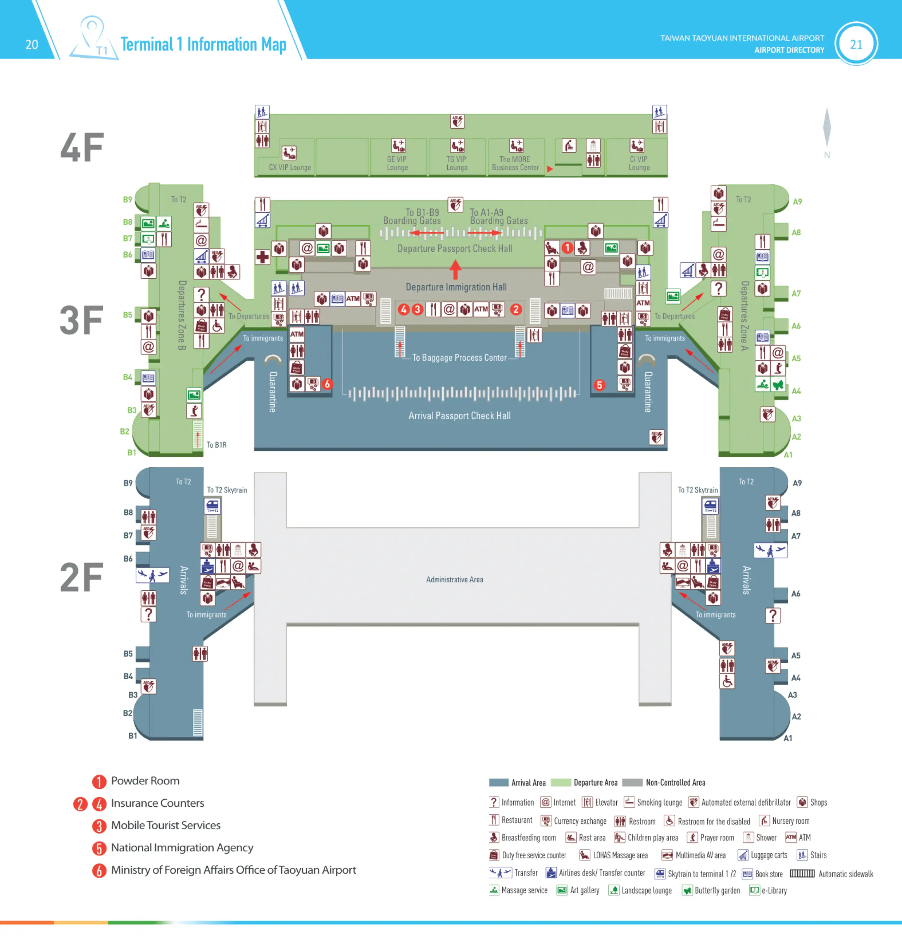
Taiwan Taoyuan International Airport Terminal 1 Map (Most Up-To-Date)
Taiwan Taoyuan International Airport Terminal 1 (TPE T1) is a compact central processing block with two long linear concourses extending out (Concourse A to the north, Concourse B to the south). Most “where do I go next?” confusion comes from vertical stacking: arrivals/check-in on 1F, arrivals corridor on 2F, departures/security on 3F, and transport down on B1/B2. Within Taipei’s main international airport hub, connector entrances are functional but visually tucked away.
Map Table
| Zone | Connection | Walk Time |
|---|---|---|
| 1F Arrivals Hall | Bus / Food Court / 7-Eleven via B1 | 3–5 min |
| 1F South side (Post Office) | Landside Skytrain to T2 (pre-security) | 5 min from arrivals doors |
| 2F near Gate A7 / B6 | Airside Skytrain to T2 (secure) | 5–10 min from most gates |
| Concourse A (A1–A9) | Airside walkway to T2 Concourse D | 10–15 min (A9 ↔ D1) |
Taiwan Taoyuan International Airport Terminal 1 Map Strategy
- Anchor your Terminal 1 → Terminal 2 plan around the correct connector entrance: landside Skytrain by the 1F Post Office, airside Skytrain on 2F near Gate A7 (north line) or Gate B6 (south line), with the airside walkway as the no-wait backup.
- Treat B1 as a landside transport-only layer: buses and food court live here, but B1 cannot solve an airside transfer and can trigger a re-clear security time sink if you drop landside unintentionally.
- Budget extra time for the single 3F security chokepoint: there’s no alternate checkpoint in T1, and queue spillback can reach the circulation area during morning/evening peaks.
- Plan “after-hours survival” and “after-customs routing” with fixed anchors: Gate A7 vending machines for overnight airside food, B1 bus counters/bays by the food court, and curbside pickups aligned to pillar meeting points (Uber) versus the dedicated taxi queue area.
2026 Taiwan Taoyuan International Airport Terminal 1 Map + Printable PDF
Terminal 1’s core layout stays consistent in 2026: landside transport concentrates on B1/B2, while departures funnel to a single centralized security/immigration interface on 3F. Inter-terminal transfers remain split by “public vs secure” Skytrain platforms, and late-night planning still matters because most airside dining and retail winds down before midnight, pushing travelers toward the Gate A7 vending cluster or a deliberate move to Terminal 2.
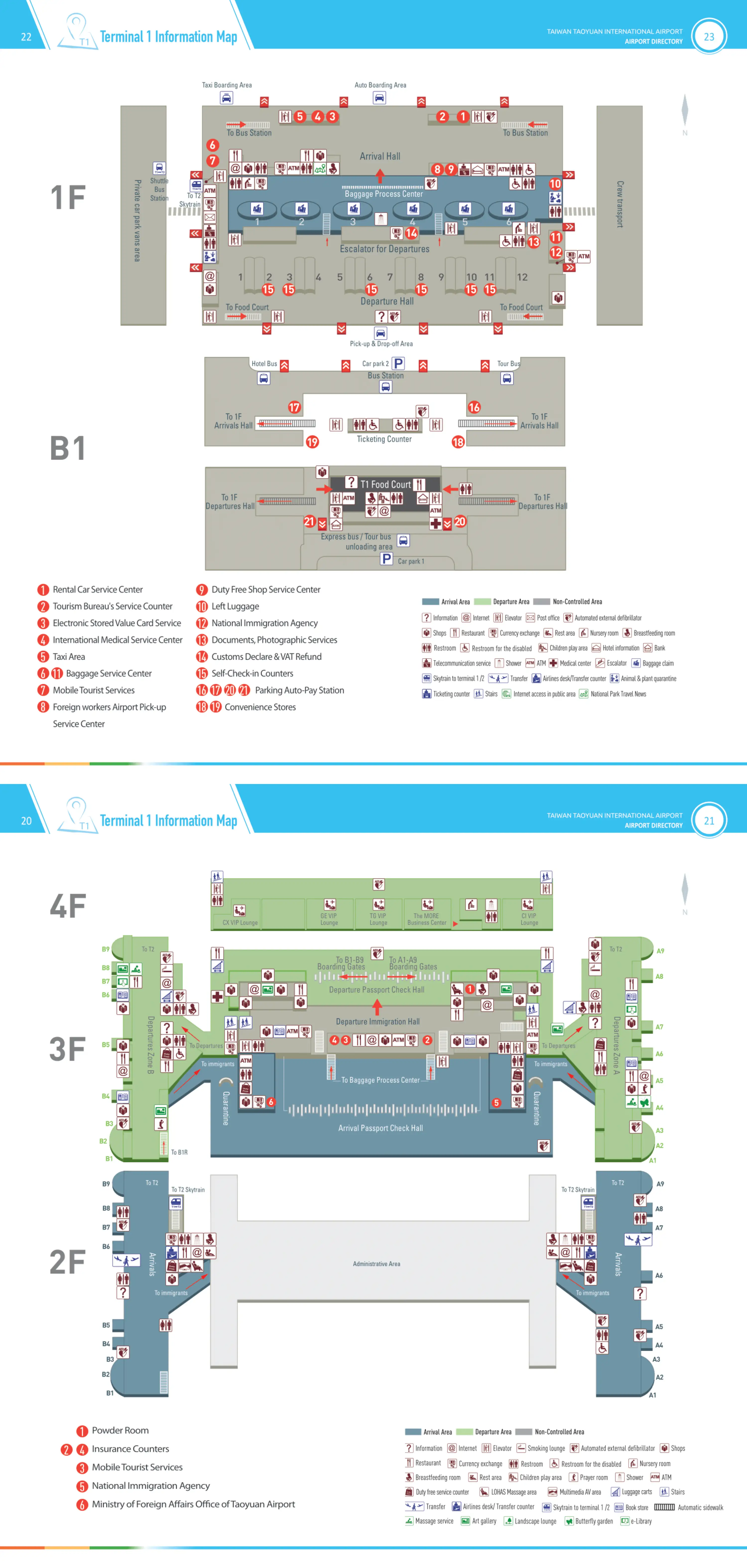
Taiwan Taoyuan International Airport Terminal 1 Level B1 1 Map 2026
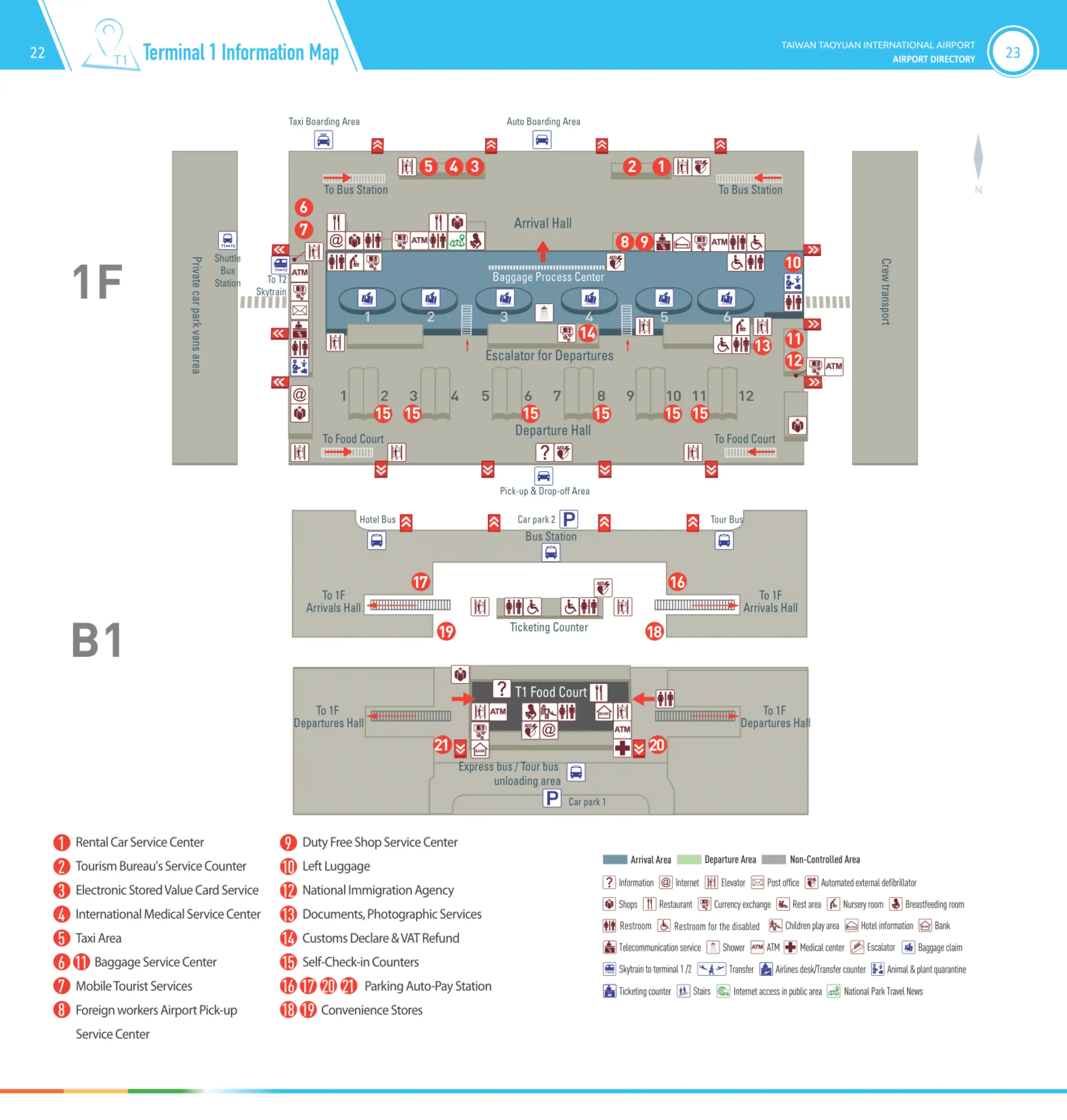
Taiwan Taoyuan International Airport Terminal 1 Level 2 3 4 Map 2026
2026 Taiwan Taoyuan International Airport Terminal 1 Map Guide
What is the exact walking distance (meters) from Terminal 1 Arrivals exit to the Terminal-Transfer (T1→T2) skytrain/people-mover entrance?
Walking distance is approximately 130–160 meters from the Terminal 1 Arrivals customs exit doors (1F) to the landside “Skytrain to Terminal 2” access node. The route runs along the 1F public arrivals hall toward the south side Post Office landmark, where the transfer signage and entry corridor appear.
The walk starts at the 1F customs exit into the arrivals greeting area, continues past the central hall traffic, and ends at the 1F corridor beside the Post Office where “Skytrain / Terminal Transfer” signs cluster before you ascend to the platform. Distance varies by which customs exit stream you use (north vs south doors) and how far into the hall you emerge.
Where is the Terminal 1 → Terminal 2 connector access point relative to fixed landmarks in T1 (e.g., post office)?
The Terminal 1 → Terminal 2 landside connector access point sits on 1F on the south side of the hall beside the Post Office. The entrance presents as a signed corridor for “Skytrain / Terminal Transfer” tucked between the check-in side circulation and the public hall flow.
From the 1F arrivals greeting area, walk south along the interior edge of the hall until the Post Office comes into view; the Skytrain/Terminal Transfer signage and access corridor cluster immediately adjacent. From the 1F check-in area, angle toward the same south-side Post Office zone rather than heading down to B1, because B1 is a landside transport layer that won’t connect you to the secure transfer system.
What is the exact walking distance from Terminal 1 check-in row to the primary security screening entrance during departures?
Walking distance is approximately 200–250 meters from a typical Terminal 1 check-in row on 1F to the primary security screening entrance on 3F. The distance is driven by a short horizontal traverse in the departures hall plus a mandatory vertical move up to the departures core where the centralized checkpoint sits.
Most routes run from the check-in island area to a central escalator bank (about ~150 meters from far check-in positions), then from the top of the escalator on 3F to the security portals (about ~50 meters). The key landmark is the 3F centralized processing interface: once you reach the top of the main escalators, the security entry is the single obvious funnel—there isn’t an alternate checkpoint in Terminal 1.
Where is the main bag-drop queue start point for Terminal 1’s busiest airlines (identify the exact check-in island/counter range on the map)?
The main bag-drop queue for Terminal 1’s busiest carriers typically forms at the front edge of the assigned 1F check-in islands, most often in the Rows 1–10 range for China Airlines’ Terminal 1 operations. Cathay Pacific’s bag-drop/check-in operation anchors at Counter/Island 4 in Terminal 1.
Queueing usually starts in the public 1F departures hall space directly in front of the counter islands, spilling into the main circulation lane that runs parallel to the counters. The fixed landmark cue is the numbered check-in row signage above each island; when queues surge, they extend outward into the central hall rather than sideways along the counters, so the “start” is effectively the first stanchions placed at the hall-facing edge of the relevant row/island.
Which exact gate zones in Terminal 1 physically connect toward Terminal 2 (e.g., T1 B ↔ T2 C), and what is the walking time between the nearest gates?
Terminal 1 Concourse A connects directly into Terminal 2 Concourse D, and Terminal 1 Concourse B connects directly into Terminal 2 Concourse C. The fastest “no-wait” transfer is usually the enclosed airside corridor with moving walkways, not the Skytrain, when minutes matter.
| Airside connection | Nearest-gate example | Typical walk time |
|---|---|---|
| T1 Concourse A ↔ T2 Concourse D | T1 Gate A9 ↔ T2 Gate D1 | 12–15 min |
| T1 Concourse B ↔ T2 Concourse C | T1 Gate B9 ↔ T2 Gate C1 | 12–15 min |
| T1 Concourse A ↔ T2 Concourse D (Skytrain access anchor) | T1 near Gate A7 ↔ T2 near Gate D5 | 5–10 min walk to platform + 2 min ride |
| T1 Concourse B ↔ T2 Concourse C (Skytrain access anchor) | T1 near Gate B6 ↔ T2 near Gate C6 | 5–10 min walk to platform + 2 min ride |
Where is the transfer-security checkpoint located for passengers moving between T1 and T2 airside (exact corridor/level + nearest gate/zone)?
Transfer screening is concentrated at the transfer counters interface where the 2F arrivals sterile corridor feeds up toward the 3F departures holding area, not in the inter-terminal walkway itself. The practical anchor is the Transfer Counters A & B area for Terminal 1, positioned at the root of the concourses where arriving passengers are routed into the transfer process before entering the 3F departure airside zone.
For navigation, treat it as a vertical decision point: arriving flows move along 2F and then route through the transfer/security control to access the 3F departure concourses. The nearest “map-able” zones called out in the audit are the airside Skytrain nodes on 2F near Gate A7 (north line) and Gate B6 (south line)—those nodes sit on the same 2F arrivals-corridor layer where the transfer-controlled paths are enforced.
From Terminal 1 customs exit, what is the exact path to the bus ticket counters/kiosks (include decision points + distance)?
The bus ticket counters are on B1 directly below the 1F Arrivals Hall, reached by descending from the arrivals greeting level rather than going outside to the curb. Distance is approximately 80–120 meters from the customs exit doors to the correct escalator bank, plus one-level descent.
Exit customs into the 1F Arrivals Hall and stay inside the building in the main public hall. Follow “Bus / Bus Station” signs toward the south/west end escalators marked for B1 and descend. At the bottom on B1, the ticket counters present immediately in the open hall zone adjacent to the B1 food court, before the bus bays loop outside that same level. The critical decision point is ignoring the 1F curbside doors (taxis/pickups) and committing to the B1 descent.
From Terminal 1 customs exit, where is the bus bay / boarding curb located (distance + which side of the hall)?
The bus bays are on B1 (Basement 1), immediately beyond the B1 ticketing area, arranged along the terminal frontage in a loop that functions as the boarding curb. Expect roughly 100–150 meters from the 1F customs exit to the bus-bay access once you include the walk to the escalator and the one-level descent.
Exit customs to the 1F Arrivals Hall, follow “Bus / B1” signage to the escalators (typically toward the south/west end), and descend to B1. On B1, the counters sit in the open hall by the B1 food court; the boarding curb is reached by continuing forward from that same concourse toward the exterior-facing edge of B1 where the bays line up. If you find yourself outside on 1F at the taxi/ride-hail curb, you’re on the wrong level for buses.
Where is the ride-hailing (Uber/taxi) pickup point closest to Terminal 1, and what is the walking distance from the arrivals doors?
Ride-hailing pickup is on the Terminal 1 Arrivals curb (1F) using designated pillar meeting points (15, 17, 20, 23), typically 50–100 meters from the arrivals exit doors depending on which door stream you exit. Taxis use a separate managed queue zone rather than the pillar-based pickup.
After you exit customs into the 1F Arrivals Hall, go through the curbside doors to the exterior lanes and align yourself to the pillar number specified in your app (15/17/20/23). The operational constraint is enforcement: vehicles can’t wait at the curb, so being at the correct pillar before the driver arrives matters more than choosing the “closest” door. For standard yellow taxis, head to the dedicated taxi queue area (often signed near the arrivals frontage) rather than waiting at a pillar.
What is the exact walking distance from Terminal 1 departures hall to the Airport MRT station entrance (B1 access)?
Walking distance is approximately 300 meters from the Terminal 1 departures core to the Airport MRT access, driven by multiple vertical transitions down to the rail level. The reliable anchor is that the MRT approach runs through B1 past the food court, then continues down to B2 for the station entry.
From 3F departures, descend to B1 via the central escalator/elevator banks, then walk along the B1 corridor that skirts the B1 food court toward the signed “MRT / Metro” access. Continue down the next escalator/elevator set to B2 for the A12 Airport Terminal 1 Station entrance. The “exact” number varies by where you start on 3F and which descent bank you use, but the map-true path is always 3F → B1 corridor by food court → B2 station entry.
What is the shortest indoor route from Terminal 1 security to the nearest late-night food option (include floor + corridor/zone)?
Yo-Kai Express-style hot-food vending machines near Gate A7 on 3F airside are the most dependable late-night food option inside Terminal 1. The route runs from the post-security central corridor into Concourse A and ends at the Gate A7 zone by the e-library/vending cluster.
After clearing security/immigration into the 3F sterile area, stay on 3F and turn toward Concourse A (the A-gates direction). Walk forward along the airside corridor until you reach the Gate A7 pocket where vending machines cluster; this is the “after midnight” anchor when most restaurants and duty-free shut around 23:00. If it’s still before typical closures, the closest staffed food is usually in the central 3F corridor near the split toward A/B (e.g., outlets near A6/B5), which can be nearer than walking to A7.
Where is the closest convenience store (e.g., 7-Eleven) from Terminal 1 Departures after security (exact zone + walking time)?
There is no confirmed convenience store (7-Eleven) airside in Terminal 1 to reliably route to after security. The most dependable “grab-and-go” fallback in the sterile zone is the Gate A7 vending machine cluster, which is typically 5–7 minutes’ walk from the post-security 3F central corridor.
If you specifically need a 7-Eleven, the map-reliable option is landside on B1 near the food court, which requires going landside before security and then re-entering the departures process. The decision point is timing: use B1 7-Eleven before screening if you want convenience-store items, or commit airside and treat Gate A7 vending as the late-night substitute.
If a traveler goes from Terminal 1 to a Terminal 2 lounge and returns, what is the exact shortest out-and-back route (including connector entrances) and total walking time?
Airside Skytrain is the shortest repeatable out-and-back route, using the 2F Skytrain nodes near Gate A7 or Gate B6 in Terminal 1 and arriving near Gate D5 or Gate C6 in Terminal 2. Total out-and-back transit time is typically 30–40 minutes when you include walking to platforms and realistic wait time, not counting time spent in the lounge.
| Leg | Route anchor points | Typical time |
|---|---|---|
| T1 → Skytrain | 3F airside core → 2F node near Gate A7 or Gate B6 | 5–10 min |
| Skytrain ride | T1 2F (A7/B6) → T2 2F (near D5/C6) | ~2 min |
| T2 → lounge level | 2F arrival area → 4F lounge deck via central escalators | 5–8 min |
| Return (same) | Lounge → 2F node → Skytrain → T1 node → back to T1 gates | 15–20 min |
Night mode (00:00–05:00) adds uncertainty because service is on-demand via a call button, so the “shortest” route stays the same but the buffer you need increases sharply.
From Terminal 1 arrivals, what is the exact shortest route to Terminal 1 short-term parking / pickup curb, and where are the no-waiting enforcement pinch points?
The shortest route to short-term parking/pickup starts at the 1F Arrivals Hall exit doors and goes directly to the 1F curbside frontage, with short-term parking accessed by continuing into the P1/P2 parking buildings instead of waiting in the active curb lane. The critical pinch point is the arrivals curb itself, where “no waiting” enforcement is strict.
Exit customs into the 1F Arrivals Hall and go straight out to the curb through the nearest curbside doors for immediate pickup. For any wait longer than a brief load, drivers should enter Parking Lot P1 or P2 (signed from the frontage) rather than circling the curb. Enforcement hotspots are the active curb lanes in front of the arrivals doors and the designated ride-hail pillar area, where vehicles that linger are pushed on quickly—drivers may loop or cancel if you aren’t at the meeting point.