Kingsford Smith International Airport Terminal 2 Map (Most Up-To-Date)
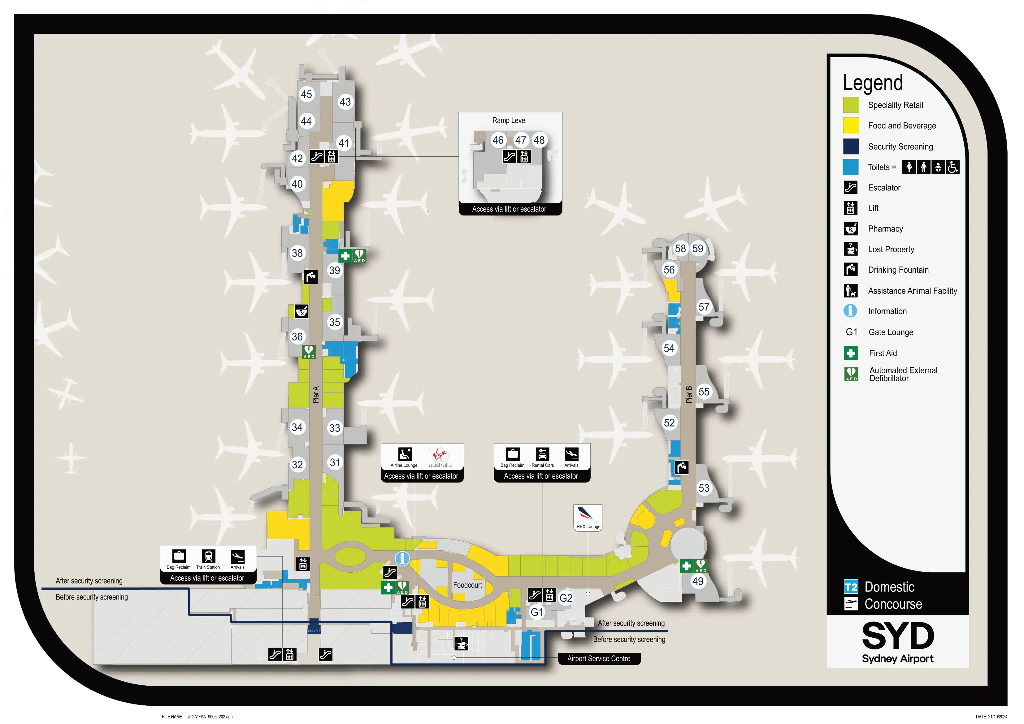
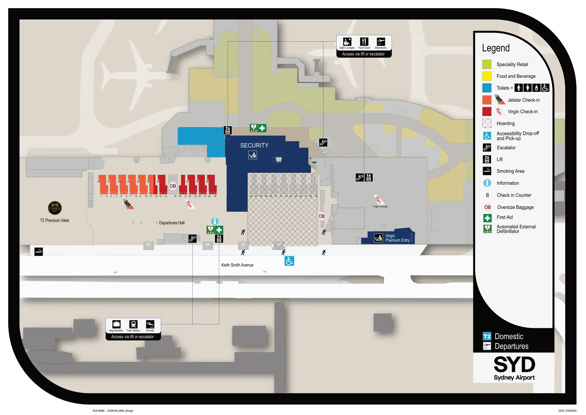
Sydney Airport Terminal 2 (T2) is a rectangular domestic terminal with a central security funnel that feeds a post-screening rotunda, then splits into two long gate piers (a “Y” layout). Landside, check-in stretches east–west with Virgin generally at the T3-connector end and Jetstar toward the far eastern counters. Located within Sydney’s main airport grounds, most time loss comes from the check-in cross-flows, the single security choke point, and the long walk to the pier-tip gates.
Map Table
| Level/Area | Key Zones | Gate Layout | Landside Connections |
|---|---|---|---|
| Departures (upper) | Virgin zone (west) • Jetstar zone (east) • central security | post-security rotunda • Pier A (30s/40s) • Pier B (50s) | curb doors 2–4 • security queue spill zones |
| Airside | duty-free retail maze • main food cluster | Rotunda junction • pier-tip gates 30/31 • 58/59 | no airside terminal transfer |
| Arrivals (ground) | baggage reclaim • greeting hall • exit doors | carousel hall • oversized near Carousel 6 | taxi curb • rideshare/pickup in car park precinct |
| Inter-terminal | T2–T3 pedestrian link | domestic precinct edge | T-Bus to T1 • Airport Link station access |
Kingsford Smith International Airport Terminal 2 Map Strategy
- Start with the right landside sector: Virgin is typically closer to the T2–T3 side, Jetstar typically far east; from the far eastern bag-drop rows, the security funnel is roughly 180–220 m, but cross-traffic from Doors 2–4 can double the time at peaks.
- Security line-finding: the queue tail often forms around the central departures atrium and can spill toward entry doors or drift toward landside cafés; spot the end of the line first, then choose the correct stream (general vs priority) to avoid a full reset.
- Post-security “worst wrong turn”: the rotunda pier split is the penalty junction—Gates 30–49 down one pier and 50–60+ down the other; one wrong branch commonly costs 400–600 m of backtracking.
- Arrivals pickup rule traps: the 15-minute “free/public pickup” is in the domestic car park (about 350–450 m on foot), and rideshare priority pickup is not at the taxi curb; for T1 (International), no walkable connection—use the orange T-Bus stop on the Arrivals curb (west end) or the train.
2026 Kingsford Smith International Airport Terminal 2 Map + Printable PDF
Construction-era conditions still matter for 2026: hoardings and lane reconfigurations can shift the effective “straight path” between check-in, security, and the rotunda. Security throughput can swing sharply depending on how many lanes are online during the CT-scanner upgrade cycle. Treat any “15-minute kerb-to-gate” messaging as best-case only, and plan your route around the single central security funnel and the pier-tip gate walks.
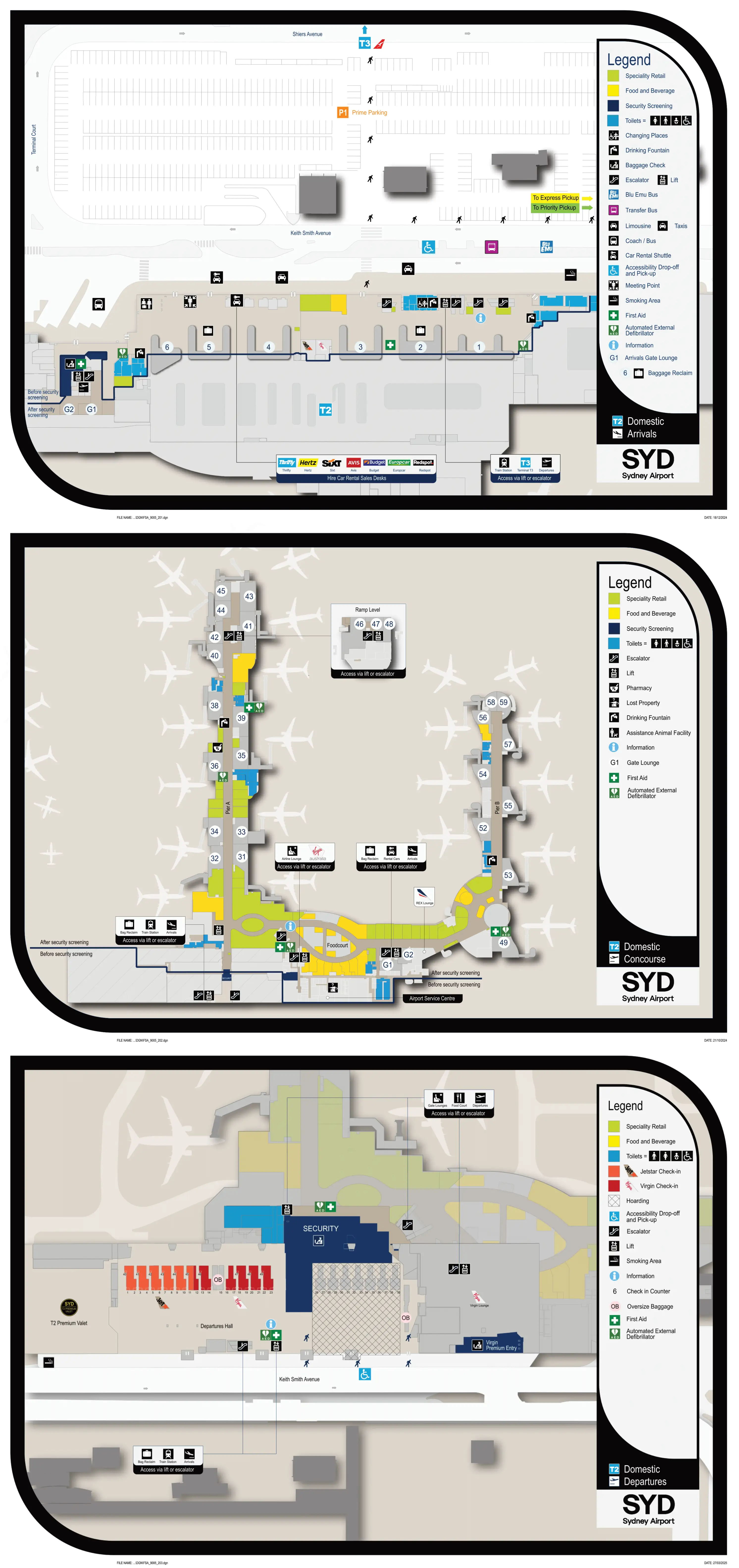
Kingsford Smith International Airport Terminal 2 Domestic Arrivals Map 2025
Kingsford Smith International Airport Terminal 2 Domestic Concourse Map 2025
Kingsford Smith International Airport Terminal 2 Domestic Departures Map 2025
2026 Kingsford Smith International Airport Terminal 2 Map Guide
What is the exact walking distance (meters) from the furthest airline check-in/bag-drop row in Terminal 2 to the main security screening entrance?
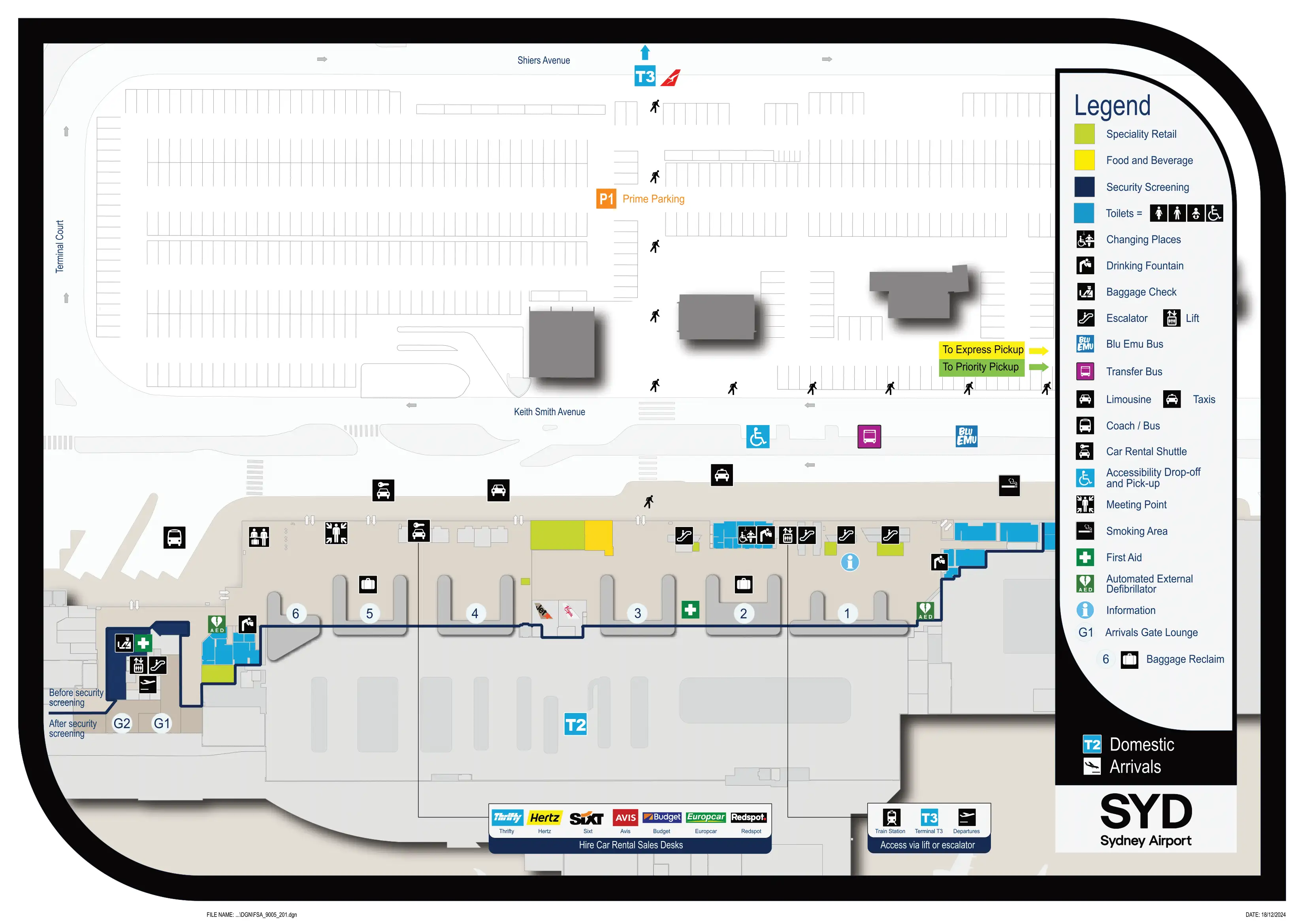
Walking distance runs about 180–220 meters from the furthest Jetstar-side bag-drop/check-in rows at the far eastern end of T2 to the start of the central security screening queue/maze.
Construction hoardings and queue tails can force a less-direct line than the straight “east-to-center” vector, especially when you have to angle around kiosk islands, columns, and other flight queues. The slowest segment is usually the cross-flow zone where you cut across arriving foot traffic from Departures entry Doors 2–4 toward the central security funnel on the northern wall; that’s where a short distance turns into a time penalty.
Where is the start point of the Terminal 2 security queue (the physical queue entrance) relative to the departures hall—i.e., which landmark/zone does the line spill toward first?
The security queue typically starts at the central departures atrium/rotunda area—the main open focal point of the departures hall—then snakes outward as volume rises.
The line most often spills back toward the front-of-house doors first (toward the curbside entry area around Doors 2–4), because there isn’t much “depth” between check-in rows and security for it to extend straight back. When it overflows further, it can drift laterally toward nearby landside café/seating pockets on either side of the central hall, which can make the actual queue tail sit well away from the security entrance signage.
What is the exact walking distance (meters) from Terminal 2 Arrivals exit doors to the Express/free pickup area referenced as about a 5-minute walk?
Walking distance is about 350–450 meters from the main Terminal 2 Arrivals exit doors to the 15-minute free “public pickup” area in the domestic car park precinct.
The route starts at the Arrivals glass exit (after the greeting hall), then immediately crosses the curbside traffic lanes via the marked pedestrian crossings. From there you head into the Domestic Car Park (P2/P3) entrance and continue to the signed public pickup bays (often involving a lift/escalator depending on the level you’re directed to). The key constraint is that this pickup is not at the terminal curb—waiting at the Arrivals roadway is the common mistake that triggers the penalty loop.
Which specific door/bay in Terminal 2 Arrivals is the fastest path to the rideshare pickup (shortest on-foot route)?
No single Arrivals door drops you directly into the rideshare bay, because rideshare pickup is in the domestic car park priority pickup zone rather than on the terminal curb.
- Use the central Arrivals glass exit from the baggage reclaim/greeting hall, then commit immediately to the nearest marked pedestrian crossing over the curbside lanes.
- Follow the green “Priority Pick-up” wayfinding into the Domestic Car Park precinct and continue to the signed rideshare bays.
- Avoid the taxi/rank curb frontage entirely—waiting there is the common wrong move, and rideshare drivers won’t load in the taxi lane.
What is the exact walking distance (meters) from the baggage reclaim carousel area in Terminal 2 to the taxi rank?
Walking distance is about 60–80 meters from the baggage reclaim carousel area to the Terminal 2 taxi rank.
The shortest path runs from the carousel hall into the greeting zone, then straight out through the main Arrivals glass doors to the curb where the taxi coordinator and rank are immediately visible. This is the “prime real estate” option compared with rideshare or free pickup, which both require a longer walk into the car park precinct.
Where exactly is the terminal transfer shuttle/bus stop for Terminal 2 to Terminal 1 (door number / curbside zone / bay identifier as shown on the airport map)?
The Terminal 2 → Terminal 1 shuttle (the orange T-Bus) boards on the Arrivals level curbside, positioned toward the western end of the Terminal 2 roadway (the Virgin-side end), separate from the main taxi rank frontage.
The stop is on the outside roadway immediately in front of Arrivals—follow signage for T-Bus / Terminal Transfer rather than “Taxis” or “Priority Pick-up.” The dealbreaker constraint is that there’s no walkable connection to T1; attempting to walk forces a long, non-pedestrian-friendly landside penalty route, so you must use the shuttle (or the Airport Link train via the station access).
What is the exact walking distance (meters) from Terminal 2 Arrivals to the Terminal 2 to Terminal 3 pedestrian connection (the point where you are in the Terminal 3 precinct)?
Walking distance is about 250–300 meters from the central Terminal 2 Arrivals area to the point where you’re effectively in the Terminal 3 precinct via the T2–T3 pedestrian connection.
The quickest route begins at the main Arrivals exit, then follows the signed path along the external sheltered concourse (or via the station concourse connection) toward Terminal 3. This is a landside transfer: you can walk between T2 and T3, but you typically cannot transfer airside, so expect a security reset if you’re switching terminals for departures.
What is the exact walking distance (meters) from the main security screening exit to the furthest departure gate (highest gate number) in Terminal 2?
Walking distance is about 500–550 meters from the main security exit to the furthest pier-tip gates at the high end of the numbering (typically Gates 58/59).
The path runs security exit → forced retail/duty-free “maze” → central rotunda food hub → correct pier entry at the rotunda split → down the length of the pier to the tip gate. The biggest hidden penalty is committing to the wrong pier at the rotunda: a bad turn can add 400–600 meters of backtracking before you even resume toward Gate 58/59.
Where is the primary post-security food court / main food cluster located relative to the gate piers (which corridor/side do you turn into first after security)?
The main post-security food cluster sits in the central rotunda/atrium hub immediately after you clear the security exit and the mandatory retail/duty-free pass-through, before the concourse splits into the two gate piers.
You don’t commit to a pier first to reach the food court; instead, you flow out of the retail corridor straight into the rotunda where the terminal’s dining is concentrated. From that hub, the two pier corridors branch off—taking one pier toward the 30–40 gates or the other toward the 50–60 gates leaves the main dining cluster behind and creates a round-trip penalty if you backtrack for food.
What is the exact walking distance (meters) from security exit to the nearest coffee/quick-serve outlet (first viable grab-and-go point after screening)?
Walking distance is under 30 meters from the security exit to the nearest coffee/quick-serve outlet just beyond screening.
The first viable grab-and-go point is positioned immediately at the airside egress where the flow dumps you out of screening and into the post-security retail corridor leading toward the rotunda. If the closest outlet’s queue is long, continuing a short distance deeper toward the central rotunda food hub can reduce wait time, but the absolute nearest coffee option is effectively right outside the screening exit.
Which single internal junction (named corridor / fork / escalator bank) is the most common wrong-turn trap between security and the Jetstar/Virgin gate area in Terminal 2 (the point where taking the wrong branch costs the most backtracking distance)?
The Pier A / Pier B split at the central rotunda (post-security food hub) is the highest-penalty wrong-turn junction in Terminal 2. Taking the wrong pier commonly forces a full reset back to the rotunda before you can head to the correct gate range.
After the security exit and retail corridor, the space opens into the rotunda where the concourse forks into two long, similar-looking glass piers. The fastest verification is gate numbering: one branch trends toward the 30–49 range, the other toward the 50–60+ range (including Gate 58/59 at the far tip). If you drift into the wrong branch even 150–200 m, correcting it typically adds roughly 400–600 m of extra walking because you must backtrack to the rotunda fork before continuing.