Kingsford Smith International Airport Terminal 1 Map (Most Up-To-Date)
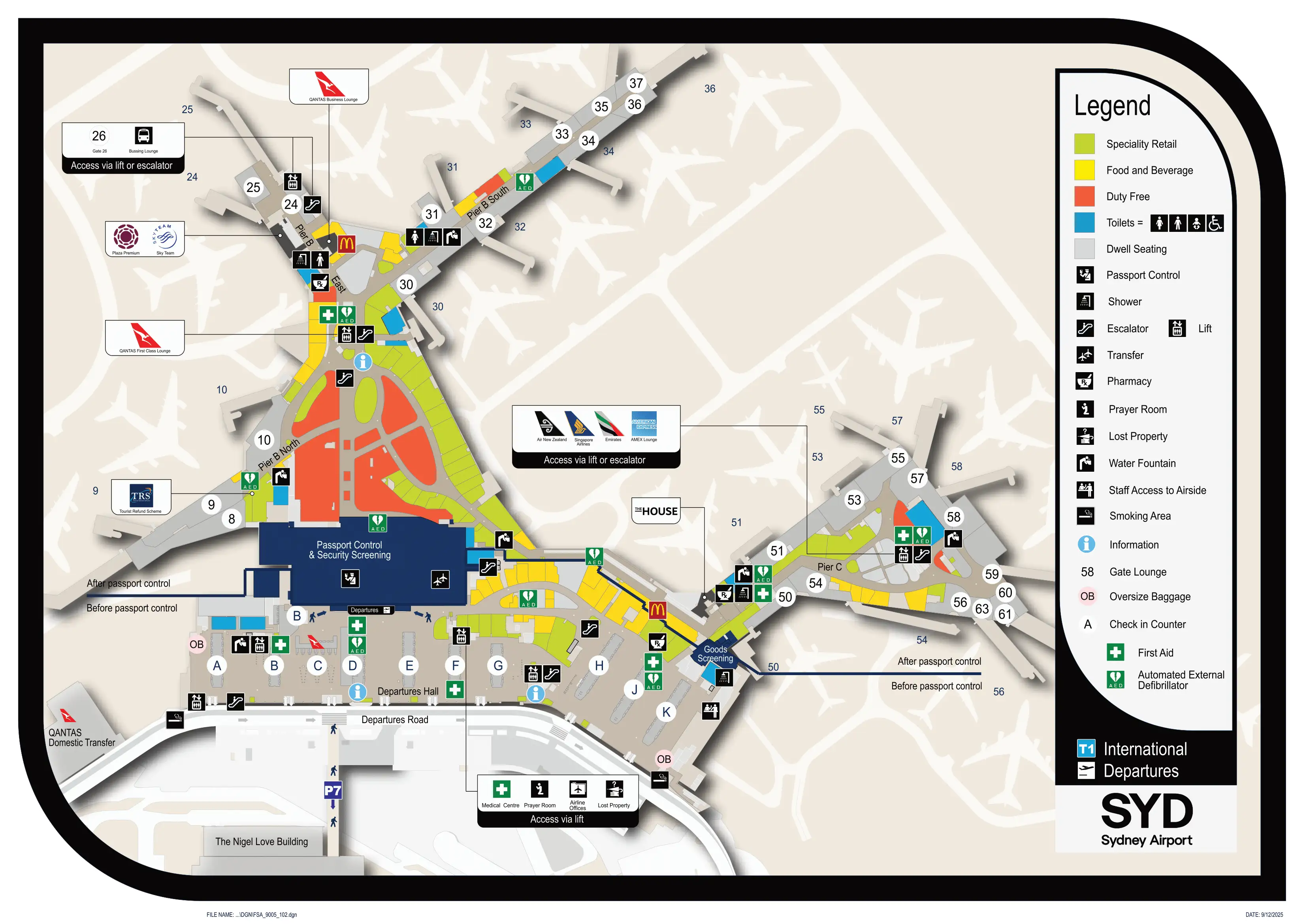
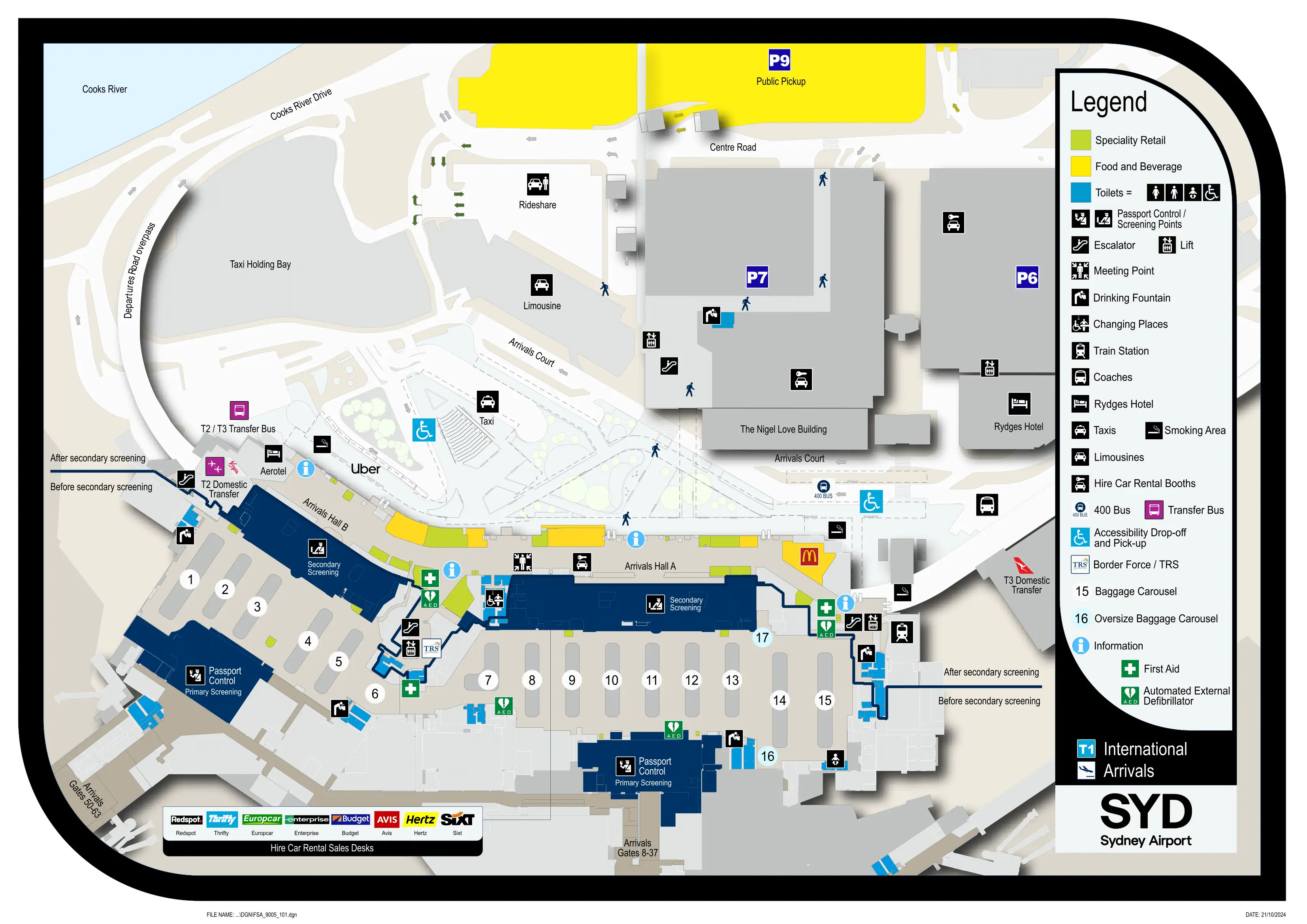
Sydney Airport’s Terminal 1 (International) is a long, two-pier layout feeding into a central processing core, with Pier B (gates 8–37) and the longer Pier C (gates 50–63) stretching away from the arrivals/departures hub. Arrivals and baggage/biosecurity sit on Level 1, while check-in and departures security sit on Level 2. Landside splits into Arrivals Hall A (train bias) and Arrivals Hall B (bus bias) within Sydney’s main airport complex.
Map Table
| Zone | Connection | Walk Time |
|---|---|---|
| Pier C gates 50–63 | Passport Control / Arrivals core | ~10 min / ~800 m |
| Heinemann Duty Free exit | Border queue start, SmartGate split | 0–1 min |
| Baggage Reclaim (carousels 1–14) | Biosecurity screening line, exit doors | ~1 min / 50–80 m |
| Arrivals Hall B curbside | T-Bus (T2/T3 transfer) | ~1 min / 30–50 m |
| A/B interface doors (landside) | P9 Express Pickup | ~5 min / 350–450 m |
| Arrivals Hall A (near McDonald’s / WHSmith) | Airport Link station access, paid gate line | ~1 min / 50–100 m |
Kingsford Smith International Airport Terminal 1 Map Strategy
- Treat Pier C (gates 50–63) as a built-in delay: ~800 m to border processing, plus the Duty Free funnel, so small wrong turns compound into missed queues.
- Use the Duty Free exit as your border “decision node”: commit to SmartGate vs manual immediately; if SmartGate fails, pivot to assistance/manual without drifting across the main inflow.
- Beat the P9 fee trap by timing, not speed: follow yellow “Express Pick Up” signage from the A/B interface and only have the driver enter P9 when you’re at (or steps from) the P9 entry/gantry.
- Don’t assume inter-terminal walkability: T1 to T2/T3 requires a vehicle transfer; aim for Arrivals Hall B for the T-Bus, and use Arrivals Hall A (McDonald’s / WHSmith side) for the Airport Link entry if you’re choosing rail.
2026 Kingsford Smith International Airport Terminal 1 Map + Printable PDF
Terminal 1 remains Sydney’s international processing hub in 2026, with arrivals flow anchored by the Duty Free funnel into the SmartGate/manual split and a single biosecurity exit wall that can stack during the post-curfew morning surge. A printable PDF map is most useful when it highlights the exact “queue start” landmark, the Hall A vs Hall B landside split, and the longer Pier C walking penalties.
Kingsford Smith International Airport Terminal 1 Departures Map 2025
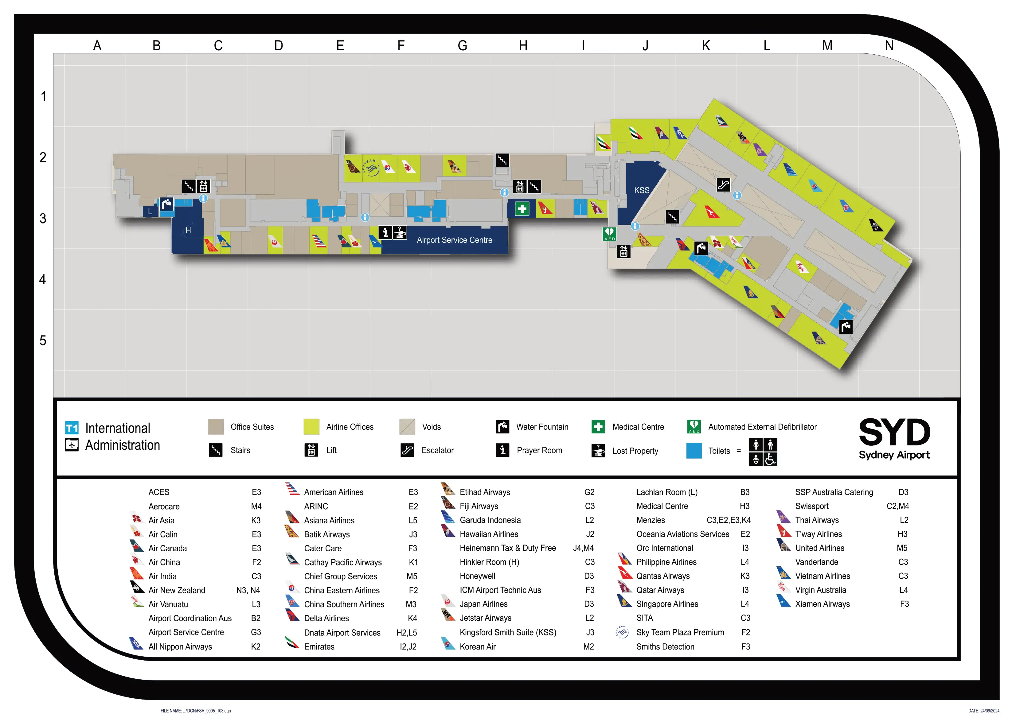
Kingsford Smith International Airport Terminal 1 International Administration Map 2025
Kingsford Smith International Airport Terminal 1 International Arrivals Map 2025
Kingsford Smith International Airport Terminal 1 International Arrivals Mezzanine Map 2025
2026 Kingsford Smith International Airport Terminal 1 Map Guide
What is the exact walking distance (meters) from the furthest international arrival gate to the start of the passport-control queue in Terminal 1 Arrivals?
The walking distance is approximately 800 meters from the furthest Pier C gate cluster (Gates 60–63, typically Gate 63) to the passport-control queue start in Terminal 1 Arrivals.
Pier C’s distal gates feed into a long concourse with intermittent travelators and a connector that drops you into the arrivals processing core before the Duty Free funnel ends at the border decision point. Use the Heinemann Duty Free walkthrough exit on Level 1 as the practical “queue start” anchor: if you’re arriving at Gates 60–63, plan this as a near-kilometer trek before you even see how long the border line is.
Where is the first clearly identifiable “queue start” point for the arrivals border process in Terminal 1 (exact landmark + level)?
The queue start is on Level 1 immediately after you exit the Heinemann Tax & Duty Free walkthrough into the arrivals processing hall.
This is the first fixed decision node where the flow splits into SmartGate kiosks versus manual processing lanes. The landmark to triangulate is the Duty Free exit opening itself: once you clear the retail fixtures and partitions, you hit the first visible line-forming area with directional signage for SmartGate/ePassport holders and the standard passport-control counters. If you don’t see the border lanes yet, you’re still inside the Duty Free funnel.
What is the exact location (level + hall/zone) of the first biosecurity/customs screening checkpoint after baggage reclaim in Terminal 1 Arrivals?
The first biosecurity/customs screening checkpoint is on Level 1 along the eastern exit wall of the Baggage Reclaim Hall, directly between the carousels and the public Arrivals Halls (A and B).
It presents as a continuous barrier line across the terminal-side edge of baggage reclaim, feeding into the two primary channels: “Green” (Nothing to Declare) and “Red” (Declare). Use the carousels as your anchor: once you turn away from the reclaim belts toward the landside doors, the checkpoint is the first controlled line you must pass before you can enter Arrivals Hall A/B.
What is the exact walking distance (meters) from the main baggage reclaim carousel area to the biosecurity/customs exit doors in Terminal 1 Arrivals?
The walking distance is approximately 50 to 80 meters from the central baggage reclaim carousel area (around Carousels 7/8) to the biosecurity/customs exit doors on Level 1.
The path runs straight from the carousel aisles toward the eastern exit wall where the Green/Red channels form the controlled barrier. The key landmark is the biosecurity line itself: even though the doors are visually close, the exit can feel “far” during the morning surge because the Green channel often backs up into the carousel lanes, blocking the most direct aisle routes from Carousels 10–14.
Which specific arrivals exit doors lead most directly to the Express Pickup route (door label/letter/number as shown on the Terminal 1 map)?
The most direct Express Pickup (P9) route starts from the arrivals exit doors at the interface between Arrivals Hall A and Arrivals Hall B.
Those A/B “midpoint” doors put you onto the yellow-signed “Express Pick Up” path without having to traverse the full frontage from either end. Use the landside hall split as your landmark: if you’re exiting next to the Hall A cluster (train side, near McDonald’s/WHSmith), you’re too far north; if you’re fully outside Hall B (T-Bus side), you’ve overshot south—backtrack to the A/B join and follow the yellow (not green) pickup signage toward P9.
What is the exact walking distance (meters) from the Terminal 1 arrivals exit doors to the Express Pickup / P9 pickup bays, including the required road crossings?
The walking distance is approximately 350 to 450 meters from the Terminal 1 arrivals exit doors (best from the A/B interface) to the P9 Express Pickup bays.
The route is a sheltered walk that pushes you away from the curb before it pays off: follow yellow “Express Pick Up” signage through the Arrivals Court area, then cross Centre Road at the signed pedestrian crossing, and enter the P9 car park structure at ground level to reach the bays. If you end up at the paid curbside pickup zones (green “Priority Pickup” cues), you’re on the wrong system and will need to reset back to the yellow-labeled path.
Where is the T-Bus stop at Terminal 1 located relative to Arrival Hall B (exact curbside position as labeled on the map)?
The T-Bus stop is on the Arrivals Level curb directly outside Arrivals Hall B.
It sits on the Hall B frontage near the Hall B “Meeting Point” area and alongside the rideshare/taxi holding activity zone, where the curbside signage clusters for ground transport. The map anchor is Arrivals Hall B itself: once you exit Hall B to the curb, look for the marked transfer signage for domestic connections (T2/T3 transfer), rather than drifting toward Hall A’s train-side retail frontage.
What is the exact walking distance (meters) from the Terminal 1 arrivals exit to the T-Bus stop?
The walking distance is approximately 30 to 50 meters from the Arrivals Hall B exit doors to the T-Bus stop on the curb.
This is essentially “door-to-curb” outside Hall B, with the stop positioned in the immediate ground transport lineup near the Hall B meeting point area. If you exit via Arrivals Hall A instead, the walk becomes a frontage traverse of roughly 200 to 250 meters to reach Hall B’s curbside stop area, which is the common failure mode for transfers.
On which level, and at what mapped landmark, is the main international departures security screening entry located in Terminal 1?
The main departures security entry is on Level 2 (Departures), positioned between Check-in Counter Row J and Row K.
The key landmark is the end-of-hall “funnel” where the linear check-in rows (A through K) compress into a single security injection point. If you check in at Rows A–C, you still need to walk laterally along the departures hall toward the J/K end to find the main screening entry. Use the row lettering overhead as your confirmation—when you reach the J and K counter banks, you’re at the correct security access point.
What is the maximum walking distance (meters) from the departures security exit to the furthest departures gate cluster in Terminal 1?
The maximum walking distance is approximately 800+ meters from the departures security exit (post–Duty Free) to the furthest gate cluster at Pier C (Gates 50–63, typically Gate 63).
After screening you’re routed into the Duty Free maze, then out to the central forum/rotunda where you branch to Pier B or the longer Pier C arm. The landmark to lock onto is the Pier C direction split at the central airside hub: once you commit to Pier C, you’re on the long concourse run. Treat the “10-minute walk” guidance as fragile during peak periods—crowds and retail pinch points can make the same 800 meters feel like 12–15 minutes.
Where does the pedestrian route from Terminal 1 Arrivals connect into the Airport Link train station access path (exact corridor/level transition on the map)?
The pedestrian connection to the Airport Link access path begins on the Arrivals Level at the northern end near Arrivals Hall A, beside the McDonald’s and WHSmith frontage.
From the public arrivals doors, follow the train signage into the station access corridor that pulls you off the curbside frontage and into the station approach. The triangulation anchor is the Hall A retail cluster: if you’re standing near McDonald’s/WHSmith, you’re at the correct end for the station entry; if you’re outside Arrivals Hall B by the T-Bus area, you’re on the wrong end and will need to walk back along the terminal frontage to reach the Hall A-side station corridor.
What is the exact walking distance (meters) from the Terminal 1 arrivals exit to the start of the paid train-station gate line (first queue point)?
The walking distance is approximately 50 to 100 meters from the Arrivals Hall A exit to the start of the paid Airport Link station gate line.
The first queue point forms at the station access gates reached from the Hall A-side approach corridor near the McDonald’s / WHSmith landmark. If you exit from Arrivals Hall B instead, you’re typically looking at roughly 200 to 250 meters of backtracking along the terminal frontage to reach the same station entry and its paid gate line, which is why Hall choice matters for rail.