London Stansted Airport Terminal Map (Most Up-To-Date)
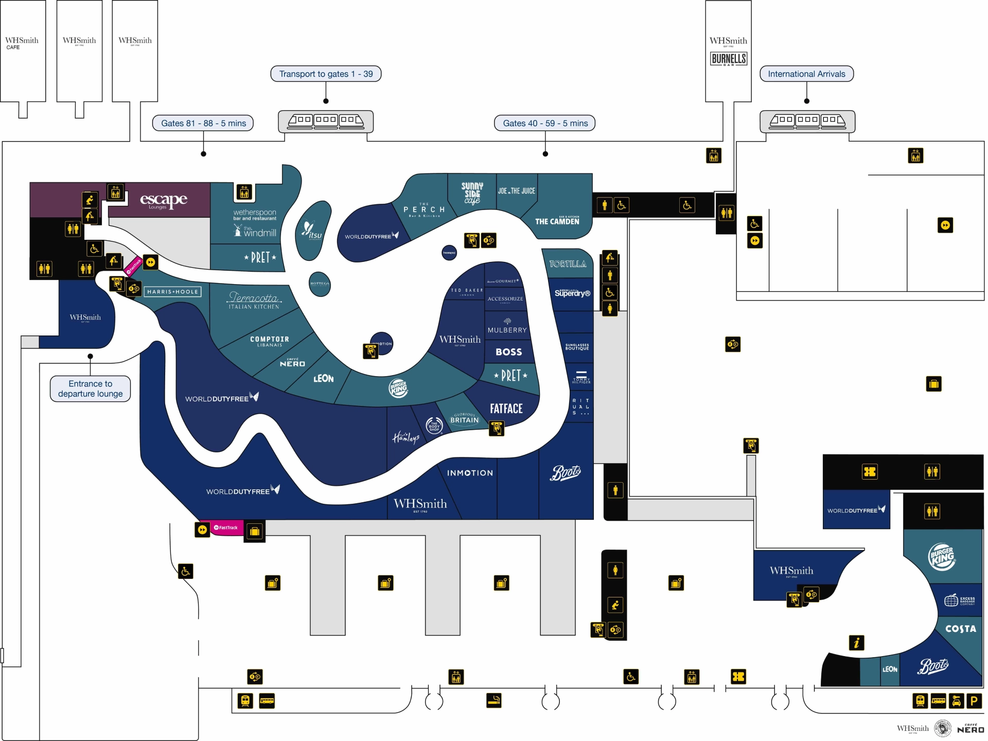
London Stansted’s passenger layout is a single main terminal that feeds three satellite gate buildings plus a downstairs bus-gate zone, all organized around a central airside lounge with long “spokes” outward. Within London’s third-busiest airport grounds, flow runs landside (rail/coach → check-in A–E) into one central Security block, then into an airside core where routes split: train-served Satellites 1–2, a walk-only corridor to Satellite 3, and a tucked-away descent to APV bus gates.
Map Table
| Terminal | Key Airlines | Primary Function | Transfer Mode |
|---|---|---|---|
| Single terminal + Satellites 1–3 | Ryanair | Satellite 3, Gates 40–59 | Walkway only |
| Main terminal airside core | Jet2, TUI | Retail + dining dwell zone | Foot |
| Satellite 1–2 gates | British Airways, Emirates | Gates 1–39, 81–88 | TTS shuttle |
| APV gates under terminal | Mixed LCC overflow | Remote stands, Gates 90–93 | Escalators/lifts + bus |
London Stansted Airport Terminal Map Strategy
- Treat Security as a variable-time choke point, then use the map to spot where queues physically spill back into the check-in hall so you can choose the shortest approach from Zones C/D versus A/E.
- Decide “train vs. walk vs. downstairs bus gates” immediately after Security; the map’s first split-point is the difference between a predictable transfer and a long corridor commitment.
- Leave lounge seating based on distance, not instinct: the map makes the Satellite 3 walk and the APV descent visible so you stop under-budgeting gate travel time.
- Use anchor amenities to stay calm and efficient after screening: map the first toilets, water, and help points so you avoid post-security clumping and gate-area queues.
2026 London Stansted Airport Terminal Map + Printable PDF
Current operations still hinge on a single Security checkpoint feeding a forced World Duty Free walkthrough, which can slow orientation right after screening. Gate access remains split: the TTS serves Gates 1–39 (and Satellite 2 levels), while Gates 40–59 are walk-only and routinely feel farther than expected. Remote-stand departures continue to use the downstairs APV Gates 90–93.
Archive London Stansted Airport Terminal Map
Below are all historical map versions for London Stansted Airport. Each year includes the official map available for that period, presented as both WebP and PDF.

2026 London Stansted Airport Map Guide
What is the exact walking distance from the main Security exit to the furthest common gate cluster (furthest pier end) on the departures map?
Walking distance from the main Security exit to the furthest pier-end gate area is about 1.0–1.2 kilometers to the Satellite 3 end (Gates 50–59, with Gate 59 as the practical “furthest common” point). That typically translates to roughly 15–20 minutes on foot depending on crowding and travelator speed.
The route runs from the Security exit into the World Duty Free walkthrough, across the central Departures Lounge, then past the start of the Gates 40–59 corridor and along the long pedestrian walkway into Satellite 3. Congestion after screening and along the corridor often matters more than raw distance, so treat the map’s “Gates 40–59 walkway entrance” as your go/no-go landmark for timing.
Where is the Fast Track Security entrance located relative to the main Security entrance (exact side/adjacent landmark on the terminal plan)?
Fast Track Security is on the right-hand side of the main Security entrance, beside the assisted-travel access. It sits immediately next to the main bank of security gates rather than being in a separate area.
From the check-in hall approach, aim for the central Security block at the rear of the hall, then keep right as the queue space opens up. The Fast Track entry aligns with the right-biased access point used for wider accessible gates and assistance flows, so the nearby landmark is the assisted/PRM lane area rather than the central general-queue lanes.
What is the walking distance from the bag drop / check-in hall entrance to the start of the Security queueing area (where lines physically form)?
Walking distance from the check-in hall to where the Security lines physically start is typically 50–75 meters from the central check-in zones, and up to about 200 meters from the far ends of the hall. The distance expands when queues backfill into the check-in space and the “queue start” shifts outward.
| Starting point in check-in hall | Walk to Security queue start | Map anchor to aim for |
|---|---|---|
| Zones C/D (central islands) | ~50–75 m | Central rear of hall, Security queue maze entrance |
| Zone A (one end of hall) | ~150–200 m | Lateral walk toward center, then into queue lanes |
| Zone E (opposite end) | ~150–200 m | Lateral walk toward center, then into queue lanes |
Where are the bus gate / remote-stand departure gates located on the map (identify the specific gate range / zone name used for bussing)?
Bus-gate / remote-stand departures are concentrated at Gates 90–93, the APV gate zone underneath the main terminal. This is the map-labeled downstairs area reached by going toward the shuttle train zone, then taking the right-hand escalators/lifts down instead of boarding the train.
The APV Gates 90–93 area is shown as a lower-level gate cluster with a holding/quiet seating zone and bus boarding for remote stands. On most terminal plans, the key triangulation point is the “shuttle/TTS entrance area” in the airside core; the vertical drop immediately adjacent to that access point leads to Gates 90–93.
What is the walking distance from Security exit to the bus gate holding area entrance (first point you queue for a remote stand)?
Walking distance from the Security exit to the bus-gate holding area for remote stands is about a 10-minute movement to the APV zone (Gates 90–93). The first practical queue point is at the downstairs entrance/holding area right after you descend to the lower level near the shuttle train interface.
The path runs from the Security exit through the World Duty Free walkthrough and across the Departures Lounge toward the shuttle train boarding area. Instead of joining the train queue, you peel to the right-hand side and take escalators or lifts down to the Gates 90–93 level, where the holding area begins. Use the “shuttle/TTS entrance” as the landmark; the bus-gate descent is immediately adjacent to it.
Where is the first gate-area bottleneck pinch point after Security (e.g., boarding pass scan / corridor narrowing) shown on the map layout?
World Duty Free is the first pinch point immediately after Security, because the exit route funnels into a forced walkthrough with narrow, serpentine aisles. This creates a slow, compressed “repacking and merge” zone before you ever reach clear gate-direction sightlines.
The bottleneck sits directly on the only egress path from the security search area into the Departures Lounge. The best landmark triangulation is “Security exit → World Duty Free walkthrough entrance,” where tall shelving and retail displays narrow the corridor and absorb walking speed for passengers with trolleys, bags, or families.
What is the walking distance from the central departures seating/food court zone to the furthest bus-gate zone (so people can decide when to leave seating)?
Walking distance from the central departures seating/food court zone to the furthest “bus-gate style” zone is about 1.0–1.2 kilometers to the Satellite 3 far end (up to Gate 59), typically 15–20 minutes. That’s the distance that most often surprises people because it’s a continuous corridor walk rather than a train hop.
From the central lounge dining cluster (around the main food court brands), the route heads past the start of the Gates 40–59 corridor and continues all the way along the pedestrian walkway into Satellite 3. If your boarding location is instead the APV bus gates (Gates 90–93), it’s much shorter—about 5–7 minutes to the descent point near the shuttle train area, then down to the holding zone.
Where are the nearest toilets immediately after Security located (first available restroom cluster post-screening)?
The nearest toilets immediately after Security are located just beyond the Security exit before you enter the World Duty Free walkthrough. This is the first restroom cluster available post-screening and is positioned to be used before you get pulled into the retail corridor.
On the layout, use “Security exit” as the anchor and look for the toilets marked on the short link corridor leading into World Duty Free. If you miss these, the next major toilet blocks are deeper in the Departures Lounge, including the corridor by Pret A Manger and the block between Dune and The Camden Bar & Kitchen.
What is the walking distance from Security exit to the nearest water refill point (or nearest clearly marked hydration point) on the departures map?
Walking distance from the Security exit to the nearest reliable water refill point is a short airside walk to the main Departures Lounge toilet corridor near Pret A Manger, typically a few minutes once you clear the World Duty Free walkthrough. This is the most consistently referenced hydration location on the departures layout.
The route runs Security exit → toilets just after Security (if needed) → through the World Duty Free walkthrough → into the open lounge, then toward the toilet area by Pret A Manger where the refill point is positioned. Additional refill points are shown near The Camden Bar & Kitchen area and out by the gate zones, but the Pret-adjacent toilet corridor is the simplest “first known” landmark to target.
Where is the Assistance / PRM (reduced mobility) help point located relative to Security and the long-walk gate corridors (exact map position)?
The Airside Assistance Lounge (PRM help point) sits in the Departures Lounge on the right-hand side of the route toward Gates 40–59, just before the long Satellite 3 walkway begins. It’s positioned to intercept passengers before they commit to the longest on-foot gate corridor.
From the Security exit, you pass through the World Duty Free walkthrough into the main airside lounge, then follow signs toward Gates 40–59. The key landmark is the “Gates 40–59” corridor entrance; the PRM/Airside Assistance facility is immediately before that threshold on the right-hand side, not deep inside the corridor. If you reach the long, straight pedestrian link toward Satellite 3, you’ve gone past the best assistance pickup point.
What is the walking distance from the Arrivals exit from immigration/e-gates area to baggage reclaim belts (first belt cluster)?
Walking distance from the immigration e-gates/desk exit to the first baggage reclaim belts is under 50 meters, essentially an immediate transition into the reclaim hall. The physical walk is short even when the time spent in the immigration queue is long.
After you clear the UK Border Force hall, you move straight into the baggage reclaim space with the first belt cluster directly ahead/adjacent. The best landmark triangulation is “end of e-gates/manned desks → reclaim entry,” because there isn’t a long corridor in between; most perceived delay comes from border processing and then baggage delivery timing at the belts rather than the distance.
Where is the customer service / airline help desk cluster located airside (post-security) for missed-gate / disruption rebooking (exact map label/zone)?
The main airside help-desk cluster is the Airline Information Desk in the Departures Lounge, positioned in the central lounge zone after the World Duty Free walkthrough. This is the most direct “missed-gate / disruption” waypoint before you commit to the long gate corridors.
On the map, triangulate from the Security exit into the Departures Lounge and look for the flight-information/paging point in the central retail-dining core. A secondary assistance point is the Airside Assistance Lounge on the route toward Gates 40–59, but for rebooking-style help the central Departures Lounge information desk is the closest labeled customer-service-style anchor.
What is the walking distance from the terminal train station entrance (Stansted Express) to the check-in hall (first major check-in waypoint)?
Walking time from the Stansted Express station entrance to the first major check-in waypoint is about 2 minutes on foot, with a realistic 5–7 minute “train door to check-in queue start” budget when you include barriers and vertical connector waiting. The station sits directly beneath the terminal on Level -1.
From the platforms you pass the ticket barriers into the station concourse, then go up via the central escalator bank or the adjacent lifts to Level 0, emerging into the check-in hall with Zones A–E laid out linearly ahead. If you choose the ramps (Tunnel 1 or Tunnel 4), the ramp segment alone is about 85 meters and can feel slower with luggage.
Where are the primary shortest path vertical connectors (escalators/lifts/ramps) between rail/coach access and terminal departures shown on the terminal map?
The primary shortest vertical connectors are the central escalator bank and the adjacent lift sets linking the rail station concourse (Level -1) to the terminal departures/check-in level (Level 0). These sit on the direct line from the station exit into the check-in hall, making them the fastest “platform → departures” route.
A secondary, non-mechanical option is the pair of long ramps labeled as Tunnel 1 (left side) and Tunnel 4 (right side), each about 85 meters, which also connect the lower level up into the terminal. For coach arrivals, the same core interface applies: follow the covered walkway to the terminal face, then use the nearest lift/escalator access to feed into the departures level rather than detouring toward the ramp tunnels unless you specifically need a step-free continuous incline route.