Lester B. Pearson International Airport Map (Most Up-To-Date)
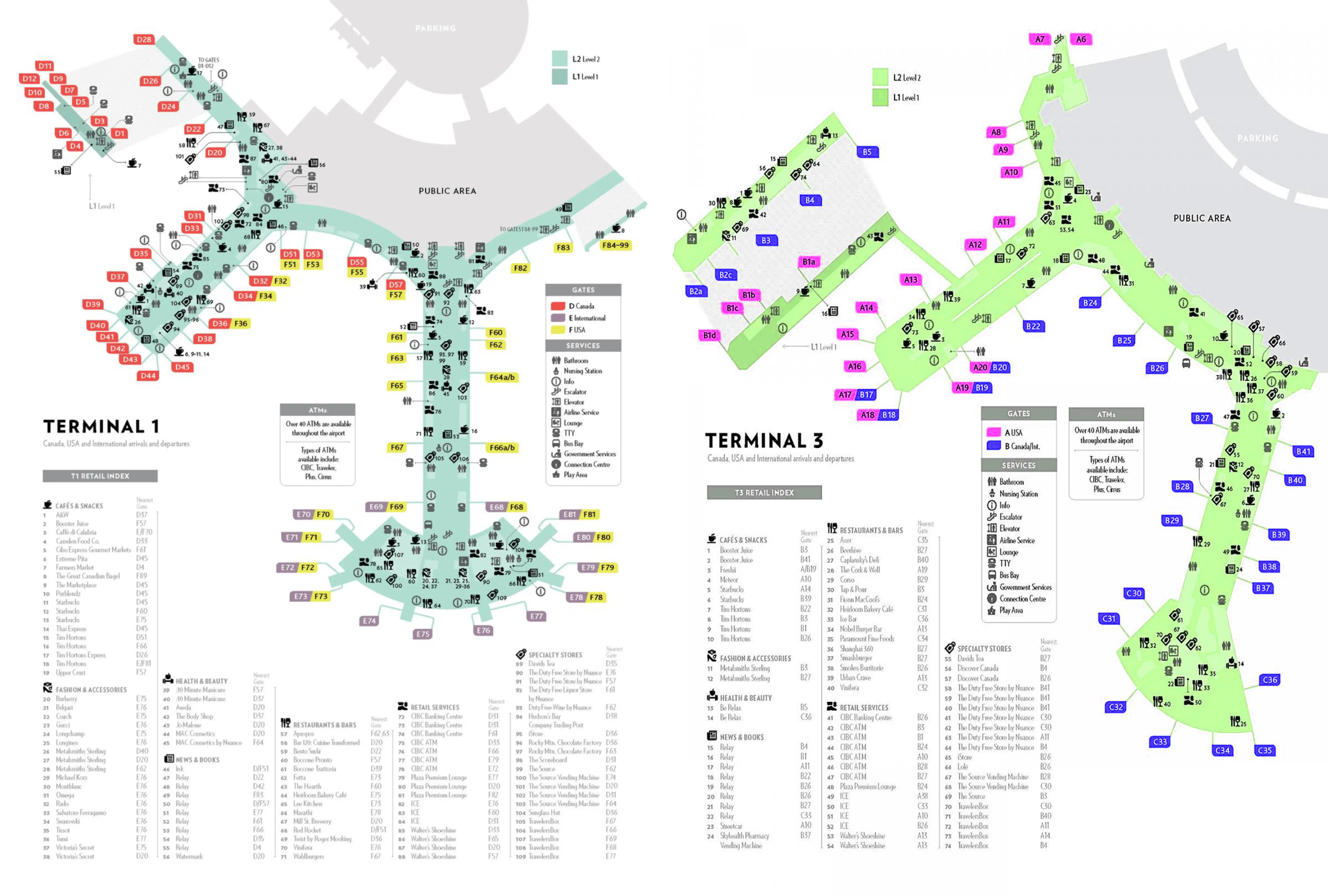
Pearson (YYZ) is a two-terminal, multi-level hub where the real navigation challenge is vertical: Arrivals and Departures sit on different road decks, while key connectors (Terminal Link + UP Express) live inside adjacent garage/hotel structures rather than the main halls. Terminal 1 runs as a centralized “processor” feeding long piers, and Terminal 3 follows a more linear flow. Use this map as your guide within Toronto’s main airport grounds to lock the correct level, bridge, and door before you walk.
Map Table
| Terminal | Key Airlines | Primary Function | Transfer Mode |
|---|---|---|---|
| Terminal 1 | Air Canada, Star Alliance | Central processor, piers D/E/F | Terminal Link via Parking Garage Level 5; UP Express adjacent |
| Terminal 3 | WestJet, SkyTeam, Oneworld mix | Linear hall, roadway-separated hotel/garage | Terminal Link via Sheraton bridge; access Level 3, platform Level 1 |
| Viscount Station | Value Park, remote access | Remote parking node | Terminal Link; Kiss & Ride below station level |
| Terminal Link | APM train | T1 ↔ T3 ↔ Viscount | 24/7 APM; Level 5 at T1, Level 1 platform at T3 |
Lester B. Pearson International Airport Map Strategy
- Treat every decision as a level check before a direction check: Terminal Link/UP Express at Level 5, main security at Departures Level 3, standard rideshare at Ground Level.
- For Terminal 1 security, aim for the central checkpoint zone aligned roughly with Aisles 8–10; the queue start is the barrier-maze area behind those aisles, not wherever the crowd looks thickest.
- For Terminal 1 ↔ Terminal 3, navigate to the bridge first (T1 Level 2 pedestrian bridge into the garage; T3 Level 3 Sheraton pedestrian bridge), then handle the final up/down move to the platform.
- For pickups, lock the door letter and curb logic before exiting customs: taxis/limos on Arrivals Level doors, standard Uber/Lyft down one level at Door Q/P (inner curb), premium app pickups at different doors/levels.
2026 Lester B. Pearson International Airport Map + Printable PDF
Pearson’s 2026 wayfinding still rewards “level-first” decisions: Terminal Link and UP Express are up at Level 5 by Terminal 1’s parking structure, while standard rideshare pickup is down at Ground Level (not the Arrivals curb). A printable PDF map is most useful when it highlights exact levels, bridge crossings, and door letters so you can commit to one correct route and avoid backtracking.
2026 Lester B. Pearson International Airport Map Guide
What is the exact Terminal 1 location (level + nearest landmark) of the Terminal Link boarding point to Terminal 3?
The Terminal Link boarding point at Terminal 1 is on Level 5 in the Terminal 1 Parking Garage rail hub, co-located with the UP Express station.
Reaching it requires leaving the main terminal hall and using the mezzanine bridge connection: go to Level 2 (Mezzanine), follow the pedestrian bridge west into the Terminal 1 parking structure, then take the garage elevator/escalator up to Level 5 for the shared UP Express/Terminal Link platform area. If you’re still inside the Departures or Arrivals hall, you’re one bridge away from the correct structure.
What is the exact Terminal 3 location (level + nearest landmark) where the Terminal Link arrives from Terminal 1?
The Terminal Link arrives at Terminal 3 on the Level 1 platform inside the Sheraton Gateway Hotel / parking garage complex.
Access is via the enclosed Sheraton pedestrian bridge: from Terminal 3 Arrivals (Level 1), go up to Level 3 to reach the bridge connection (elevator near Door D, escalator near Door F), cross toward the Sheraton Gateway Hotel, then go back down to Level 1 on the hotel/garage side to the Terminal Link platform. If you can’t see Sheraton bridge signage, you’re still on the terminal side and haven’t made the roadway crossing.
In Terminal 1 departures, where is the physical start of the main security queue (the first point a passenger can join) relative to the check-in aisles?
The physical start of Terminal 1’s main security queue is the barrier-tape “maze” area in the open atrium space directly behind the central check-in aisles, roughly aligned with Aisles 8–10 on the Departures Level (Level 3).
Security screening is centralized, so the join point is not at the far ends of the hall near the lowest or highest aisle numbers. The first place you can actually enter the line is where stanchions begin clustering behind the mid-hall counters near Aisles 8–10, at the back side of those aisles facing toward the security complex. If you’re walking along the curb-facing side of the counters, loop behind the counters toward the center atrium to find the real queue start.
What is the walking distance (meters) from the Terminal 1 check-in aisles commonly used by Air Canada to the primary security entry used during peak periods?
Walking is about 328 meters from Terminal 1’s Air Canada check-in area at Aisle 12 to the primary peak-period security entry at Security Checkpoint D.
That route is a long, straight hall traverse from the check-in counters toward the central security complex on Departures Level (Level 3). The distance is roughly a five-minute walk at a moderate pace with luggage, before any time spent finding the correct queue start or waiting in the stanchion maze. If you’re dropped at the wrong end of the departures frontage, this single segment can quietly consume most of a tight buffer.
At Terminal 1 arrivals, where is Door Q located on the curb loop (level + position along the terminal frontage) relative to the nearest escalators/elevators from baggage claim?
Door Q is on Terminal 1 Ground Level (Level 0), on the inner curb, positioned at the far end of the terminal frontage from the main Arrivals-level exits.
From the baggage claim/Arrivals Level (Level 1), the correct move is to take the nearest escalator/elevator bank down one floor following “Ground Transportation” or “Ride App Pickup” signage, then walk along the Ground Level curb loop to the Door Q segment. The key triangulation is that Door Q is not reachable by walking along the Arrivals Level doors—once you’re outside at Level 1, you’re on the wrong deck for Door Q.
What is the exact curbside segment (door/zone) designated for rideshare pickup at Terminal 1, and where is it positioned relative to the main arrivals hall exits?
Standard rideshare pickup at Terminal 1 is on Ground Level (Level 0) at the inner curb, primarily at Door Q (sometimes Door P).
From the main Arrivals hall exits (the doors you reach right after customs, typically around Doors D/E/F), do not step out to the Arrivals curb for UberX/Lyft. Stay inside, follow “Ride App Pickup/Ground Transportation,” go down one level by elevator/escalator, then walk along the Ground Level frontage to the inner-curb Door Q/P segment. Premium rides (Uber Black/Lux) use Arrivals Level at Door A, so matching your ride type to the correct level is the failure point that causes most cancellations.
From the Terminal 1 international arrival gates, what is the exact corridor route to primary passport control, including the first major choke point where queues spill into the hallway?
The first major choke point is the escalator/elevator descent into the CBSA Primary Inspection Line hall, where queues back up and spill into the sterile glass corridor.
From the international E-gates area (E67–E79), follow the one-way sterile elevated glass walkways toward the central terminal block without exiting into the public concourse. Stay in the “Arrivals/Customs” flow until you reach the central processing area where purple “Connections” signage and Customs “B” checkpoint directions appear along the walkway. Continue past the connection-split zone if you are terminating in Toronto, then funnel into the escalator/elevator lobby that drops into primary passport control; this is where the line most often spills back into the corridor and blocks through-walkers.
In Terminal 1 arrivals, where is the first baggage belt/carousel cluster located relative to the customs exit path (the first decision point where passengers choose a direction)?
The first baggage carousel cluster is immediately outside the CBSA exit doors, directly off the customs exit path at the point where you step into the open baggage reclaim hall.
After primary inspection, you pass through the controlled exit into baggage reclaim on Arrivals Level (Level 1). The first “decision point” is the moment you clear the glass doors and can turn along the linear rows of carousels; the nearest cluster is right there—there isn’t a long hallway walk before baggage reclaim begins. Domestic flow typically feeds the lower-numbered carousels (often 1–9), while international flow tends to feed higher-numbered carousels (often 10+), with the initial cluster positioned closest to your specific exit stream.
From Terminal 1 baggage claim, what is the shortest mapped route to the arrivals pickup curb exits (identify the exact door set nearest the carousels)?
The shortest route is straight out of the customs exit into the public Arrivals Hall, then out the nearest lettered doors on the Arrivals Level curb.
| Arrival stream | Nearest door set from customs exit | What’s on that curb outside |
|---|---|---|
| Domestic baggage claim | Doors B/C/D | Limo at Door C; taxi at Door D |
| International baggage claim | Doors D/E/F | Taxi at Door D; fastest general curb access via D/E/F doors |
Door D is the most reliable “default” exit because it anchors the main taxi stand and sits on the central Arrivals frontage. For standard Uber/Lyft, don’t exit to this Arrivals curb—go down one level inside to Ground Level pickup instead.
What is the exact indoor route from the UP Express platform area in Terminal 1 to the Terminal Link connection point (turn-by-turn via named connectors/levels)?
The Terminal Link connection from the UP Express in Terminal 1 is on the same Level 5 rail hub, a short walk (under 50 meters) with no level change.
| Step | Route segment | Level | Anchor point |
|---|---|---|---|
| 1 | Exit the UP Express train onto the platform | Level 5 | UP Express platform edge |
| 2 | Walk toward the station concourse/exit gates | Level 5 | Fare gates / station concourse |
| 3 | Follow “Terminal Link” signs beside the UP service/counter area | Level 5 | UP customer/service counters |
| 4 | Enter the adjacent Terminal Link platform area | Level 5 | Terminal Link platform boarding doors |
At Viscount Station, where is the Kiss & Ride located relative to the Terminal Link arrival point (distance + which exit)?
The Kiss & Ride is at ground level on the Viscount Road loop directly below the Terminal Link arrival at Viscount Station (which is on Level 4 of the Value Park Garage).
Arriving by Terminal Link, stay inside the station structure and take the main elevator/escalator bank down to Ground (surface) level following “Kiss & Ride” signage. The horizontal walk from the elevator lobby to the curb is short—under 50 meters—so the real distance is the vertical drop from Level 4 to Ground. Use the ground-level exit that opens onto the Viscount Road loop curb lane (the Kiss & Ride frontage immediately outside the garage).
What is the walking distance from a typical Terminal 1 international arrival gate area to the first immigration processing bank (kiosks/booths)?
Walking is typically 600–800 meters from the Terminal 1 international E-gates corridor to the first CBSA immigration processing banks.
The longest baseline is from the far end of the International Pier (around Gates E67–E79, especially near the tip) through the sterile glass walkway toward the central terminal block, then down the escalator/elevator into the Primary Inspection Line hall where the kiosks/booths begin. Gates closer to the central block shorten the walk, but the choke point at the customs-hall descent can add stop-and-go delays when queues spill back into the corridor.
In Terminal 1 departures, where is the NEXUS Enrollment Center positioned relative to Aisle 8 and the nearest major entrance doors/escalators?
The NEXUS Enrollment Center is on Terminal 1 Departures Level (Level 3), in the central public hall zone near Aisle 8, closest to the main Arrivals↔Departures connector escalators by the central atrium.
From the check-in hall, orient on Aisle 8 as your mid-hall reference, then look toward the back-wall/side-corridor area adjacent to the central escalator banks that link down toward Arrivals. It sits landside (pre-security), in the same high-traffic central block where administrative/service offices cluster, and it’s reached before you commit into the security queue maze.
Archive Lester B. Pearson International Airport Map
Below are all historical map versions for Lester B. Pearson International Airport. Each year includes the official map available for that period, presented as both WebP and PDF.
2022-2025 Lester B Pearson International Airport Terminal Map (Official 2022 Edition)


