Dublin Airport Ground Transportation Map (2025)
Use this Dublin Airport Ground Transportation Map to spot bus zones, taxi ranks, and walking routes between Terminals 1 and 2.
Dublin Airport (DUB) runs two main terminals linked by covered walkways, which makes connections between transport hubs straightforward even in bad weather. Follow the blue “Buses & Coaches” signs from Arrivals Level 0 or the green “Taxis” zone markings outside each terminal.
This map highlights key pick-up points, city coach stops, and cycling access routes so you can plan your transfer or onward journey in minutes.
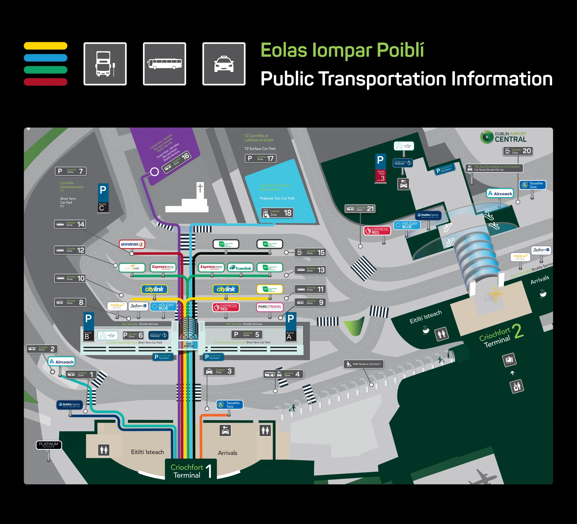
Dublin Airport T1 Bus Zones Map 2025
In 2025, bus activity at Dublin Airport Terminal 1 expanded with daily departures rising to 1,200, reflecting continued network growth following prior year increases.
On January 26, 2025, BusConnects Phase 6a introduced the new Route 19, operating between Dublin Airport, Dublin City University (DCU), and Merrion Square in the city centre, providing a high-frequency link integrated into the updated public transport network.
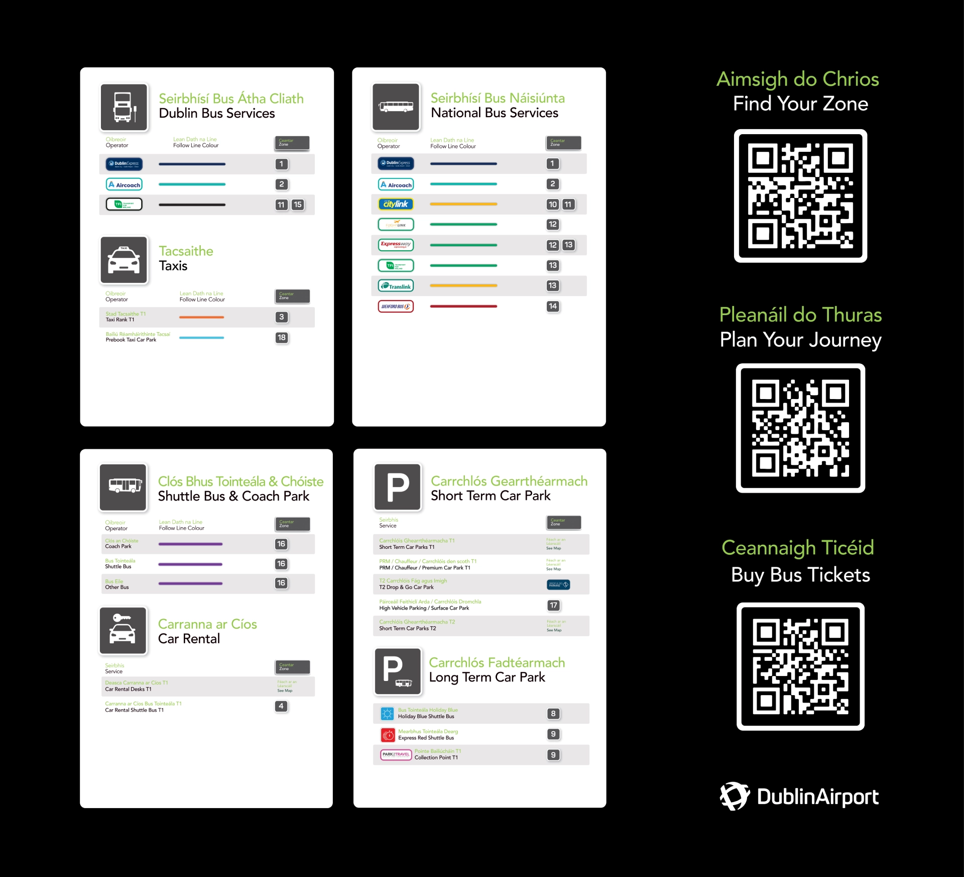
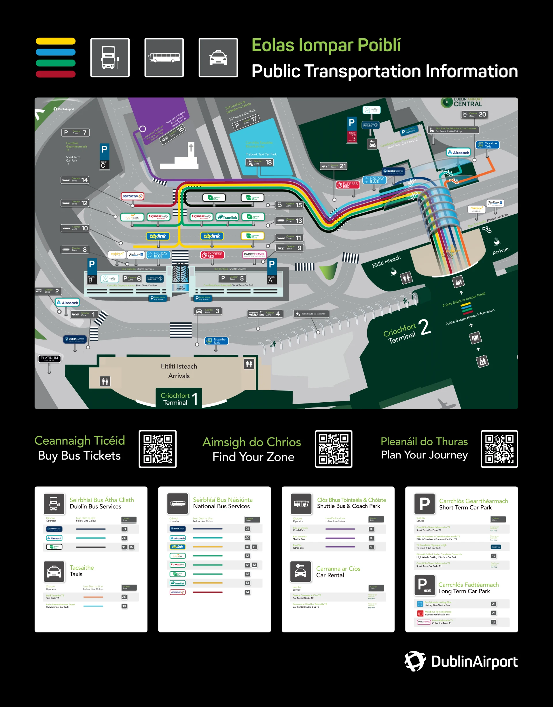
Dublin Airport T2 Bus Zones Map 2025
In 2025, Dublin Airport Terminal 2 bus operations expanded with daily departures across both terminals rising to 1,200.
A new tender ensured over 35 million annual bus seats and guaranteed seating availability for every passenger. Updated T2 Bus Zone maps and interactive guidance were introduced to improve passenger navigation.
Terminal 2 experienced a brief closure on September 20 due to a security alert, followed by operational delays caused by a Europe-wide cyberattack impacting check-in and boarding systems.
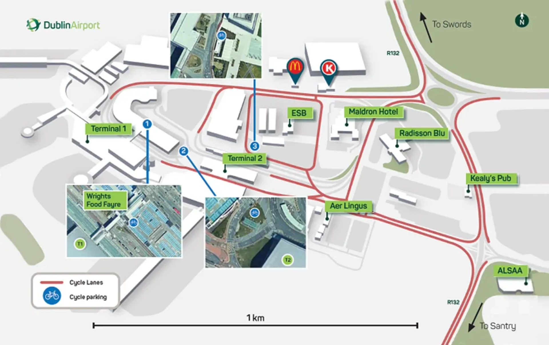
Dublin Airport Cycling Route Map 2025
In 2025, Dublin introduced an updated cycling infrastructure dataset mapping all routes within the metropolitan area, including new and upgraded connections serving Dublin Airport.
Approximately 50 kilometers of additional segregated cycle paths were added across the Greater Dublin Area network, expanding safe access for cyclists traveling to and from the airport and nearby transit corridors as part of the region’s comprehensive active travel improvements.
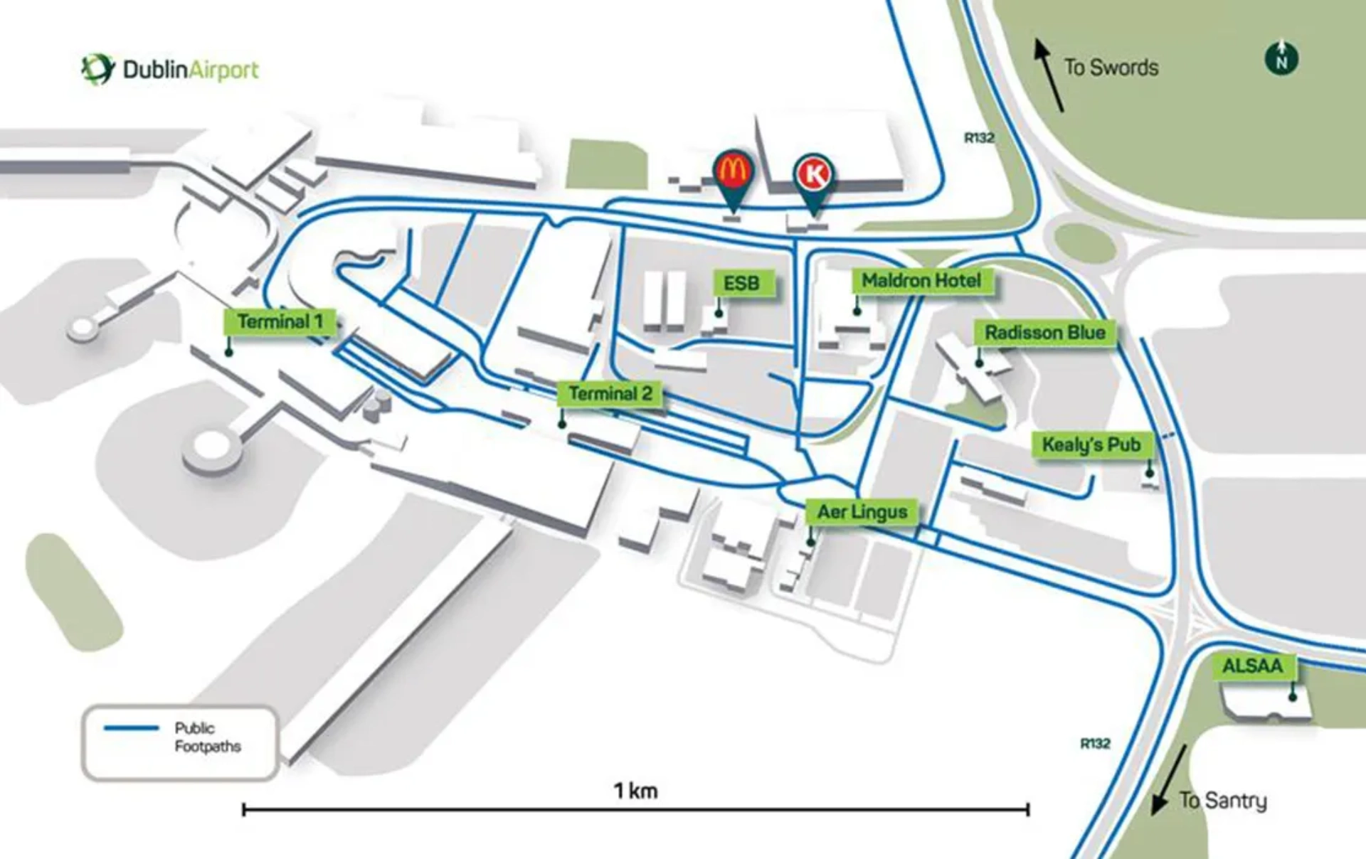
Dublin Airport Foothpaths and Walking Map 2025
In 2025, Dublin Airport upgraded pedestrian access along Old Airport Road with a new covered, fully lit viewing platform featuring improved footpaths, seating, and bike parking powered by on-site solar panels.
The existing viewing area and adjacent paths were temporarily closed on April 2 to support construction.
Covered walkways and signalised pedestrian crossings across the airport campus remained operational, maintaining established walking routes during and after the new facility’s development.
Printable Dublin Airport Ground Transportation Map PDF 2025
FAQ
What is the best way to get from Dublin Airport to city?
The best way to get from Dublin Airport to the city depends on budget and convenience. Dublin Express offers a quick, affordable transfer for €8–€10 per person, while taxis provide direct, flexible service for €25–€45. Journey times by both methods average 20 to 30 minutes.
How much is a taxi from Dublin Airport to city?
Taxi fares from Dublin Airport to the city center typically range from €25 to €45, depending on traffic, time of day, and exact destination. The average journey takes about 20 to 30 minutes under normal conditions.
Is the Dublin Express cheaper than a taxi?
The Dublin Express is generally cheaper than a taxi from Dublin Airport to the city. Dublin Express tickets cost around €8–€10 per person, while taxi fares typically range from €25–€35 for the same route.
How much is an Uber from Dublin Airport to the city?
An Uber from Dublin Airport to the city center typically costs between €25 and €35. Prices can vary depending on traffic, time of day, and demand. The ride usually takes 20 to 30 minutes.