Syracuse Hancock International Airport Map (Most Up-To-Date)
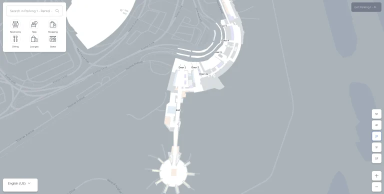
Syracuse Hancock International Airport runs as a compact, two-level terminal with a single central “Grand Hall” that feeds one TSA checkpoint upstairs and splits airside into two concourses (A south, B north). Landside flow concentrates at a few choke points—parking access, the central escalators, and the post-security left/right split—so small surges feel big. Use this Syracuse-area airport hub layout to plan decisive moves from curb, garage, or economy parking into the checkpoint.
Map Table
| Terminal | Key Airlines | Primary Function | Transfer Mode |
|---|---|---|---|
| Concourse A (South) | American, JetBlue, Allegiant, Breeze, Frontier, Sun Country | Gates 1–14 | Walk |
| Concourse B (North) | Delta, United | Gates 20–27 | Walk |
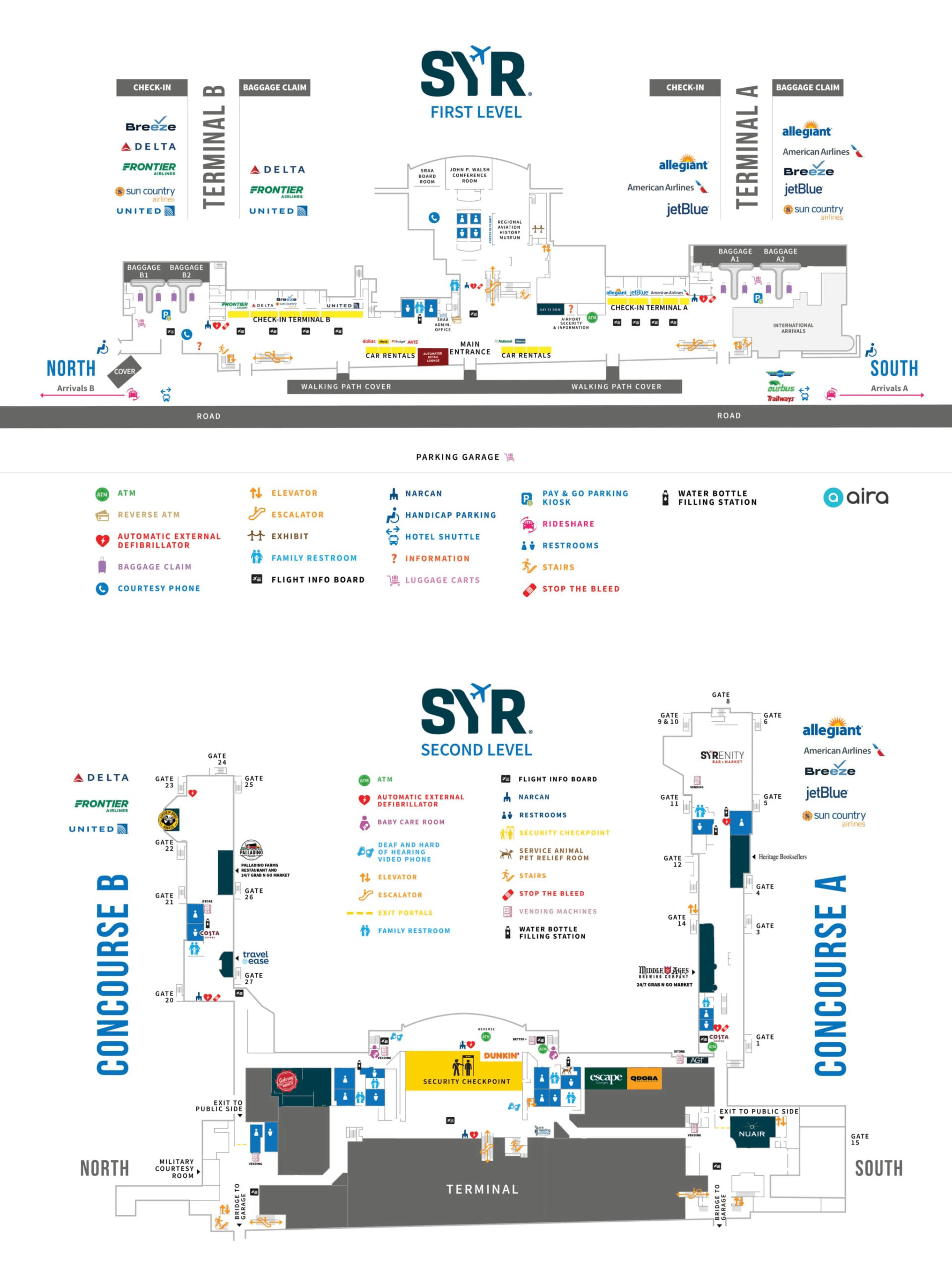
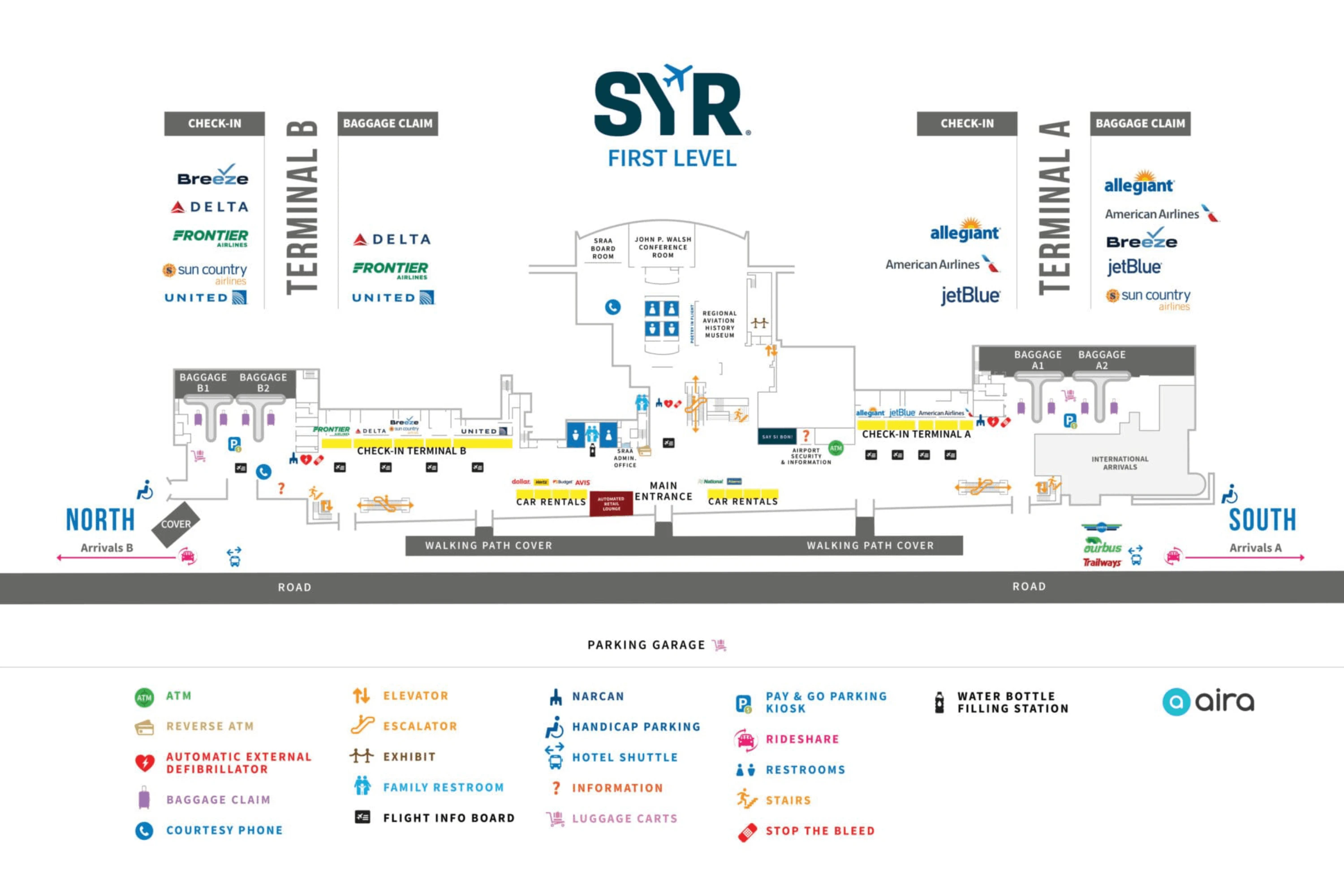
| Level 1 | All carriers | Ticketing, baggage claim, rental counters | Walk |
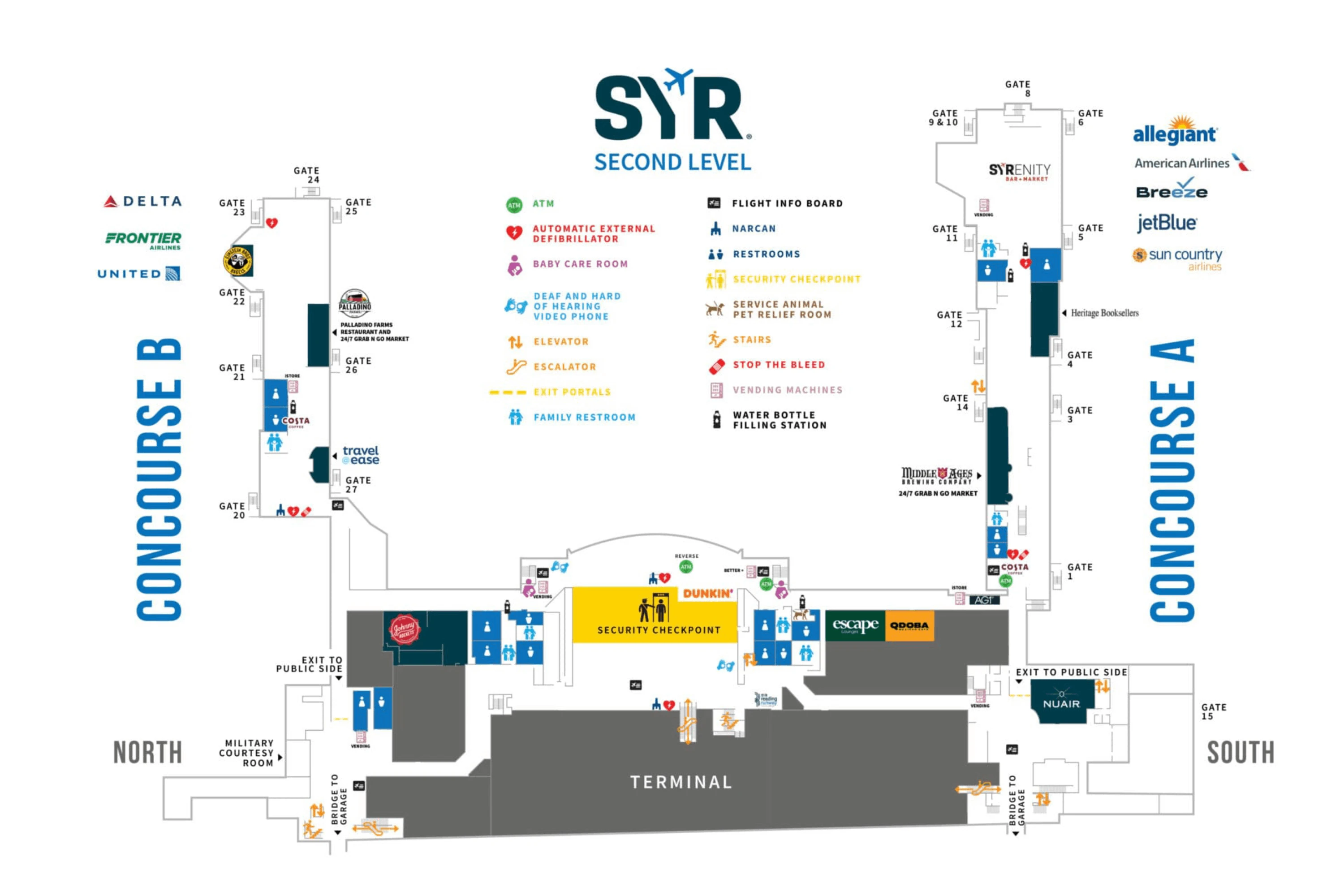
| Level 2 | All carriers | Single TSA checkpoint, gate access | Escalator, elevator |
Syracuse Hancock International Airport Map Strategy
- Treat Syracuse Hancock International Airport as a three-step funnel: parking choice → central escalators → one checkpoint → immediate left/right concourse decision; hesitation happens at those nodes, not at the gates.
- Build a “peak buffer” for the 4–6am TSA bank by arriving early enough to absorb a surprise queue at the escalator base and document-check podiums.
- Lock in your parking exit plan before you enter the building: economy users should commit to shuttle-vs-walk, and garage users should assume construction can force a level-change detour.
- Use end-bias rules to avoid wasted curb walking: the economy shuttle pickup is fixed to a specific arrivals-door zone, and rideshare pickup is biased toward the north end.
2026 Syracuse Hancock International Airport Map + Printable PDF
Active parking garage rehabilitation continues to reshape “car-to-checkpoint” timing at 2026, with bridge access and inventory shifting during phased work. The economy and overflow shuttle routing remains a key wayfinding detail, and the single checkpoint upstairs still drives the 4–6am stress spike when departures bank up. Expect the fastest trips when you commit early to the correct curb, door, and concourse split.
Syracuse Hancock International Airport Level 1 Map 2025-2026
Syracuse Hancock International Airport Level 2 Map 2025-2026
2026 Syracuse Hancock International Airport Map Guide
What is the exact walking route (step-by-step path) from the Economy Lot to the terminal entrance doors?
Walking takes about 8–10 minutes from the Economy Lot, and there is no enclosed or climate-controlled connector, so you’re fully exposed to weather and traffic noise the whole way.
Exit the Economy Lot on foot and orient toward the lot’s exit onto Constellation Road North. At the first key junction, turn onto Air Cargo Road in the direction of the terminal loop; missing this turn sends you away from the terminal-side complex. Stay on the Air Cargo Road shoulder/sidewalk corridor as it bends toward the main terminal area, then continue until you reach the terminal roadway and cross at the marked pedestrian crossing to the public entrance doors on Level 1. In winter, assume slick or uncleared segments on this stretch compared to the curbside area.
Where is the exact shuttle pickup point for Economy/Overflow parking (the specific curb/zone), relative to the main terminal doors?
The Economy and Overflow parking shuttle picks up at the Arrivals A Bus Lane by Door 1 on the south end of the arrivals curb.
From inside the terminal on Level 1, walk to the arrivals curbside and aim for Door 1 (the south arrivals doors). Outside those doors, look for the marked bus lane space used for the parking shuttle rather than the general passenger pickup line. If you exit at the north end (Terminal B side), you must walk the length of the curb south to Door 1 before waiting, because the shuttle stop is tethered to that Door 1 zone.
Where is the central TSA screening checkpoint entrance located on the departures level, and what is the shortest path to it from the parking garage bridge/entry?
The central TSA checkpoint entrance is on Level 2 directly ahead at the top of the central escalators from the Grand Hall, and the fastest reliable route from the garage during bridge construction is a Level 1 cross-and-ascend detour.
From the parking garage, use the elevator to go down to Level 1, then exit the garage and cross the roadway at the marked crosswalk into the terminal’s ground-level Grand Hall entrance area. Walk straight into the center of the Grand Hall and head to the central escalators (about 79 feet from the main center doors). Ride the escalators up to Level 2 and continue straight into the TSA queue entrance directly in front of you. If you try to use a closed bridge connection on the north side, you’ll waste time backtracking—commit to the Level 1 crosswalk route immediately.
Where is the TSA PreCheck lane physically positioned relative to the standard checkpoint at Syracuse Hancock International Airport (left/right/adjacent routing)?
The TSA PreCheck lane is positioned on the right side of the checkpoint setup when you approach the screening area head-on from the central escalators.
After you ride the central escalators up to Level 2, walk forward toward the document-check podiums and angle to the right-hand lanes closest to the Terminal A corridor side of the checkpoint. This is where the dedicated PreCheck routing is typically staged, adjacent to the standard lanes rather than in a separate checkpoint room. During lower-volume periods, Syracuse Hancock International Airport may run a blended configuration where the “PreCheck” lane light is off; in that case, stay to the right and follow blended-lane signs or staff direction while keeping PreCheck rules (shoes/laptops) as instructed.
From the checkpoint exit, what is the exact split point where passengers must choose between North Concourse B vs South Concourse A, and how is it signed?
The split happens immediately after the checkpoint recomposure area, where the airside corridor forks left for North Concourse B and right for South Concourse A.
After you clear screening and collect your items, walk forward into the center airside corridor and look up for the first large overhead direction signs. The decision is signed primarily by concourse letter and gate ranges: Concourse A with Gates 1–14 and Concourse B with Gates 20–27, with airline logos secondary. Turn right to enter the long hall toward Concourse A, or turn left to enter the hall toward Concourse B; there isn’t a separate central seating hall to “wait and decide,” so check your concourse or gate number before you reach this fork.
Where is the baggage claim office / help desk located relative to the carousels, and what is the fastest walking path from the last carousel to that desk?
The baggage claim office is on Level 1 near Carousel B at the south end of the baggage claim hall, close to the airline ticket counter side.
From Carousel B, face toward the open terminal hall (the ticketing/check-in direction) and walk only a short distance along the south end wall where the office cluster sits near the counters. If you’re coming from the north end (Carousels C or D), walk south down the long baggage claim hall past Carousels A and B until you reach the Carousel B end; the help desk is in that immediate south-end area rather than centered between the zones.
Which baggage carousel zone(s) serve the main carriers, and how are the carousels numbered/labeled from the arrivals exit?
The baggage claim carousels are labeled A, B, C, and D, and they run in an unexpected physical order from north to south: C → D → A → B.
| Carousel zone | Carousels | Main carriers |
|---|---|---|
| North end (Terminal B side) | C, D | Delta, United, Frontier |
| South end (Terminal A side) | A, B | American, JetBlue, Allegiant, Breeze, Sun Country |
From the arrivals exit portals and down to Level 1, the north end of the hall places you closest to Carousels C and D, while the south end puts you closest to A and B. The key trap is assuming “A starts first”; at Syracuse Hancock International Airport, C and D are the north-side pair and A and B sit farther south.
What is the exact indoor route from baggage claim to the rental car counters (first-level “center terminal” area), including which doors/corridor you take?
The rental car counters are inside the terminal on Level 1 in the center of the Grand Hall, so you can reach them without going outside.
From baggage claim, turn away from the carousels and walk toward the open central hall that connects both baggage zones. Stay inside and follow the “Rental Cars” overhead signs toward the middle of the building, heading in the direction of the central escalators. As you reach the center-terminal area between the north (C/D) and south (A/B) carousel zones, look along the back wall of the Grand Hall where the rental counters are grouped together pre-security. If you find yourself at an exterior door, you’ve gone too far—double back into the central hall instead of exiting curbside.
Where is the rental car return entrance relative to the terminal loop, and what is the last decision point (fork/turn) drivers commonly miss?
The rental car return entrance is inside the parking garage complex on the ground level, and the most-missed decision is the approach fork where drivers must stay left for the garage and rental return instead of drifting right into the arrivals/departures curb loop.
As you approach the terminal on Col. Eileen Collins Boulevard, watch for the roadway split just before the terminal frontage. Keep to the left lanes signed for Parking Garage and Rental Car Return (overhead green “Rental Car Return” guidance) so you’re routed into the garage structure rather than the curbside drop-off lanes. If you accidentally take the right lanes into the terminal loop, there’s no quick cut-through to the return entrance; you’ll be forced to complete the loop and recirculate around the airport road system to try again.
Where is the rideshare (Uber/Lyft) pickup zone located curbside, and what is the shortest walking path from baggage claim doors to that zone?
The rideshare pickup zone is at the north end of the curbside near the Terminal B side, and the shortest walk from Terminal A baggage claim is an indoor northbound walk first, not a long outdoor curb walk.
From baggage claim, stay inside on Level 1 and walk north through the Grand Hall toward the Terminal B end of the building. Exit at the north-side doors closest to the Terminal B curb, then follow the curbside signs for “App-Based Rideshare” or “TNC” to the designated pickup area. If you exit immediately at the south end (Terminal A doors), you can end up with an outdoor walk of roughly 1,100 feet; the indoor traverse to the north exit keeps you sheltered for most of the distance and drops you closer to the geofenced pickup zone.
Archive Syracuse Hancock International Airport Map
Below are all historical map versions for Syracuse Hancock International Airport. Each year includes the official map available for that period, presented as both WebP and PDF.
2025-2026 Syracuse Hancock International Airport Map (Official 2025 Edition)